


Manila Bulletin
 Philippines
National
PAGASA monitors another tropical depression outside PAR as 'Mirasol' crosses Northern Luzon
Philippines
National
PAGASA monitors another tropical depression outside PAR as 'Mirasol' crosses Northern Luzon
Philippines
National
PAGASA monitors another tropical depression outside PAR as 'Mirasol' crosses Northern Luzon
PAGASA monitors another tropical depression outside PAR as 'Mirasol' crosses Northern Luzon
TD Mirasol continues to traverse Northern Luzon, now over Kalinga
Published Sep 17, 2025 04:52 pm


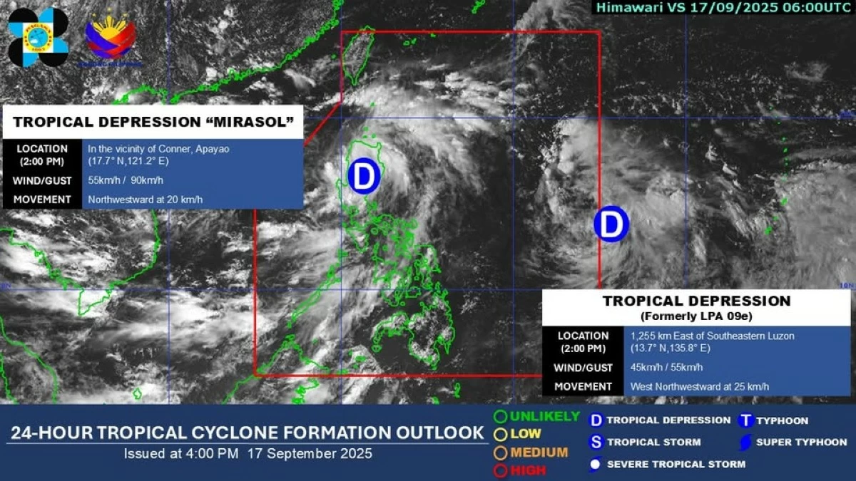
PAGASA tracks another tropical depression outside PAR as Tropical Depression Mirasol crosses Northern Luzon, bringing rains, winds, and sea travel risks. (PAGASA)
State weather bureau Philippine Atmospheric, Geophysical, and Astronomical Services Administration (PAGASA) said on Wednesday, September 17, that while Tropical Depression Mirasol continues to cross Northern Luzon, another tropical depression is also being monitored outside the Philippine Area of Responsibility (PAR).
As of 2 p.m., PAGASA said TD "Mirasol" is still being monitored within the Philippine Area of Responsibility (PAR). “Also, another Tropical Depression is being monitored outside PAR,” it added.
As of 1 p.m., “Mirasol” was located over Tanudan, Kalinga, packing maximum sustained winds of 55 km/h near the center and gusts of up to 90 km/h. It is moving northwestward at 15 km/h.
PAGASA said the weather disturbance is expected to re-emerge over the Luzon Strait by evening and may intensify into a tropical storm within the next 24 hours.
Signal No. 1 up in several areas
PAGASA has hoisted Tropical Cyclone Wind Signal (TCWS) No. 1 in several areas including Batanes, Cagayan including Babuyan Islands, Isabela, Quirino, Nueva Vizcaya, the northern and central portions of Aurora (Dilasag, Casiguran, Dinalungan, Dipaculao, Baler, Maria Aurora), Apayao, Abra, Kalinga, Mountain Province, Ifugao, Benguet, Ilocos Norte, Ilocos Sur, La Union, the northeastern portion of Pangasinan (San Nicolas, Natividad, San Manuel, Sison, San Quintin, Tayug), and the northern portion of Nueva Ecija (Carranglan, Pantabangan).
Meanwhile, PAGASA said the southwest monsoon (habagat), enhanced by “Mirasol,” is also bringing gusty conditions and rains over Southern Luzon, the Bicol Region, MIMAROPA, and Western Visayas.
PAGASA warned that Metro Manila and more areas in Luzon and Visayas may also experience rains and gusts by Thursday, September 18.
Another tropical depression is being monitored
PAGASA also confirmed that a separate tropical depression outside PAR is being closely monitored.
While it is still too far to directly affect the country, forecasters said they are tracking its potential path and development, as it may enhance rains or eventually enter the PAR in the coming days.
Sea travel risks
PAGASA warned of moderate to rough sea conditions in the seaboards of Cagayan, Isabela, Aurora, and Ilocos Region.
Small vessels and fishermen are advised to avoid venturing into the seas due to risky wave conditions reaching up to 3 meters, PAGASA added.
Forecast track
PAGASA said “Mirasol” is expected to exit PAR by Thursday, September 18, but it could strengthen into a tropical storm or even a severe tropical storm while over the Luzon Strait.
The additional tropical depression outside PAR remains under observation for possible effects on the country’s weather.
PAGASA advised the public and local disaster risk reduction offices to remain vigilant and continue monitoring official bulletins.
RELATED STORY: