ADVERTISEMENT

'Mirasol' makes landfall in Casiguran, Aurora — PAGASA

Heavy rains and strong winds are expected across Northern Luzon

Published Sep 17, 2025 04:52 am
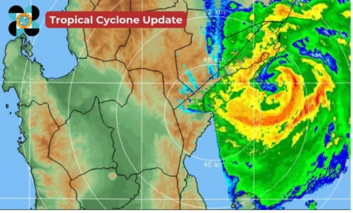
PAGASA warns of possible heavy rains, strong winds, flash floods, and landslides across Northern Luzon as Tropical Depression Mirasol makes landfall in Casiguran, Aurora, early on the morning of September 17, 2025. (PAGASA)
Tropical Depression Mirasol made landfall over Casiguran, Aurora, early Wednesday morning, September 17, according to the Philippine Atmospheric, Geophysical, and Astronomical Services Administration (PAGASA).
“At 3:20 a.m. today, the center of Tropical Depression MIRASOL made landfall over Casiguran, Aurora,” PAGASA said in its tropical cyclone update.
In its 24-hour public weather forecast issued at 4:00 a.m., PAGASA said “Mirasol” was estimated, based on all available data, to be over the coastal waters of Casiguran, Aurora, with maximum sustained winds of 55 km/h near the center and gusts of up to 90 km/h. It is moving northwestward at 10 km/h.
PAGASA said strong winds extend up to 200 km from the center, prompting Tropical Cyclone Wind Signal (TCWS) No. 1 across multiple areas in Luzon, including Batanes, Cagayan including Babuyan Islands, Isabela, Quirino, the northern and eastern portions of Nueva Vizcaya (Diadi, Quezon, Kasibu, Dupax del Norte, Bambang, Ambaguio, Bayombong, Solano, Villaverde, Bagabag, Alfonso Castañeda, Dupax del Sur), the northern and central portions of Aurora (Dilasag, Casiguran, Dinalungan, Dipaculao, Baler, Maria Aurora, San Luis), Apayao, Abra, Kalinga, Mountain Province, Ifugao, Ilocos Norte, the northern portion of Ilocos Sur (Sinait, Cabugao, San Juan, Magsingal, Santo Domingo, Bantay, San Vicente, San Ildefonso, Santa Catalina, City of Vigan, Caoayan, Santa), Polillo Islands, and the northern portion of Camarines Norte (Capalonga, Jose Panganiban, Paracale, Vinzons).
PAGASA noted that minimal to minor damage to life and property is expected due to these winds, though localized areas may experience stronger gusts.
Weather and rainfall outlook
In its latest public weather forecast, PAGASA said the southwest monsoon (habagat) is also affecting Southern Luzon and the western sections of Visayas and Mindanao.
In Cagayan Valley, the Cordillera Administrative Region, Aurora, Ilocos Norte, Ilocos Sur, and Polillo Islands, rains with gusty winds are expected due to TD Mirasol. PAGASA warned of possible floods or landslides from moderate to heavy rains, as well as a minimal to minor threat to life and property from strong winds.
In Metro Manila, the rest of the Ilocos Region, the rest of Central Luzon, and the rest of Calabarzon, PAGASA said cloudy skies with scattered rains and thunderstorms caused by “Mirasol” are also expected, along with possible flash floods or landslides from moderate to occasionally heavy rains.
PAGASA said cloudy skies with scattered rains and thunderstorms are expected in the Bicol Region, MIMAROPA, Western Visayas, Negros Island Region, Central Visayas, and Zamboanga Peninsula due to the “habagat.” Flash floods or landslides from moderate to occasionally heavy rains are possible, the weather bureau warned.
Meanwhile, partly cloudy to cloudy skies with isolated rain showers or thunderstorms caused by localized thunderstorms are expected in the rest of the country. PAGASA said flash floods or landslides during severe thunderstorms are also possible.
PAGASA also noted that moderate to strong winds and rough seas (1.5–3.2 meters) are expected in northern and eastern Luzon and parts of Visayas.
Mariners, especially operators of motorbancas, are advised to exercise caution or avoid venturing out to sea, PAGASA said.
TD Mirasol forecast and track
PAGASA said “Mirasol” is forecast to traverse Northern Luzon, re-emerging over the Luzon Strait by evening, where it is expected to intensify into a tropical storm, with a possibility of reaching severe tropical storm status.
PAGASA has also warned of a potential Tropical Cyclone Wind Signal No. 2 in some areas of Northern Luzon if intensification occurs.
Meanwhile, PAGASA said another Low Pressure Area (LPA) outside the Philippine Area of Responsibility (PAR) has a “medium” chance of developing into a tropical depression within 24 hours.
PAGASA advised authorities and residents in high-risk areas to follow local disaster preparedness measures, evacuate if necessary, and monitor official advisories.
RELATED STORY: 
https://mb.com.ph/2025/09/16/tropical-cyclone-mirasol-tracker


Related Tags

MirasolPH Tropical Depression Mirasol PAGASA weather update weather Philippines Flood and landslide alerts TD Mirasol MirasolPH track and forecast
ADVERTISEMENT
.most-popular .layout-ratio{ padding-bottom: 79.13%; } @media (min-width: 768px) and (max-width: 1024px) { .widget-title { font-size: 15px !important; } }

{{ articles_filter_1561_widget.title }}

.most-popular .layout-ratio{ padding-bottom: 79.13%; } @media (min-width: 768px) and (max-width: 1024px) { .widget-title { font-size: 15px !important; } }

{{ articles_filter_1562_widget.title }}

.most-popular .layout-ratio{ padding-bottom: 79.13%; } @media (min-width: 768px) and (max-width: 1024px) { .widget-title { font-size: 15px !important; } }

{{ articles_filter_1563_widget.title }}

{{ articles_filter_1564_widget.title }}

.mb-article-details { position: relative; } .mb-article-details .article-body-preview, .mb-article-details .article-body-summary{ font-size: 17px; line-height: 30px; font-family: "Libre Caslon Text", serif; color: #000; } .mb-article-details .article-body-preview iframe , .mb-article-details .article-body-summary iframe{ width: 100%; margin: auto; } .read-more-background { background: linear-gradient(180deg, color(display-p3 1.000 1.000 1.000 / 0) 13.75%, color(display-p3 1.000 1.000 1.000 / 0.8) 30.79%, color(display-p3 1.000 1.000 1.000) 72.5%); position: absolute; height: 200px; width: 100%; bottom: 0; display: flex; justify-content: center; align-items: center; padding: 0; } .read-more-background a{ color: #000; } .read-more-btn { padding: 17px 45px; font-family: Inter; font-weight: 700; font-size: 18px; line-height: 16px; text-align: center; vertical-align: middle; border: 1px solid black; background-color: white; } .hidden { display: none; }
function initializeAllSwipers() { // Get all hidden inputs with cms_article_id document.querySelectorAll('[id^="cms_article_id_"]').forEach(function (input) { const cmsArticleId = input.value; const articleSelector = '#article-' + cmsArticleId + ' .body_images'; const swiperElement = document.querySelector(articleSelector); if (swiperElement && !swiperElement.classList.contains('swiper-initialized')) { new Swiper(articleSelector, { loop: true, pagination: false, navigation: { nextEl: '#article-' + cmsArticleId + ' .swiper-button-next', prevEl: '#article-' + cmsArticleId + ' .swiper-button-prev', }, }); } }); } setTimeout(initializeAllSwipers, 3000); const intersectionObserver = new IntersectionObserver( (entries) => { entries.forEach((entry) => { if (entry.isIntersecting) { const newUrl = entry.target.getAttribute("data-url"); if (newUrl) { history.pushState(null, null, newUrl); let article = entry.target; // Extract metadata const author = article.querySelector('.author-section').textContent.replace('By', '').trim(); const section = article.querySelector('.section-info ').textContent.replace(' ', ' '); const title = article.querySelector('.article-title h1').textContent; // Parse URL for Chartbeat path format const parsedUrl = new URL(newUrl, window.location.origin); const cleanUrl = parsedUrl.host + parsedUrl.pathname; // Update Chartbeat configuration if (typeof window._sf_async_config !== 'undefined') { window._sf_async_config.path = cleanUrl; window._sf_async_config.sections = section; window._sf_async_config.authors = author; } // Track virtual page view with Chartbeat if (typeof pSUPERFLY !== 'undefined' && typeof pSUPERFLY.virtualPage === 'function') { try { pSUPERFLY.virtualPage({ path: cleanUrl, title: title, sections: section, authors: author }); } catch (error) { console.error('ping error', error); } } // Optional: Update document title if (title && title !== document.title) { document.title = title; } } } }); }, { threshold: 0.1 } ); function showArticleBody(button) { const article = button.closest("article"); const summary = article.querySelector(".article-body-summary"); const body = article.querySelector(".article-body-preview"); const readMoreSection = article.querySelector(".read-more-background"); // Hide summary and read-more section summary.style.display = "none"; readMoreSection.style.display = "none"; // Show the full article body body.classList.remove("hidden"); } document.addEventListener("DOMContentLoaded", () => { let loadCount = 0; // Track how many times articles are loaded const offset = [1, 2, 3, 4, 5, 6, 7, 8, 9, 10]; // Offset values const currentUrl = window.location.pathname.substring(1); let isLoading = false; // Prevent multiple calls if (!currentUrl) { console.log("Current URL is invalid."); return; } const sentinel = document.getElementById("load-more-sentinel"); if (!sentinel) { console.log("Sentinel element not found."); return; } function isSentinelVisible() { const rect = sentinel.getBoundingClientRect(); return ( rect.top < window.innerHeight && rect.bottom >= 0 ); } function onScroll() { if (isLoading) return; if (isSentinelVisible()) { if (loadCount >= offset.length) { console.log("Maximum load attempts reached."); window.removeEventListener("scroll", onScroll); return; } isLoading = true; const currentOffset = offset[loadCount]; window.loadMoreItems().then(() => { let article = document.querySelector('#widget_1690 > div:nth-last-of-type(2) article'); intersectionObserver.observe(article) loadCount++; }).catch(error => { console.error("Error loading more items:", error); }).finally(() => { isLoading = false; }); } } window.addEventListener("scroll", onScroll); });

Sign up by email to receive news.