


Manila Bulletin
 Philippines
National
14 areas under Signal No. 1 as 'Mirasol' traverses Northern Luzon — PAGASA
Philippines
National
14 areas under Signal No. 1 as 'Mirasol' traverses Northern Luzon — PAGASA
Philippines
National
14 areas under Signal No. 1 as 'Mirasol' traverses Northern Luzon — PAGASA
14 areas under Signal No. 1 as 'Mirasol' traverses Northern Luzon — PAGASA
'Habagat' to bring gusty conditions to several areas
Published Sep 17, 2025 09:31 am


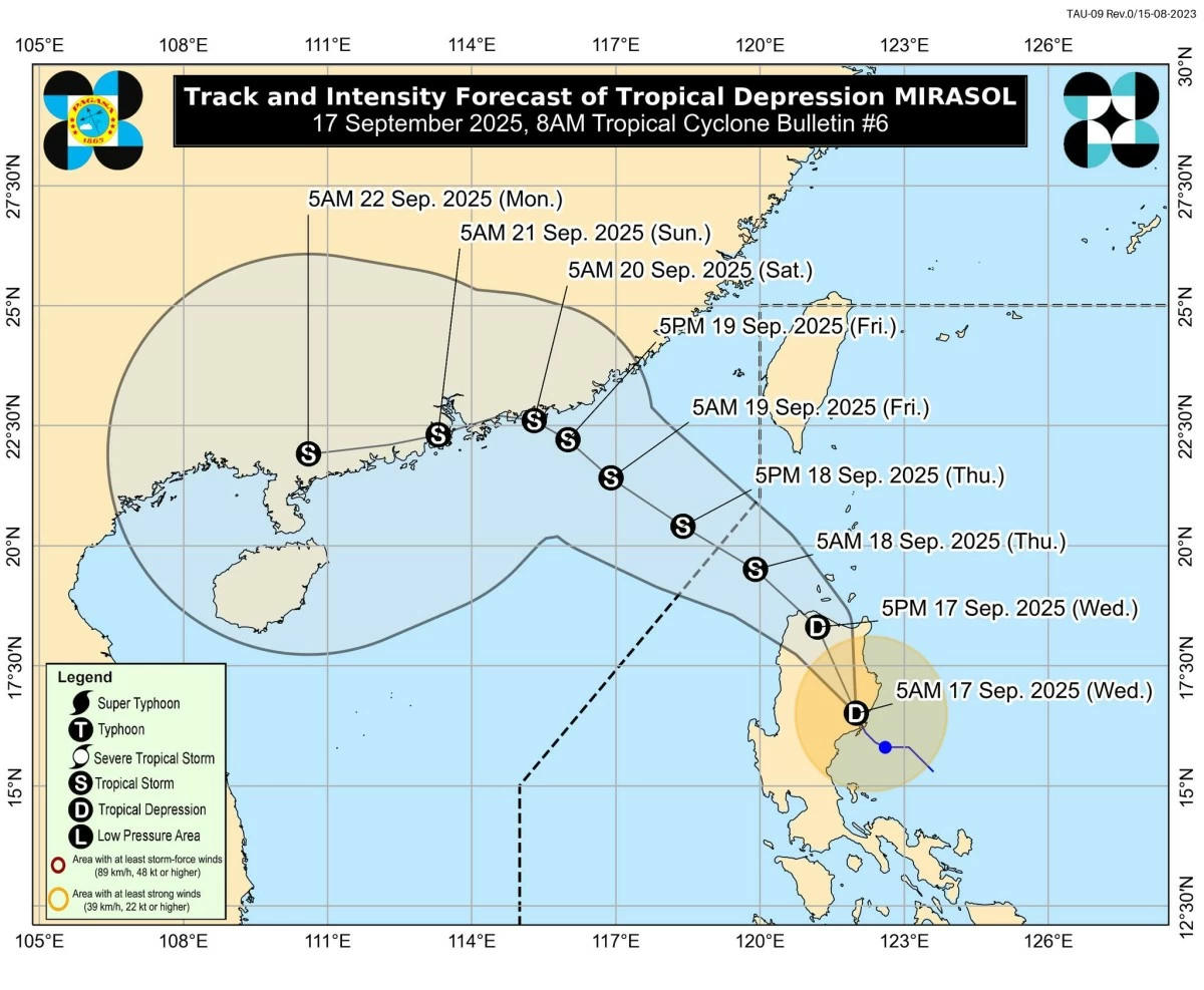
Tropical Depression Mirasol is crossing Northern Luzon with Signal No. 1 raised in 14 areas. (PAGASA)
Tropical Cyclone Wind Signal (TCWS) No. 1 remains in effect in 14 areas as Tropical Depression Mirasol moves across Northern Luzon on Wednesday, September 17.
In its latest bulletin, the Philippine Atmospheric, Geophysical and Astronomical Services Administration (PAGASA) said the center of Mirasol was located in the vicinity of San Agustin, Isabela, packing maximum sustained winds of 55 km/h, gusts of up to 90 km/h, and moving west-northwest at 25 km/h.
PAGASA said Mirasol is expected to re-emerge over the Luzon Strait later today, where it may strengthen into a tropical storm.
Meanwhile, TCWS No. 1 is raised over the following Luzon areas:
- Batanes
- Cagayan, including the Babuyan Islands
- Isabela
- Quirino
- Northern and central portions of Aurora (Dilasag, Casiguran, Dinalungan, Dipaculao, Baler, Maria Aurora, San Luis)
- Apayao
- Abra
- Kalinga
- Mountain Province
- Ifugao
- Northern and eastern portions of Benguet (Bakun, Mankayan, Kabayan, Buguias, Kibungan, Atok, Bokod)
- Nueva Vizcaya
- Ilocos Norte
- Ilocos Sur
PAGASA warned that minimal to minor threats to life and property are possible due to strong winds, especially in coastal and upland areas.
Signal No. 2 may be raised in parts of Northern Luzon if “Mirasol” intensifies, it added.
Heavy rains, strong winds, and coastal hazards
While “Mirasol” continues to cross Northern Luzon, PAGASA said the southwest monsoon (habagat) is also bringing gusty conditions to several areas: Southern Quezon, Bicol Region, Marinduque, Romblon, Mindoro provinces, Palawan, Panay Island, Guimaras, and Negros Occidental (September 17); Metro Manila, Northern Luzon provinces, Bataan, Cavite, Quezon, Bicol Region, Mindoro provinces, Palawan, Marinduque, Romblon, Panay, and Guimaras (September 18); and Ilocos Norte, Ilocos Sur, La Union, Pangasinan, Zambales, and Bataan (September 19).
Sea conditions remain moderate to rough along the eastern seaboards of Cagayan and Isabela (up to 3.0 meters), and along the coasts of Aurora, Babuyan Islands, Batanes, and Ilocos Norte (up to 2.5 meters).
PAGASA advised small boats and motorbancas to avoid sailing in these waters.
Track and forecast
PAGASA said “Mirasol” will likely re-emerge over the Luzon Strait by Wednesday afternoon or evening and may intensify into a tropical storm by Thursday morning, September 18.
The cyclone is forecast to exit the Philippine Area of Responsibility (PAR) between Thursday morning and afternoon.
A possible upgrade to severe tropical storm category is not ruled out, PAGASA added.
Given this outlook, residents in affected areas are urged to take precautionary measures against possible flash floods, landslides, and strong winds.
RELATED STORY: