ADVERTISEMENT

'Mirasol' maintains strength, approaches Isabela and Northern Aurora — PAGASA

Published Sep 16, 2025 08:36 pm
PAGASA warns of heavy rainfall, strong winds, and flooding risks as Tropical Depression Mirasol maintains its strength while approaching Isabela and Northern Aurora. (PAGASA)
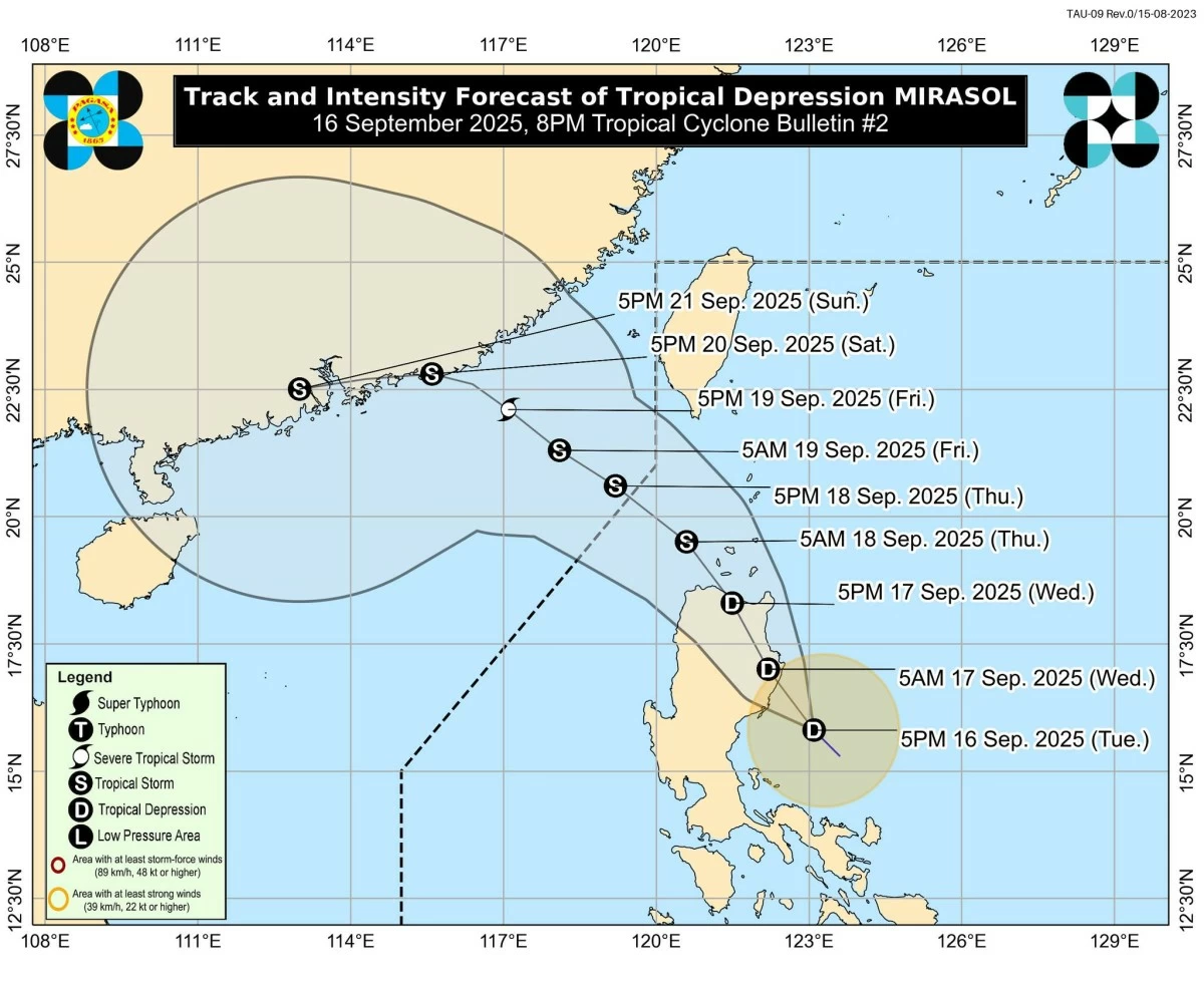
Tropical Depression Mirasol continues to maintain its strength as it moves northwestward, approaching Isabela and the northern portion of Aurora, the Philippine Atmospheric, Geophysical and Astronomical Services Administration (PAGASA) reported on Tuesday, September 16.
In its latest tropical cyclone bulletin, PAGASA said TD Mirasol poses threats of heavy rainfall, strong winds, and rough sea conditions over affected areas.
Tropical Depression Mirasol: Current status
As of 7 p.m., PAGASA reported that the center of “Mirasol” is located 170 km northeast of Infanta, Quezon, or 90 km southeast of Casiguran, Aurora.
TD Mirasol is moving northwestward at 25 km/h, with maximum sustained winds of 55 km/h and gusts reaching up to 70 km/h. The tropical cyclone produces strong winds extending up to 180 km from its center.
Wind signals and warnings
PAGASA has issued Tropical Cyclone Wind Signal (TCWS) No. 1 over areas in Luzon, including Batanes; Cagayan, including the Babuyan Islands; Isabela; Quirino; the northeastern portion of Nueva Vizcaya (Diadi, Quezon, Kasibu, Dupax del Norte, Bambang, Ambaguio, Bayombong, Solano, Villaverde, Bagabag); the northern and central portions of Aurora (Dilasag, Casiguran, Dinalungan, Dipaculao, Baler); Apayao; Kalinga; Abra; Mountain Province; Ifugao; Ilocos Norte; the northern portion of Ilocos Sur (Sinait, Cabugao, San Juan, Magsingal, Santo Domingo, Bantay, San Vicente, San Ildefonso, Santa Catalina, City of Vigan, Caoayan, Santa); Polillo Islands; the northern portion of Camarines Norte (Vinzons, Capalonga, Jose Panganiban, Paracale, Talisay, Daet, Mercedes); the northeastern portion of Camarines Sur (Caramoan, Garchitorena, Presentacion, Lagonoy, Siruma, Tinambac, Goa, San Jose); and Catanduanes.
Residents in these areas may experience minimal to minor impacts from strong winds, while coastal and mountainous regions could feel slightly stronger gusts.
PAGASA also warned that “Mirasol” is likely to intensify into a tropical storm once it moves over the Luzon Strait, potentially triggering TCWS No. 2 in some parts of Northern Luzon.
Heavy rainfall and flood risk
Referencing Weather Advisory No. 2 issued earlier, PAGASA said heavy rainfall is expected across Luzon, increasing the risk of flooding and landslides in low-lying and mountainous areas.
Local officials and residents were urged to monitor updates and take necessary precautions.
Sea conditions and marine advisory
Coastal waters in the northern seaboards of Cagayan, the Babuyan Islands, Batanes, Isabela, Aurora, and northern Ilocos Norte may experience moderate seas up to 2.5 meters.
Mariners, especially operators of small vessels, are advised to exercise extreme caution or avoid venturing out to sea.
TD Mirasol: Forecast track and intensity outlook
PAGASA said “Mirasol” continues to maintain its strength as it approaches the northern portion of Aurora and Isabela.
“On the forecast track, the center of Mirasol may make landfall in Isabela or the northern portion of Aurora by tomorrow morning,” PAGASA said.
“However, a more north-northwestward or northward movement may result in no landfall and the system will move over the coastal waters of Northern and Central Luzon,” the weather bureau added.
By Thursday morning, September 18, PAGASA said “Mirasol” is expected to re-emerge over the Luzon Strait and continue moving generally northwestward until it exits the Philippine Area of Responsibility between the afternoon and evening.
PAGASA added that “Mirasol” will maintain its strength or slightly weaken as it crosses Northern Luzon.
“Once it is over the West Philippine Sea, it is forecast to intensify and reach tropical storm category by Thursday morning,” PAGASA said.
The public and local disaster management offices were urged to take necessary measures to protect life and property, especially in areas highly susceptible to flooding, landslides, and strong winds.
Residents were also advised to follow evacuation orders and updates from local authorities, PAGASA added.

Related Tags

Mirasol PH Tropical Depression Mirasol PAGASA weather update heavy rainfall Philippines Isabela Aurora storm Philippines tropical storm Mirasol forecast track flooding
ADVERTISEMENT
.most-popular .layout-ratio{ padding-bottom: 79.13%; } @media (min-width: 768px) and (max-width: 1024px) { .widget-title { font-size: 15px !important; } }

{{ articles_filter_1561_widget.title }}

.most-popular .layout-ratio{ padding-bottom: 79.13%; } @media (min-width: 768px) and (max-width: 1024px) { .widget-title { font-size: 15px !important; } }

{{ articles_filter_1562_widget.title }}

.most-popular .layout-ratio{ padding-bottom: 79.13%; } @media (min-width: 768px) and (max-width: 1024px) { .widget-title { font-size: 15px !important; } }

{{ articles_filter_1563_widget.title }}

{{ articles_filter_1564_widget.title }}

.mb-article-details { position: relative; } .mb-article-details .article-body-preview, .mb-article-details .article-body-summary{ font-size: 17px; line-height: 30px; font-family: "Libre Caslon Text", serif; color: #000; } .mb-article-details .article-body-preview iframe , .mb-article-details .article-body-summary iframe{ width: 100%; margin: auto; } .read-more-background { background: linear-gradient(180deg, color(display-p3 1.000 1.000 1.000 / 0) 13.75%, color(display-p3 1.000 1.000 1.000 / 0.8) 30.79%, color(display-p3 1.000 1.000 1.000) 72.5%); position: absolute; height: 200px; width: 100%; bottom: 0; display: flex; justify-content: center; align-items: center; padding: 0; } .read-more-background a{ color: #000; } .read-more-btn { padding: 17px 45px; font-family: Inter; font-weight: 700; font-size: 18px; line-height: 16px; text-align: center; vertical-align: middle; border: 1px solid black; background-color: white; } .hidden { display: none; }
function initializeAllSwipers() { // Get all hidden inputs with cms_article_id document.querySelectorAll('[id^="cms_article_id_"]').forEach(function (input) { const cmsArticleId = input.value; const articleSelector = '#article-' + cmsArticleId + ' .body_images'; const swiperElement = document.querySelector(articleSelector); if (swiperElement && !swiperElement.classList.contains('swiper-initialized')) { new Swiper(articleSelector, { loop: true, pagination: false, navigation: { nextEl: '#article-' + cmsArticleId + ' .swiper-button-next', prevEl: '#article-' + cmsArticleId + ' .swiper-button-prev', }, }); } }); } setTimeout(initializeAllSwipers, 3000); const intersectionObserver = new IntersectionObserver( (entries) => { entries.forEach((entry) => { if (entry.isIntersecting) { const newUrl = entry.target.getAttribute("data-url"); if (newUrl) { history.pushState(null, null, newUrl); let article = entry.target; // Extract metadata const author = article.querySelector('.author-section').textContent.replace('By', '').trim(); const section = article.querySelector('.section-info ').textContent.replace(' ', ' '); const title = article.querySelector('.article-title h1').textContent; // Parse URL for Chartbeat path format const parsedUrl = new URL(newUrl, window.location.origin); const cleanUrl = parsedUrl.host + parsedUrl.pathname; // Update Chartbeat configuration if (typeof window._sf_async_config !== 'undefined') { window._sf_async_config.path = cleanUrl; window._sf_async_config.sections = section; window._sf_async_config.authors = author; } // Track virtual page view with Chartbeat if (typeof pSUPERFLY !== 'undefined' && typeof pSUPERFLY.virtualPage === 'function') { try { pSUPERFLY.virtualPage({ path: cleanUrl, title: title, sections: section, authors: author }); } catch (error) { console.error('ping error', error); } } // Optional: Update document title if (title && title !== document.title) { document.title = title; } } } }); }, { threshold: 0.1 } ); function showArticleBody(button) { const article = button.closest("article"); const summary = article.querySelector(".article-body-summary"); const body = article.querySelector(".article-body-preview"); const readMoreSection = article.querySelector(".read-more-background"); // Hide summary and read-more section summary.style.display = "none"; readMoreSection.style.display = "none"; // Show the full article body body.classList.remove("hidden"); } document.addEventListener("DOMContentLoaded", () => { let loadCount = 0; // Track how many times articles are loaded const offset = [1, 2, 3, 4, 5, 6, 7, 8, 9, 10]; // Offset values const currentUrl = window.location.pathname.substring(1); let isLoading = false; // Prevent multiple calls if (!currentUrl) { console.log("Current URL is invalid."); return; } const sentinel = document.getElementById("load-more-sentinel"); if (!sentinel) { console.log("Sentinel element not found."); return; } function isSentinelVisible() { const rect = sentinel.getBoundingClientRect(); return ( rect.top < window.innerHeight && rect.bottom >= 0 ); } function onScroll() { if (isLoading) return; if (isSentinelVisible()) { if (loadCount >= offset.length) { console.log("Maximum load attempts reached."); window.removeEventListener("scroll", onScroll); return; } isLoading = true; const currentOffset = offset[loadCount]; window.loadMoreItems().then(() => { let article = document.querySelector('#widget_1690 > div:nth-last-of-type(2) article'); intersectionObserver.observe(article) loadCount++; }).catch(error => { console.error("Error loading more items:", error); }).finally(() => { isLoading = false; }); } } window.addEventListener("scroll", onScroll); });

Sign up by email to receive news.