ADVERTISEMENT

Tropical Depression Mirasol forms east of Quezon — PAGASA

Thunderstorm warnings up across Luzon, Metro Manila

Published Sep 16, 2025 02:59 pm
Tropical Depression Mirasol has formed east of Quezon, according to PAGASA. (PAGASA)
The Philippine Atmospheric, Geophysical and Astronomical Services Administration (PAGASA) on Tuesday, September 16, announced that the Low Pressure Area (LPA) east of Infanta, Quezon has intensified into Tropical Depression Mirasol.
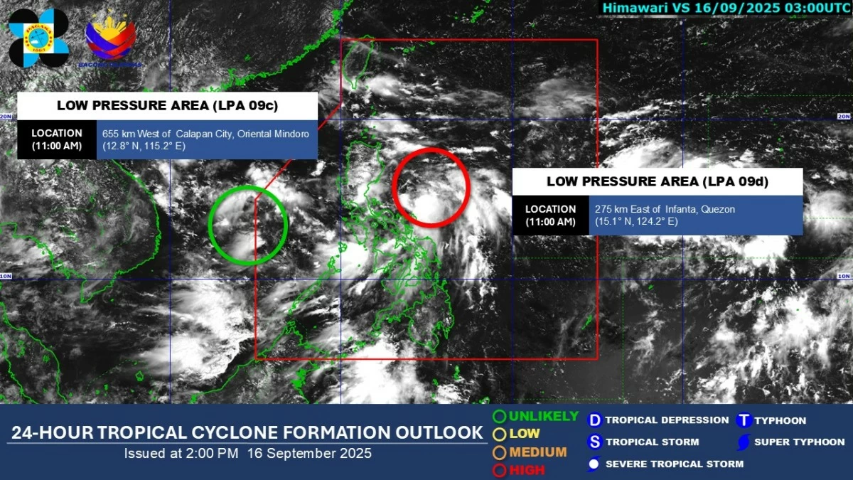
As of 2 p.m., PAGASA said one of the two LPAs being monitored inside the Philippine Area of Responsibility (PAR) had developed into a tropical depression, now called “Mirasol.”
Starting 5 p.m., PAGASA will begin issuing Tropical Cyclone Bulletins for TD Mirasol.
PAGASA earlier noted that the system near Infanta, Quezon had a “high” chance of developing into a tropical depression within 24 hours. With its formation, residents across Luzon are advised to brace for widespread rains and possible flooding.
Meanwhile, another LPA located west of Calapan City, Oriental Mindoro still has a “low” chance of intensifying into a tropical depression.
Thunderstorm warnings across Luzon, Metro Manila
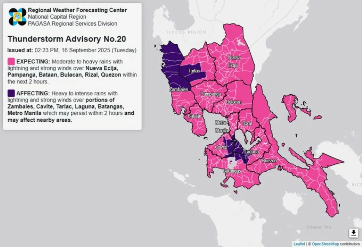
In its Thunderstorm Advisory No. 20, PAGASA warned of moderate to heavy rain showers with lightning and strong winds within two hours in Nueva Ecija, Pampanga, Bataan, Bulacan, Rizal, and Quezon.
Thunderstorm warnings are raised across Luzon and Metro Manila. (PAGASA)
The bureau also reported heavy to intense rainfall in parts of:
- Zambales (Cabangan, Botolan, Iba, Masinloc, Sta. Cruz, Candelaria, Palauig)
- Cavite (Silang, Dasmariñas, General Trias, Gen. Mariano Alvarez, Carmona, Tagaytay)
- Tarlac (Capas, San Jose)
- Laguna (San Pedro, Biñan, Sta. Rosa, Cabuyao, Los Baños, Calamba, Bay, Calauan, Alaminos)
- Batangas (Tanauan, Sto. Tomas, Talisay)
- Metro Manila (Muntinlupa)
PAGASA said these conditions may persist for the next two hours and could also affect nearby provinces.
The agency urged residents, especially those in low-lying and mountainous areas, to remain vigilant against flash floods and landslides.
PAGASA emphasized the importance of monitoring official updates on rainfall warnings, thunderstorm advisories, and tropical cyclone bulletins as TD Mirasol may continue to affect large parts of the country in the coming days.

Related Tags

MirasolPH TD Mirasol Philippines PAGASA weather update September 16 2025 tropical depression Philippines LPA PAR update PAGASA thunderstorm advisory Metro Manila weather
ADVERTISEMENT
.most-popular .layout-ratio{ padding-bottom: 79.13%; } @media (min-width: 768px) and (max-width: 1024px) { .widget-title { font-size: 15px !important; } }

{{ articles_filter_1561_widget.title }}

.most-popular .layout-ratio{ padding-bottom: 79.13%; } @media (min-width: 768px) and (max-width: 1024px) { .widget-title { font-size: 15px !important; } }

{{ articles_filter_1562_widget.title }}

.most-popular .layout-ratio{ padding-bottom: 79.13%; } @media (min-width: 768px) and (max-width: 1024px) { .widget-title { font-size: 15px !important; } }

{{ articles_filter_1563_widget.title }}

{{ articles_filter_1564_widget.title }}

.mb-article-details { position: relative; } .mb-article-details .article-body-preview, .mb-article-details .article-body-summary{ font-size: 17px; line-height: 30px; font-family: "Libre Caslon Text", serif; color: #000; } .mb-article-details .article-body-preview iframe , .mb-article-details .article-body-summary iframe{ width: 100%; margin: auto; } .read-more-background { background: linear-gradient(180deg, color(display-p3 1.000 1.000 1.000 / 0) 13.75%, color(display-p3 1.000 1.000 1.000 / 0.8) 30.79%, color(display-p3 1.000 1.000 1.000) 72.5%); position: absolute; height: 200px; width: 100%; bottom: 0; display: flex; justify-content: center; align-items: center; padding: 0; } .read-more-background a{ color: #000; } .read-more-btn { padding: 17px 45px; font-family: Inter; font-weight: 700; font-size: 18px; line-height: 16px; text-align: center; vertical-align: middle; border: 1px solid black; background-color: white; } .hidden { display: none; }
function initializeAllSwipers() { // Get all hidden inputs with cms_article_id document.querySelectorAll('[id^="cms_article_id_"]').forEach(function (input) { const cmsArticleId = input.value; const articleSelector = '#article-' + cmsArticleId + ' .body_images'; const swiperElement = document.querySelector(articleSelector); if (swiperElement && !swiperElement.classList.contains('swiper-initialized')) { new Swiper(articleSelector, { loop: true, pagination: false, navigation: { nextEl: '#article-' + cmsArticleId + ' .swiper-button-next', prevEl: '#article-' + cmsArticleId + ' .swiper-button-prev', }, }); } }); } setTimeout(initializeAllSwipers, 3000); const intersectionObserver = new IntersectionObserver( (entries) => { entries.forEach((entry) => { if (entry.isIntersecting) { const newUrl = entry.target.getAttribute("data-url"); if (newUrl) { history.pushState(null, null, newUrl); let article = entry.target; // Extract metadata const author = article.querySelector('.author-section').textContent.replace('By', '').trim(); const section = article.querySelector('.section-info ').textContent.replace(' ', ' '); const title = article.querySelector('.article-title h1').textContent; // Parse URL for Chartbeat path format const parsedUrl = new URL(newUrl, window.location.origin); const cleanUrl = parsedUrl.host + parsedUrl.pathname; // Update Chartbeat configuration if (typeof window._sf_async_config !== 'undefined') { window._sf_async_config.path = cleanUrl; window._sf_async_config.sections = section; window._sf_async_config.authors = author; } // Track virtual page view with Chartbeat if (typeof pSUPERFLY !== 'undefined' && typeof pSUPERFLY.virtualPage === 'function') { try { pSUPERFLY.virtualPage({ path: cleanUrl, title: title, sections: section, authors: author }); } catch (error) { console.error('ping error', error); } } // Optional: Update document title if (title && title !== document.title) { document.title = title; } } } }); }, { threshold: 0.1 } ); function showArticleBody(button) { const article = button.closest("article"); const summary = article.querySelector(".article-body-summary"); const body = article.querySelector(".article-body-preview"); const readMoreSection = article.querySelector(".read-more-background"); // Hide summary and read-more section summary.style.display = "none"; readMoreSection.style.display = "none"; // Show the full article body body.classList.remove("hidden"); } document.addEventListener("DOMContentLoaded", () => { let loadCount = 0; // Track how many times articles are loaded const offset = [1, 2, 3, 4, 5, 6, 7, 8, 9, 10]; // Offset values const currentUrl = window.location.pathname.substring(1); let isLoading = false; // Prevent multiple calls if (!currentUrl) { console.log("Current URL is invalid."); return; } const sentinel = document.getElementById("load-more-sentinel"); if (!sentinel) { console.log("Sentinel element not found."); return; } function isSentinelVisible() { const rect = sentinel.getBoundingClientRect(); return ( rect.top < window.innerHeight && rect.bottom >= 0 ); } function onScroll() { if (isLoading) return; if (isSentinelVisible()) { if (loadCount >= offset.length) { console.log("Maximum load attempts reached."); window.removeEventListener("scroll", onScroll); return; } isLoading = true; const currentOffset = offset[loadCount]; window.loadMoreItems().then(() => { let article = document.querySelector('#widget_1690 > div:nth-last-of-type(2) article'); intersectionObserver.observe(article) loadCount++; }).catch(error => { console.error("Error loading more items:", error); }).finally(() => { isLoading = false; }); } } window.addEventListener("scroll", onScroll); });

Sign up by email to receive news.