


TS Isang exits PAR; PAGASA lifts tropical cyclone wind signal
Enhanced 'habagat' to bring rains in several parts of the country
Published Aug 23, 2025 12:06 pm
|
Updated Aug 23, 2025 01:05 pm


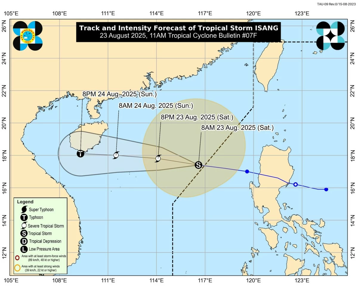
Tropical Storm Isang exits PAR but enhances the southwest monsoon, bringing strong winds, heavy rains, and rough seas. PAGASA lifts all wind signals. (PAGASA / Facebook)
Tropical Storm Isang (international name: Kajiki) has exited the Philippine Area of Responsibility (PAR) but will continue to enhance the southwest monsoon (habagat), which is expected to bring strong winds and rough sea conditions in several parts of the country, the Philippine Atmospheric, Geophysical and Astronomical Services Administration (PAGASA) announced on Saturday, August 23.
As of 11 a.m., PAGASA said the storm’s center was estimated at 440 kilometers west of Bacnotan, La Union (17.4 °N, 116.3 °E), moving westward at 30 kilometers per hour (kph). It was packing maximum sustained winds of 85 kph near the center and gusts of up to 105 kph.
Hazards affecting land areas, coastal waters
Although “Isang” is no longer inside PAR, it continues to slightly enhance the southwest monsoon, according to PAGASA.
The state weather bureau said this will bring strong to gale-force gusts over Batanes, Babuyan Islands, the Ilocos Region, Cordillera Administrative Region, Zambales, Bataan, Lubang Island, Romblon, and Kalayaan Islands today. From Sunday, August 24, until Monday, August 25, gusty winds will persist over the Kalayaan Islands.
PAGASA advised the public to remain alert for possible heavy rainfall brought by the enhanced monsoon, as detailed in its latest weather advisory.
Meanwhile, PAGASA said no gale warning has been raised, but sea travel remains risky in affected areas: rough seas (up to 3.5 meters) over the seaboards of the Ilocos Region, and moderate seas (up to 2.0 meters) over the seaboard of Cagayan Valley, Kalayaan Islands, western seaboards of Zambales, Bataan, Lubang Island, and the northwestern seaboard of Occidental Mindoro.
PAGASA cautioned operators of small vessels, especially motorbancas, to avoid venturing out to sea under these conditions.
Forecast and outlook; wind signals lifted
PAGASA said “Isang” is expected to continue its westward movement and may make landfall or pass close to Hainan, China, by Sunday afternoon or evening.
It is forecast to intensify further, reaching severe tropical storm category by Saturday night, August 23 and possibly strengthening into a typhoon by Sunday evening, August 24.
Despite its exit, PAGASA reminded the public and local government units to stay vigilant against monsoon rains and gusty conditions enhanced by the storm.
Currently, PAGASA said there are no tropical cyclone wind signals in effect over any part of the country.