ADVERTISEMENT

PAGASA: 'Isang' still inside PAR, being monitored

LPA inside the country's area of responsibility also being tracked

Published Aug 23, 2025 10:29 am
'Isang' strengthened into a tropical storm early August 23, and remains under close observation within the Philippine Area of Responsibility (PAR), according to the Philippine Atmospheric, Geophysical and Astronomical Services Administration (PAGASA). (PAGASA / Facebook)
Tropical Depression Isang, which intensified into a tropical storm early Saturday, August 23, is still being monitored inside the Philippine Area of Responsibility (PAR), according to the Philippine Atmospheric, Geophysical and Astronomical Services Administration (PAGASA).
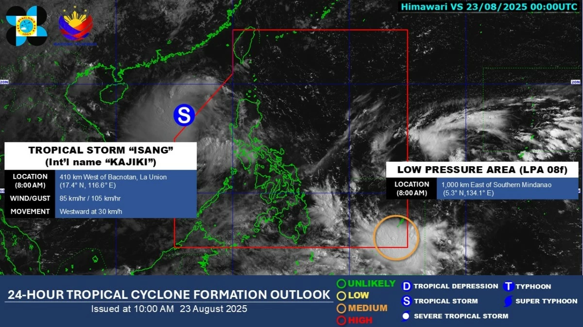
As of 8 a.m., PAGASA said Tropical Storm Isang remained inside the PAR.
TS Isang's center exits PAR
At 6:30 a.m., however, PAGASA announced that the center of "Isang" had already exited the PAR.
At 6:30 a.m., however, PAGASA announced that the center of
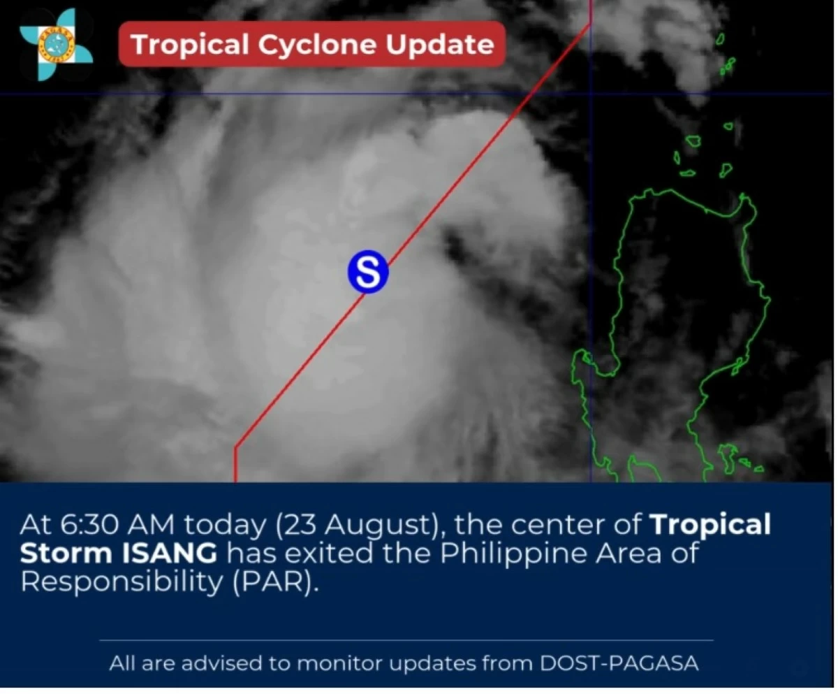
At 6:30 a.m., however, PAGASA announced that the center of "Isang" had already exited the PAR.(PAGASA / Facebook)

In its 5 a.m. bulletin, PAGASA reported that Isang was moving westward while enhancing the southwest monsoon or “habagat.” The storm was located 290 kilometers west of Bacnotan, La Union, with maximum sustained winds of 65 km/h near the center and gusts of up to 80 km/h. It was moving westward at 25 km/h and was expected to exit the PAR by morning.
LPA being monitored
Alongside Isang, PAGASA said it is also monitoring a Low Pressure Area (LPA) within the PAR.
The LPA has a medium chance of developing into a tropical depression within the next 24 hours, according to the agency.
Areas under Signal No. 1
Before “Isang” exited PAR, PAGASA raised Signal No. 1 over several provinces in Northern Luzon, where residents may experience minimal to minor wind impacts: Ilocos Norte, Ilocos Sur, La Union, the northern portion of Pangasinan (Lingayen, City of Alaminos, Anda, San Fabian, Mangaldan, Mapandan, Burgos, Dagupan City, Binalonan, Bolinao, San Manuel, Sual, Labrador, Bani, Pozorrubio, Laoac, Mabini, Manaoag, Binmaley, San Jacinto, Bugallon, Infanta, Agno, Calasiao, San Nicolas, Santa Barbara, Dasol, Sison), Apayao, Abra, Kalinga, Mountain Province, Ifugao, Benguet, the western portion of Cagayan (Piat, Santo Niño, Tuao, Pamplona, Rizal, Claveria, Lasam, Ballesteros, Abulug, Allacapan, Sanchez-Mira, Santa Praxedes, Aparri, Camalaniugan, Alcala, Amulung, Solana, Enrile), including the Babuyan Islands (Calayan, Dalupiri, and Fuga), the western portion of Isabela (Cordon, Ramon, San Mateo, Aurora, San Manuel, Roxas, Mallig, Quezon, Santa Maria), and the northwestern portion of Nueva Vizcaya (Bayombong, Ambaguio, Villaverde, Kayapa, Santa Fe, Aritao, Bambang, Solano, Bagabag, Diadi).
Monsoon rains and strong winds
While “Isang” will have a limited direct impact on land, PAGASA said it is expected to enhance the southwest monsoon, bringing strong to gale-force winds and occasional heavy rains over Metro Manila, Calabarzon, Mimaropa, Bataan, Zambales, Central Luzon, the Bicol Region, the Visayas, and parts of Mindanao.
PAGASA also warned that winds may be stronger in coastal and upland areas exposed to the southwest wind flow.
Coastal waters outlook
Although no gale warning is currently in effect, rough seas of up to 3.0 meters are expected over the seaboards of Batanes and Cagayan.
Moderate to rough seas of up to 2.5 meters are also likely along the seaboards of Isabela, Ilocos Norte, Ilocos Sur, and La Union, as well as parts of Pangasinan, Zambales, and Bataan.
Small sea vessels and inexperienced mariners are advised not to venture out to sea due to hazardous conditions, PAGASA said.
Forecast track
PAGASA said Tropical Storm Isang is expected to continue moving westward and gradually intensify, possibly reaching typhoon category while approaching the waters south of Hainan, China.
Here is Isang’s expected track based on PAGASA’s forecast:
Aug 23, 2 p.m.: 525 km west of Bacnotan, La Union (outside PAR)
Aug 24, 2 a.m.: 800 km west of Northern Luzon (outside PAR)
Aug 24, 2 p.m.: 1,085 km west of Northern Luzon (outside PAR)
Aug 25, 2 a.m.: 1,345 km west of Northern Luzon (outside PAR)
PAGASA urged residents in affected areas to remain alert for possible flooding and landslides, especially in low-lying and mountainous areas.

Related Tags

Tropical Storm Isang PAGASA weather update Isang exits PAR Signal No. 1 Northern Luzon southwest monsoon rains habagat August 2025 Isang forecast track
ADVERTISEMENT
.most-popular .layout-ratio{ padding-bottom: 79.13%; } @media (min-width: 768px) and (max-width: 1024px) { .widget-title { font-size: 15px !important; } }

{{ articles_filter_1561_widget.title }}

.most-popular .layout-ratio{ padding-bottom: 79.13%; } @media (min-width: 768px) and (max-width: 1024px) { .widget-title { font-size: 15px !important; } }

{{ articles_filter_1562_widget.title }}

.most-popular .layout-ratio{ padding-bottom: 79.13%; } @media (min-width: 768px) and (max-width: 1024px) { .widget-title { font-size: 15px !important; } }

{{ articles_filter_1563_widget.title }}

{{ articles_filter_1564_widget.title }}

.mb-article-details { position: relative; } .mb-article-details .article-body-preview, .mb-article-details .article-body-summary{ font-size: 17px; line-height: 30px; font-family: "Libre Caslon Text", serif; color: #000; } .mb-article-details .article-body-preview iframe , .mb-article-details .article-body-summary iframe{ width: 100%; margin: auto; } .read-more-background { background: linear-gradient(180deg, color(display-p3 1.000 1.000 1.000 / 0) 13.75%, color(display-p3 1.000 1.000 1.000 / 0.8) 30.79%, color(display-p3 1.000 1.000 1.000) 72.5%); position: absolute; height: 200px; width: 100%; bottom: 0; display: flex; justify-content: center; align-items: center; padding: 0; } .read-more-background a{ color: #000; } .read-more-btn { padding: 17px 45px; font-family: Inter; font-weight: 700; font-size: 18px; line-height: 16px; text-align: center; vertical-align: middle; border: 1px solid black; background-color: white; } .hidden { display: none; }
function initializeAllSwipers() { // Get all hidden inputs with cms_article_id document.querySelectorAll('[id^="cms_article_id_"]').forEach(function (input) { const cmsArticleId = input.value; const articleSelector = '#article-' + cmsArticleId + ' .body_images'; const swiperElement = document.querySelector(articleSelector); if (swiperElement && !swiperElement.classList.contains('swiper-initialized')) { new Swiper(articleSelector, { loop: true, pagination: false, navigation: { nextEl: '#article-' + cmsArticleId + ' .swiper-button-next', prevEl: '#article-' + cmsArticleId + ' .swiper-button-prev', }, }); } }); } setTimeout(initializeAllSwipers, 3000); const intersectionObserver = new IntersectionObserver( (entries) => { entries.forEach((entry) => { if (entry.isIntersecting) { const newUrl = entry.target.getAttribute("data-url"); if (newUrl) { history.pushState(null, null, newUrl); let article = entry.target; // Extract metadata const author = article.querySelector('.author-section').textContent.replace('By', '').trim(); const section = article.querySelector('.section-info ').textContent.replace(' ', ' '); const title = article.querySelector('.article-title h1').textContent; // Parse URL for Chartbeat path format const parsedUrl = new URL(newUrl, window.location.origin); const cleanUrl = parsedUrl.host + parsedUrl.pathname; // Update Chartbeat configuration if (typeof window._sf_async_config !== 'undefined') { window._sf_async_config.path = cleanUrl; window._sf_async_config.sections = section; window._sf_async_config.authors = author; } // Track virtual page view with Chartbeat if (typeof pSUPERFLY !== 'undefined' && typeof pSUPERFLY.virtualPage === 'function') { try { pSUPERFLY.virtualPage({ path: cleanUrl, title: title, sections: section, authors: author }); } catch (error) { console.error('ping error', error); } } // Optional: Update document title if (title && title !== document.title) { document.title = title; } } } }); }, { threshold: 0.1 } ); function showArticleBody(button) { const article = button.closest("article"); const summary = article.querySelector(".article-body-summary"); const body = article.querySelector(".article-body-preview"); const readMoreSection = article.querySelector(".read-more-background"); // Hide summary and read-more section summary.style.display = "none"; readMoreSection.style.display = "none"; // Show the full article body body.classList.remove("hidden"); } document.addEventListener("DOMContentLoaded", () => { let loadCount = 0; // Track how many times articles are loaded const offset = [1, 2, 3, 4, 5, 6, 7, 8, 9, 10]; // Offset values const currentUrl = window.location.pathname.substring(1); let isLoading = false; // Prevent multiple calls if (!currentUrl) { console.log("Current URL is invalid."); return; } const sentinel = document.getElementById("load-more-sentinel"); if (!sentinel) { console.log("Sentinel element not found."); return; } function isSentinelVisible() { const rect = sentinel.getBoundingClientRect(); return ( rect.top < window.innerHeight && rect.bottom >= 0 ); } function onScroll() { if (isLoading) return; if (isSentinelVisible()) { if (loadCount >= offset.length) { console.log("Maximum load attempts reached."); window.removeEventListener("scroll", onScroll); return; } isLoading = true; const currentOffset = offset[loadCount]; window.loadMoreItems().then(() => { let article = document.querySelector('#widget_1690 > div:nth-last-of-type(2) article'); intersectionObserver.observe(article) loadCount++; }).catch(error => { console.error("Error loading more items:", error); }).finally(() => { isLoading = false; }); } } window.addEventListener("scroll", onScroll); });

Sign up by email to receive news.