


Manila Bulletin
 Philippines
National
Fair weather expected in Luzon; LPA to bring rains in Visayas, Mindanao on August 24 — PAGASA
Philippines
National
Fair weather expected in Luzon; LPA to bring rains in Visayas, Mindanao on August 24 — PAGASA
Philippines
National
Fair weather expected in Luzon; LPA to bring rains in Visayas, Mindanao on August 24 — PAGASA
Fair weather expected in Luzon; LPA to bring rains in Visayas, Mindanao on August 24 — PAGASA
Published Aug 23, 2025 06:45 pm


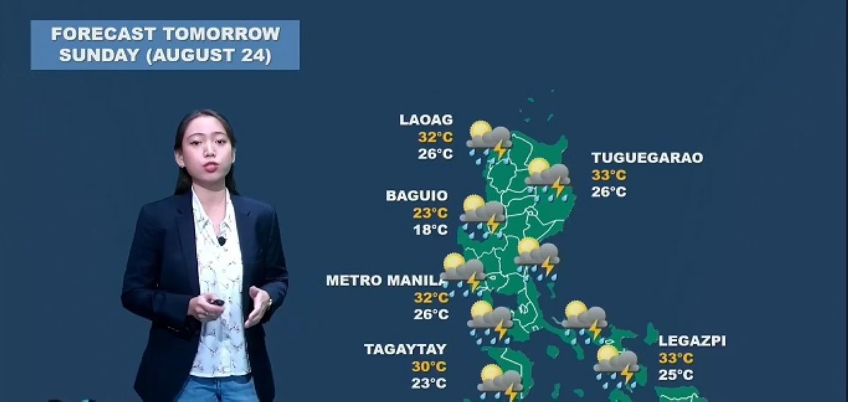
PAGASA forecasts fair weather in most of Luzon on August 24, 2025 with high temperatures in Metro Manila and northern cities, while Palawan, Visayas, and Mindanao are expected to experience rains due to a Low Pressure Area. (PAGASA / Facebook)
The Philippine Atmospheric, Geophysical and Astronomical Services Administration (PAGASA) forecasts generally fair weather across most of Luzon on Sunday, August 24, following the exit of Tropical Storm Isang (international name: Kajiki).
In a weather update on Saturday, August 23, PAGASA weather specialist Leanne Loreto said most of Luzon — including Metro Manila — can expect “generally fair” weather on August 24, except for isolated rain showers and thunderstorms in the afternoon or evening.
“Magiging maganda po ang ating panahon sa kabuuan ng Luzon, maliban sa mga tiyansa ng isolated o localized thunderstorms pagdating ng hapon at gabi (We will have generally fair weather across Luzon, except for chances of isolated or localized thunderstorms in the afternoon and evening),” Loreto said.
Due to the fair weather, PAGASA said residents can expect warm temperatures in major cities, with Metro Manila, Laoag, Tuguegarao, and Legazpi experiencing highs of 32 to 33 degrees Celsius.
LPA to bring rains in Visayas and Mindanao
While Luzon enjoys fair weather, PAGASA said a Low Pressure Area (LPA) east of Southern Mindanao will bring rain to Palawan, Eastern Visayas, and parts of Mindanao.
“Dahil nga po sa LPA, asahan natin ang maulap at maulan na panahon sa may eastern sections Visayas at sa Mindanao (Due to the LPA, we can expect cloudy and rainy weather over the eastern sections of Visayas and Mindanao),” Loreto said.
PAGASA said the LPA is forecasted to move northwestward from eastern Mindanao toward northeastern Mindanao, resulting in continuous rainfall in affected areas.
“Ito nga pong LPA ay aakyat at kililos papuntang north to northwestward, galing po sa may Silangan ng Mindanao paakyat sa may eastern Visayas (This LPA is moving north to northwestward, coming from the eastern part of Mindanao and heading toward eastern Visayas),” Loreto said.
“Lalapit po ito sa ating kalupaan, lalong-lalo na sa northeastern side ng Mindanao bukas kaya’t asahan ang tuloy-tuloy na pag-ulan (It will approach land, especially the northeastern side of Mindanao, by tomorrow—so continuous rainfall is expected),” she added.
Weather forecast
In its weather forecast issued at 4 p.m. on August 24, PAGASA said Tropical Storm Isang is located 600 km west of Sinait, Ilocos Sur, with maximum sustained winds of 85 km/h and gusts up to 105 km/h, moving westward at 30 km/h.
PAGASA is also monitoring the impacts of the southwest monsoon (habagat), which continues to affect western Central Luzon, Southern Luzon, and the Visayas.
The southwest monsoon is expected to bring cloudy skies with scattered rains and thunderstorms in Metro Manila, Central Luzon, Calabarzon, Mimaropa, and Antique. Partly cloudy to cloudy skies with isolated rain showers or thunderstorms are expected in the Negros Island Region and the rest of Western Visayas.
Meanwhile, the trough of Tropical Storm Isang will bring cloudy skies with scattered rains and thunderstorms in the Ilocos Region, Abra, and Benguet.
The trough of the LPA will bring similar conditions in Caraga, Davao Region, Northern Mindanao, Sarangani, Eastern Samar, Leyte, Southern Leyte, and Bohol, with partly cloudy to cloudy skies and isolated rain showers or thunderstorms in the rest of the country.
Partly cloudy to cloudy skies with isolated rain showers or thunderstorms are also expected in other parts of Luzon due to localized thunderstorms.
PAGASA warned of possible flash floods or landslides due to moderate to occasionally heavy rains or severe thunderstorms. Residents in affected areas are advised to stay alert for weather updates and flood warnings.