


Manila Bulletin
 Philippines
National
PAGASA: Tropical depression Isang continues to move across Northern Luzon
Philippines
National
PAGASA: Tropical depression Isang continues to move across Northern Luzon
Philippines
National
PAGASA: Tropical depression Isang continues to move across Northern Luzon
PAGASA: Tropical depression Isang continues to move across Northern Luzon
Published Aug 22, 2025 06:02 pm


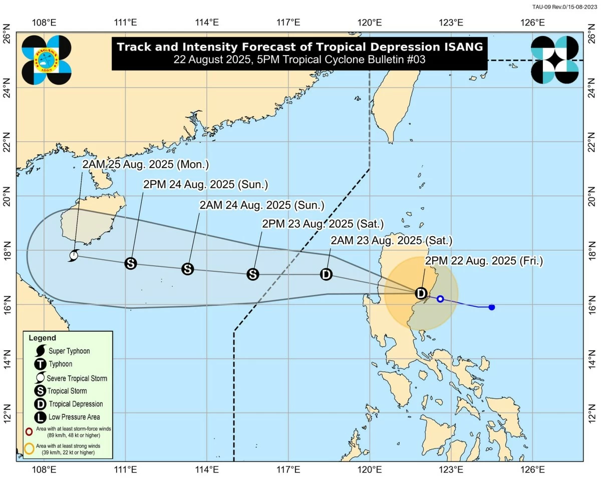
Forecast track and intensity of Tropical Depression Isang (PAGASA)
Tropical depression Isang slightly slowed down as it continued to cross Northern Luzon on Friday, Aug. 22, said the Philippine Atmospheric, Geophysical and Astronomical Services Administration (PAGASA).
As of 4 p.m., Isang was moving west-northwest at 15 kilometers per hour (kph) and was last located in the vicinity of Aglipay, Quirino.
It has maximum sustained winds of 55 kph near the center and gusts of up to 70 kph.
PAGASA said Isang is expected to continue traversing Northern Luzon and emerge over the West Philippine Sea on Friday evening.
It is projected to exit the Philippine Area of Responsibility (PAR) by Saturday afternoon or evening, Aug. 23.
Sixteen areas remain under Tropical Cyclone Wind Signal No. 1, including Cagayan, Isabela, Quirino, Nueva Vizcaya, Apayao, Kalinga, Abra, Mountain Province, Ifugao, Benguet, Ilocos Norte, Ilocos Sur, La Union, Pangasinan, Aurora, and the northern portion of Nueva Ecija (Lupao, Carranglan, Pantabangan, San Jose City).
Heavy rainfall is also expected to continue affecting parts of Luzon due to Isang and the enhanced southwest monsoon (habagat).
From Friday afternoon to Saturday afternoon, heavy to intense rainfall (100 to 200 millimeters) is expected in Zambales, Bataan, and Occidental Mindoro.
Meanwhile, moderate to heavy rainfall (50 to 100 mm) may persist in La Union, Pangasinan, Benguet, Pampanga, Quirino, Nueva Vizcaya, Aurora, Ifugao, Cagayan, Isabela, Nueva Ecija, Tarlac, Quezon, Metro Manila, Bulacan, Rizal, Laguna, Cavite, Batangas, Marinduque, Romblon, Oriental Mindoro, Palawan, Antique, and Aklan.
PAGASA said Isang may intensify into a tropical storm by Saturday morning and could reach the severe tropical storm category, while moving toward the waters south of Hainan, China.
However, it noted that earlier intensification upon reaching the West Philippine Sea remains possible.