


Manila Bulletin
 Philippines
National
'Isang' moves over West Philippine Sea; rains to persist in parts of Luzon due to tropical depression, 'habagat'
Philippines
National
'Isang' moves over West Philippine Sea; rains to persist in parts of Luzon due to tropical depression, 'habagat'
Philippines
National
'Isang' moves over West Philippine Sea; rains to persist in parts of Luzon due to tropical depression, 'habagat'
'Isang' moves over West Philippine Sea; rains to persist in parts of Luzon due to tropical depression, 'habagat'
Published Aug 22, 2025 11:35 pm


PAGASA
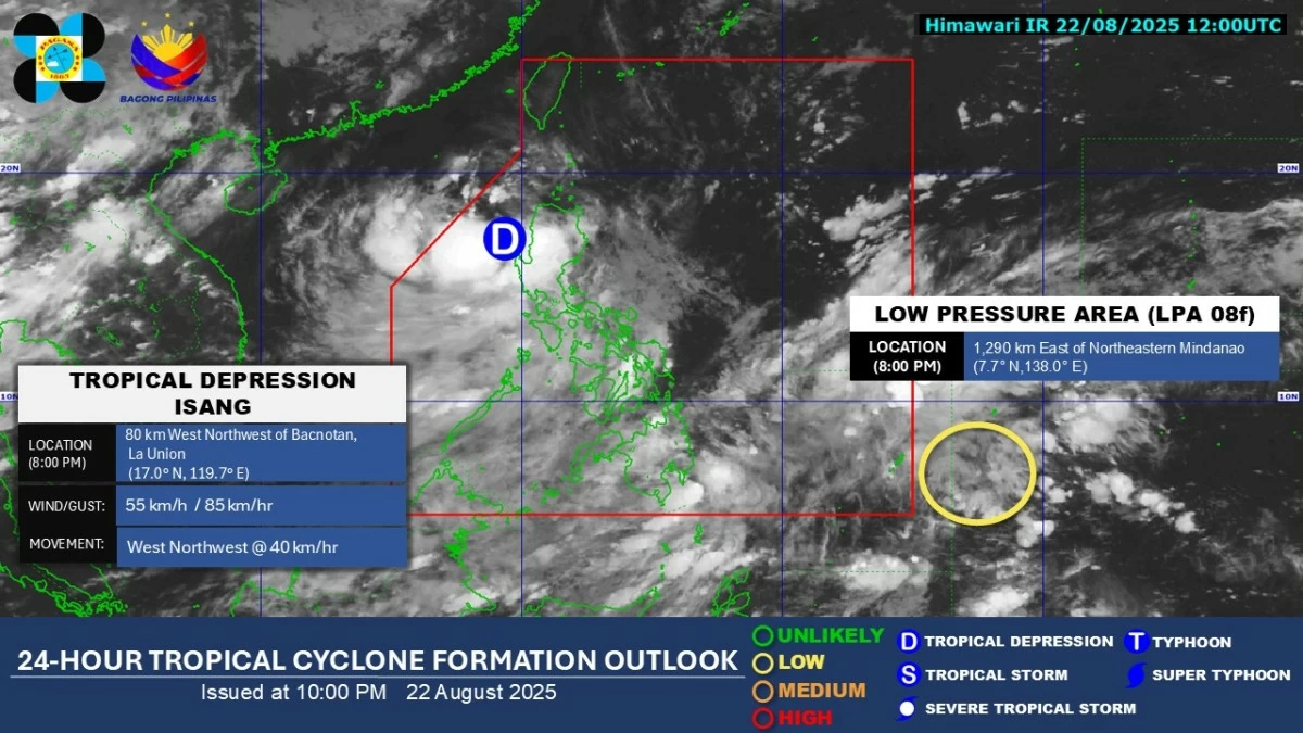
The Philippine Atmospheric, Geophysical and Astronomical Services Administration (PAGASA) said on Friday evening, Aug. 22, that tropical depression Isang had moved over the West Philippine Sea after crossing Northern Luzon in the past 12 hours.
As of 10 p.m., the center of the tropical depression was spotted 120 kilometers west-northwest of Bacnotan, La Union. It is moving west-northwest at 40 kilometers per hour (kph), with maximum sustained winds of 55 kph near the center and gusts of up to 85 kph.
Tropical Cyclone Wind Signal No. 1 remains hoisted over the following areas due to strong winds associated with Isang: Cagayan (including the Babuyan Islands), Isabela, Quirino, Nueva Vizcaya, Apayao, Abra, Kalinga, Mountain Province, Ifugao, Benguet, Ilocos Norte, Ilocos Sur, La Union, Pangasinan, and the northern portion of Nueva Ecija (Carranglan, Lupao).
PAGASA noted that minimal to minor impacts from strong winds may be expected in these areas.
In addition, heavy to intense rains (100-200 millimeters) may persist in Zambales, Bataan, and Occidental Mindoro due to Isang and the enhanced southwest monsoon (habagat).
Moderate to heavy rainfall (50-100 mm) is also likely in Ilocos Sur, La Union, Pangasinan, Benguet, Tarlac, Metro Manila, Pampanga, Bulacan, Cavite, Batangas, Marinduque, Oriental Mindoro, Romblon, Palawan, Aklan, and Antique.
Isang is expected to continue moving westward and may exit the Philippine Area of Responsibility (PAR) by Saturday morning or afternoon, Aug. 23.
PAGASA also said the tropical depression could intensify into a tropical storm by Saturday morning, with the potential to strengthen further into a severe tropical storm as it approaches the waters south of Hainan, China.
Meanwhile, a low-pressure area (LPA) was spotted outside the PAR, approximately 1,290 kilometers east of northeastern Mindanao as of 10 p.m.
PAGASA said the weather system has a low chance of developing into a tropical cyclone within the next 24 hours.