


Manila Bulletin
 Philippines
National
'Huaning' leaves PAR; another LPA may develop into tropical cyclone
Philippines
National
'Huaning' leaves PAR; another LPA may develop into tropical cyclone
Philippines
National
'Huaning' leaves PAR; another LPA may develop into tropical cyclone
'Huaning' leaves PAR; another LPA may develop into tropical cyclone
Published Aug 19, 2025 09:52 am
|
Updated Aug 19, 2025 01:31 pm


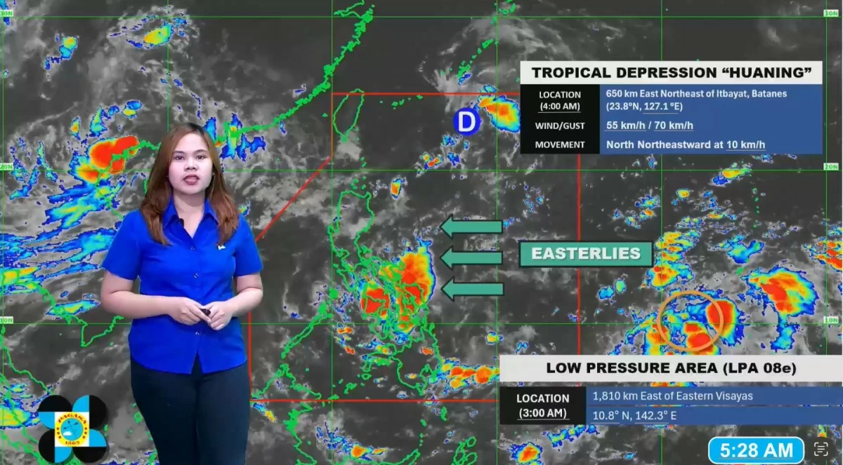
Philippine Atmospheric, Geophysical and Astronomical Services Administration (PAGASA) weather specialist Chenel Dominguez provides updates on tropical depression Huaning and a new low-pressure area east of Visayas. (Screengrab from PAGASA/Facebook)
Tropical depression “Huaning” exited the Philippine Area of Responsibility (PAR) at 5 a.m. on Tuesday, Aug. 19, but the Philippine Atmospheric, Geophysical and Astronomical Services Administration (PAGASA) is now monitoring a new low-pressure area (LPA) east of Visayas that could become a tropical cyclone in the coming days.
PAGASA weather specialist Chenel Dominguez said Huaning is expected to continue moving away from the country and is unlikely to directly affect the country or enhance the southwest monsoon (habagat).
Meanwhile, an LPA was spotted outside the PAR, 1,810 kilometers east of Eastern Visayas, and has a “medium” chance of developing into a tropical cyclone within the next 24 hours.
“Meaning mababa ang tyansa nito maging bagyo within the next 24 oras pero sa mga susunod na araw hindi natin inaalis ang posibilidad na maging bagyo ito (This means it has a low chance of developing into a cyclone within the next 24 hours, but in the coming days, we are not ruling out the possibility that it could intensify),” Dominguez said.
“Sa nakikita natin, forecast track nito possible lumapit ito sa Northern Luzon at magdadala rin ito ng mga pag-ulan lalo na dito sa eastern section ng Luzon (Based on current observations, its forecast track may bring it closer to Northern Luzon and may bring rains, especially over the eastern section of Luzon),” she added.
However, Dominguez said uncertainty remains high with the LPA and advised the public to stay updated on the latest weather information.
If the system intensifies into a tropical cyclone, it will be named “Isang,” the next name on PAGASA’s list.
Currently, easterlies, or warm winds from the Pacific Ocean, are prevailing over Southern Luzon, Visayas, and Mindanao, bringing increased chances of rain in several areas, Dominguez said.
Scattered rains may prevail over the Visayas, Bicol Region, Mimaropa, Zamboanga Peninsula, Northern Mindanao, Caraga, Davao Region, and Quezon province.
The rest of Mindanao is expected to experience partly cloudy to cloudy skies with isolated rain showers or thunderstorms.
Meanwhile, the rest of the country may have generally fair weather, with isolated rain showers in the afternoon or evening due to localized thunderstorms.
PAGASA reminded the public to remain vigilant against possible flash floods and landslides during moderate to heavy rainfall or severe thunderstorms.