


Manila Bulletin
 Philippines
National
New LPA forms inside PAR, has 'medium' chance of developing into tropical cyclone — PAGASA
Philippines
National
New LPA forms inside PAR, has 'medium' chance of developing into tropical cyclone — PAGASA
Philippines
National
New LPA forms inside PAR, has 'medium' chance of developing into tropical cyclone — PAGASA
New LPA forms inside PAR, has 'medium' chance of developing into tropical cyclone — PAGASA
Published Aug 17, 2025 05:14 pm


PAGASA
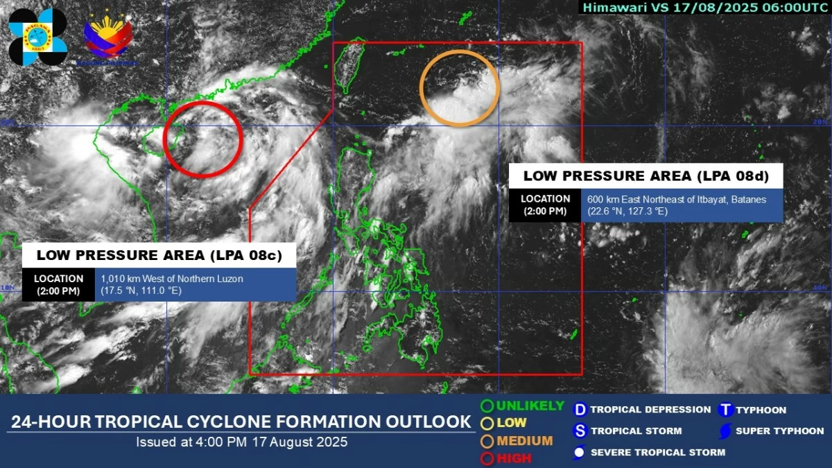
The Philippine Atmospheric, Geophysical and Astronomical Services Administration (PAGASA) said a low-pressure area (LPA) developed inside the Philippine Area of Responsibility (PAR) on Sunday afternoon, Aug. 17.
PAGASA weather specialist Charmagne Varilla said the LPA was located 585 kilometers east-northeast of Itbayat, Batanes, as of 3 p.m.
Varilla said the weather disturbance has a “medium” chance of developing into a tropical depression within the next 48 hours.
Should it intensify while inside the PAR, it will be named “Huaning.”
The other LPA being monitored outside PAR, located 1,010 kilometers west of Northern Luzon, has a high likelihood of becoming a tropical cyclone.
However, it is moving westward, away from the country.
As of Sunday afternoon, Varilla said the trough or extension of the two LPAs is expected to bring cloudy skies with scattered rains and thunderstorms over Ilocos Region, Apayao, Cagayan, Zambales, and Bataan.
Metro Manila, Cavite, Batangas, Occidental Mindoro, and Palawan may also experience similar conditions due to the southwest monsoon or “habagat,” enhanced by the LPA outside the PAR.
The rest of the country will experience partly cloudy to cloudy skies with isolated rain showers due to localized thunderstorms.
PAGASA advised the public to remain vigilant for possible flash floods and landslides, especially during moderate to heavy rainfall or severe thunderstorms.