


Manila Bulletin
 Philippines
National
Severe tropical storm east of extreme N. Luzon unlikely to directly affect Philippines — PAGASA
Philippines
National
Severe tropical storm east of extreme N. Luzon unlikely to directly affect Philippines — PAGASA
Philippines
National
Severe tropical storm east of extreme N. Luzon unlikely to directly affect Philippines — PAGASA
Severe tropical storm east of extreme N. Luzon unlikely to directly affect Philippines — PAGASA
Published Aug 10, 2025 09:44 am
|
Updated Aug 10, 2025 01:14 pm


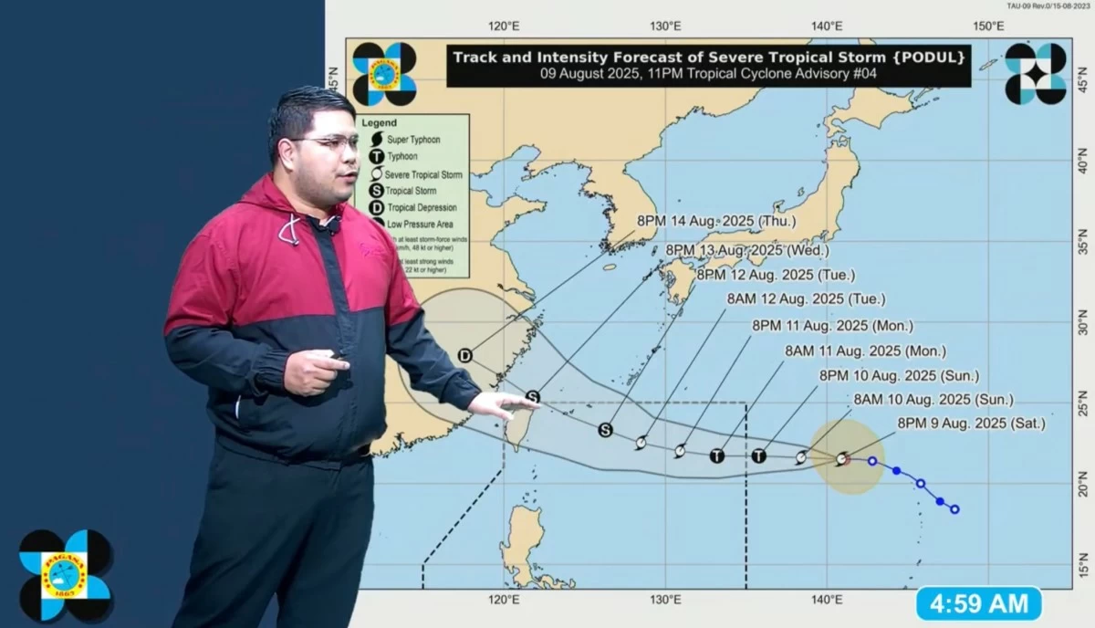
Philippine Atmospheric, Geophysical and Astronomical Services Administration (PAGASA) weather specialist Obet Badrina shows the potential track of Severe Tropical Storm Podul during the public weather forecast on Sunday, Aug. 10, 2025. (PAGASA/Facebook)
The Philippine Atmospheric, Geophysical and Astronomical Services Administration (PAGASA) said the severe tropical storm, internationally known as “Podul,” is expected to enter the Philippine Area of Responsibility (PAR) on Sunday evening, Aug. 10 or early Monday, Aug. 11, but may not have a direct impact on the country.
Once it enters PAR, the storm will be given the local name “Gorio.”
At 3 a.m. Sunday, Podul was located 1,875 kilometers east of extreme Northern Luzon.
It was moving westward at 15 kilometers per hour (kph), with maximum sustained winds of 110 kph and gusts of up to 135 kph.
PAGASA weather specialist Obet Badrina said Podul is expected to stay in the northeastern section of PAR from Monday to Tuesday, Aug. 12.
It may make landfall over Taiwan by Wednesday, Aug. 13, before exiting the country’s monitoring area.
Badrina said latest data show that the weather disturbance is unlikely significantly affect any part of the country.
However, if Podul shifts southward, tropical cyclone wind signals could be raised in parts of Batanes, he added.
The storm is also unlikely to strengthen the southwest monsoon (habagat). Generally fair weather can be expected across most of the country in the coming days.
On Monday, isolated rain showers and thunderstorms are possible. However, overall weather conditions are expected to remain generally fair across the country.
From Tuesday to Wednesday, the habagat may bring scattered rain showers and thunderstorms over the western parts of Visayas and Mindanao.
By Thursday, Aug. 14, scattered rain showers may affect most of Visayas, Mindanao, and parts of Southern Luzon.
PAGASA advised the public to remain alert for possible flash floods and landslides, especially during moderate to heavy rainfall or severe thunderstorms.