


LPA outside PAR develops into tropical depression — PAGASA
To be named 'Fabian' upon entry into PAR
Published Aug 7, 2025 05:45 pm


PAGASA
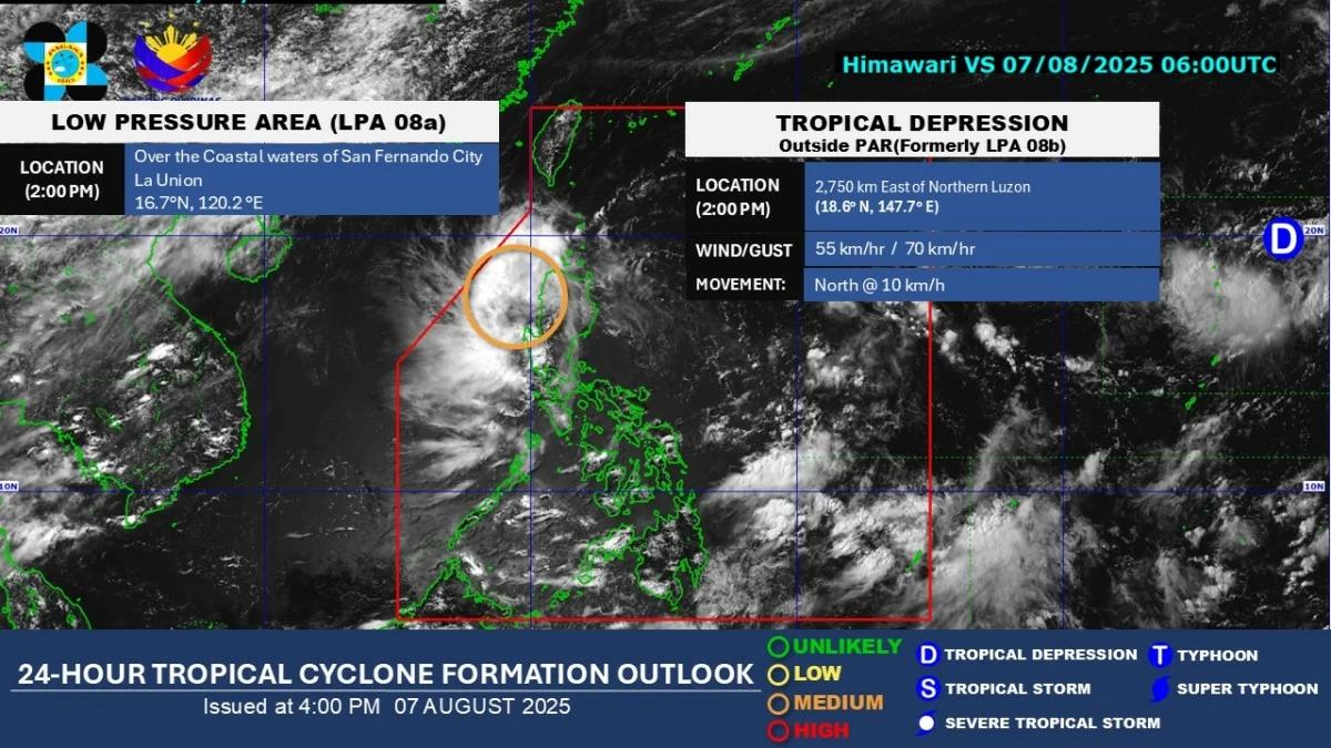
The Philippine Atmospheric, Geophysical and Astronomical Services Administration (PAGASA) on Thursday afternoon, Aug. 7 said the low-pressure area (LPA) spotted outside the Philippine area of responsibility (PAR) has intensified into a tropical depression.
PAGASA weather specialist Leanne Loreto said the weather disturbance, located 2,730 kilometers east of Northern Luzon, currently has no direct effect on the country.
However, it is expected to move west into the Philippine Sea and may enter the PAR in the coming days.
If it remains a tropical cyclone upon entry, it will be named “Fabian.”
Meanwhile, the LPA within the PAR was located over the coastal waters of San Fernando City, La Union, on Thursday afternoon.
Loreto said it is moving westward and may exit the PAR between Friday, Aug. 8, and Saturday, Aug. 9.
In the next 24 hours, this LPA is expected to continue bringing scattered to widespread rains and thunderstorms over Ilocos Region and Zambales.
Scattered rains and thunderstorms may also affect Metro Manila, Cordillera Administrative Region, Cagayan Valley, Central Luzon, Cavite, Laguna, Batangas, Rizal Quezon, Occidental Mindoro, Oriental Mindoro, Marinduque, Romblon, Albay, Sorsogon, and Masbate.
Meanwhile, the southwest monsoon or “habagat” may bring scattered rains and thunderstorms over Visayas, Zamboanga Peninsula, Northern Mindanao, Caraga, Palawan, and Davao Oriental.
The rest of the country may experience partly cloudy to cloudy skies with isolated rain showers or thunderstorms.
PAGASA advised the public to remain alert for possible flash floods and landslides, especially during moderate to heavy rainfall or severe thunderstorms.