


Manila Bulletin
 Philippines
National
LPA develops into tropical depression; now less likely to enter PAR — PAGASA
Philippines
National
LPA develops into tropical depression; now less likely to enter PAR — PAGASA
Philippines
National
LPA develops into tropical depression; now less likely to enter PAR — PAGASA
LPA develops into tropical depression; now less likely to enter PAR — PAGASA
Published Aug 1, 2025 05:36 pm


PAGASA
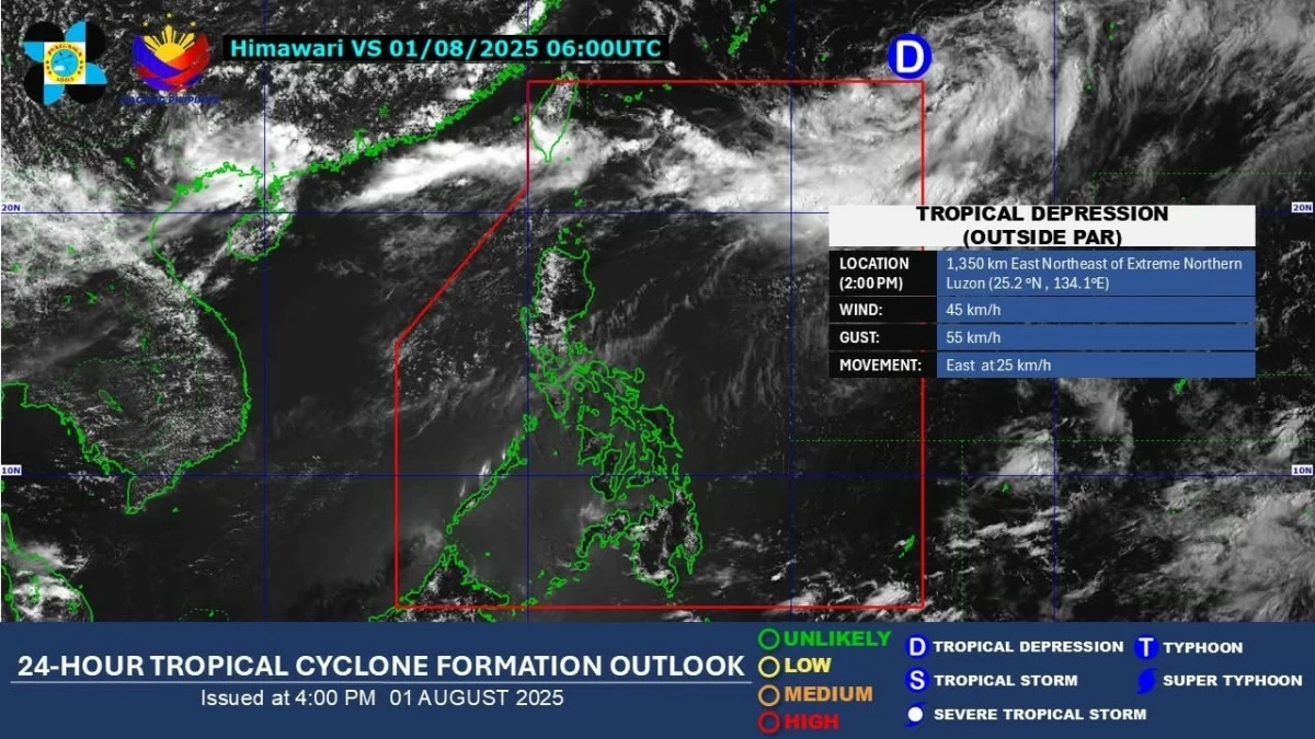
The low-pressure area (LPA) outside the Philippine Area of Responsibility (PAR) has intensified into a tropical depression but is now less likely to enter the country’s monitoring domain, the Philippine Atmospheric, Geophysical and Astronomical Services Administration (PAGASA) said on Friday afternoon, Aug. 1.
As of 3 p.m., the tropical depression was located 1,365 kilometers east-northeast of extreme Northern Luzon.
It has maximum sustained winds of 45 kilometers per hour (kph) near the center and gusts of up to 55 kph.
It is moving eastward at 25 kph.
PAGASA weather specialist Benison Estareja said the tropical depression is currently over the northern Philippine Sea and is expected to move northeastward, away from the country, by Saturday, Aug. 2.
“There is only a slim chance that this tropical depression will enter PAR,” he said.
Estareja added that the weather system is not expected to have any direct impact on the country and is not enhancing the southwest monsoon or habagat.
He said the habagat continues to weaken and is currently affecting only parts of Northern Luzon, particularly Ilocos Norte, Ilocos Sur, Abra, Batanes, and Babuyan Islands.
These areas may experience cloudy skies with scattered light to heavy rains and thunderstorms.
Meanwhile, Metro Manila and the rest of Luzon will experience partly cloudy to cloudy skies with isolated rain showers or thunderstorms.
Similar weather conditions are expected across Visayas and Mindanao due to localized thunderstorms.