


Manila Bulletin
 Philippines
National
'Emong' weakens over Cordillera, heads for exit as storm signals, coastal hazards persist
Philippines
National
'Emong' weakens over Cordillera, heads for exit as storm signals, coastal hazards persist
Philippines
National
'Emong' weakens over Cordillera, heads for exit as storm signals, coastal hazards persist
'Emong' weakens over Cordillera, heads for exit as storm signals, coastal hazards persist
PAGASA monitors two tropical cyclones outside PAR
Published Jul 25, 2025 11:40 am
|
Updated Jul 25, 2025 01:21 pm


At A Glance
- Severe Tropical Storm "Emong" continues to weaken over the Cordillera Central and is expected to exit Luzon via the Babuyan Channel toward the East China Sea
- Despite weakening, PAGASA warns of strong winds, heavy rain, possible flooding, and landslides in Northern Luzon, especially in areas under TCWS Nos. 1–3. Storm surges (1.0–3.0 meters) and rough seas may affect coastal areas, with a gale warning in effect
- PAGASA is also monitoring Tropical Storms Francisco (formerly 'Dante') and Krosa outside the Philippine Area of Responsibility
Severe Tropical Storm Emong weakens over the Cordillera but continues to bring heavy rain, strong winds, and storm surges. (PAGASA)
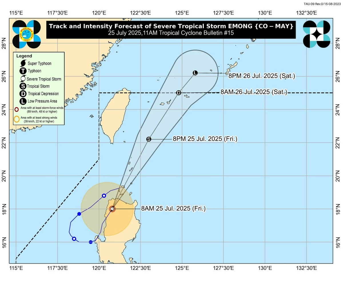
Severe Tropical Storm Emong (international name: Co-may) continues to weaken as it traverses the Cordillera Central and is now poised to exit the Luzon landmass via the Babuyan Channel, according to the Philippine Atmospheric, Geophysical and Astronomical Services Administration (PAGASA).
In its 11 a.m. bulletin issued on Friday, July 25, PAGASA said “Emong” is moving north-northeast at 40 km/h, carrying maximum sustained winds of 95 km/h near the center and gusts of up to 160 km/h.
The storm is forecast to pass near or over the Babuyan Islands and Batanes before exiting the Philippine Area of Responsibility (PAR).
Strong winds, rainfall still a threat
Despite weakening, PAGASA said “Emong” remains a threat to northern Luzon due to strong winds and heavy rainfall intensified by the southwest monsoon (habagat).
Areas under Tropical Cyclone Wind Signals (TCWS) are still expected to experience varying levels of damage:
- Signal No. 3 (up to 117 km/h winds): The northeastern portion of Ilocos Norte (Bangui, Pagudpud, Dumalneg, Piddig, Vintar, Adams, Carasi), the northern portion of Apayao (Calanasan, Luna), and the northwestern portion of mainland Cagayan (Santa Praxedes, Claveria, Sanchez-Mira, Pamplona).
- Signal No. 2 (up to 88 km/h): The rest of Ilocos Norte; the northern portion of Ilocos Sur (Santa, Caoayan, City of Vigan, Bantay, Santa Catalina, San Vicente, Santo Domingo, San Ildefonso, Magsingal, San Juan, Cabugao, Sinait); the rest of Apayao; the northern portion of Abra (Pidigan, San Juan, Tayum, Langiden, Sallapadan, Lagangilang, Danglas, La Paz, Licuan-Baay, Tineg, Malibcong, Peñarrubia, San Isidro, San Quintin, Dolores, Lagayan, Bangued, Bucay, Lacub); Batanes; and the northern and western portions of mainland Cagayan (Piat, Camalaniugan, Tuao, Buguey, Aparri, Allacapan, Rizal, Lasam, Ballesteros, Abulug, Santo Niño).
- Signal No. 1 (up to 61 km/h): The rest of Ilocos Sur; the northern portion of La Union (Luna, Santol, City of San Fernando, San Juan, Bagulin, Bangar, San Gabriel, Bacnotan, Sudipen, Balaoan); the rest of Abra; the northern portion of Benguet (Mankayan, Kapangan, Atok, Kabayan, Kibungan, Bakun, Buguias); Kalinga, Mountain Province, Ifugao; the rest of mainland Cagayan; and the northern portion of Isabela (Quirino, Mallig, Quezon, Delfin Albano, Tumauini, Maconacon, San Pablo, Santa Maria, Cabagan, Santo Tomas, Roxas, San Manuel).
PAGASA warned of moderate to heavy rains across the Cordillera, Cagayan Valley, and portions of Central and Southern Luzon, with possible flooding and landslides.
The enhanced monsoon is also bringing rain to the Visayas and parts of Mindanao, according to PAGASA.
Life-threatening storm surge, rough seas
PAGASA said a storm surge warning is in effect for coastal areas in Batanes, the Babuyan Islands, Cagayan, Isabela, Ilocos Norte and Sur, La Union, Pangasinan, and Zambales. Peak surge heights may reach 1.0 to 3.0 meters in low-lying communities.
A gale warning has also been raised over the seaboards of Northern Luzon and the western seaboards of Central and Southern Luzon, where sea conditions could be extremely hazardous, with wave heights reaching up to 9.0 meters in some areas.
PAGASA has advised all types of vessels to remain in port, warning that sea travel is extremely dangerous, especially for small boats and motorbancas.
Emong’s projected path, dissipation
By 8 p.m. tonight, July 25, PAGASA said “Emong” is forecast to be 200 km northeast of Itbayat, Batanes. It is expected to be outside PAR by the morning of Friday, July 26, continuing to weaken and eventually degenerating into a low-pressure area as it moves into the East China Sea.
“Emong will continue to weaken throughout the forecast period due to an increasingly unfavorable environment,” PAGASA said.
The weather bureau said "Emong“ will likely "degenerate into a remnant low" by evening of July 26 while entering the East China Sea. "However, a slightly faster weakening trend is not ruled out,” it added.
Tropical cyclone update
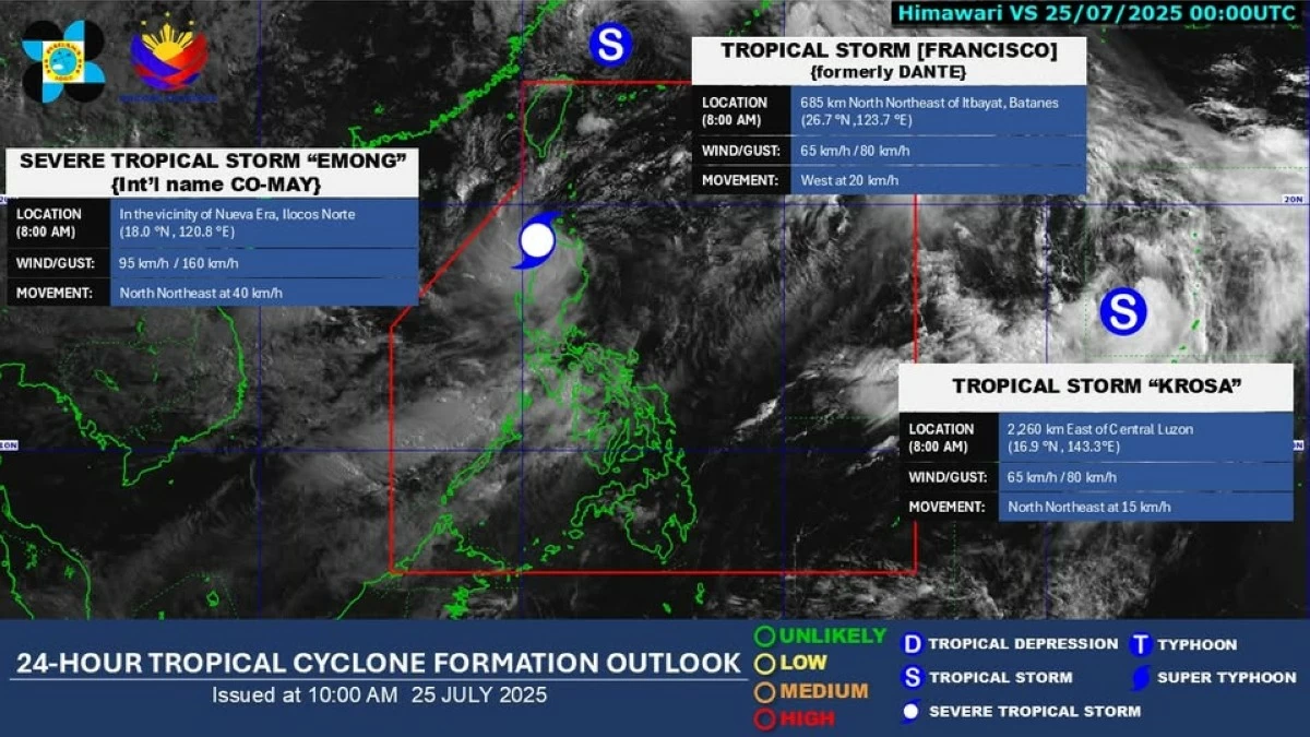
Aside from 'Emong,' which is currently inside the Philippine Area of Responsibility (PAR), PAGASA is also monitoring two tropical cyclones—Francisco (formerly 'Dante') and Krosa—both currently outside the PAR. (PAGASA)
As of 8 a.m., PAGASA said "Emong" has been downgraded to a severe tropical storm and is being monitored inside the PAR.
Meanwhile, two cyclones — Tropical Storm Francisco (formerly "Dante") and Tropical Storm Krosa — are also being monitored outside PAR.