ADVERTISEMENT

'Emong' weakens after second landfall over Ilocos Sur, says PAGASA

Published Jul 25, 2025 08:34 am
PAGASA
PAGASA
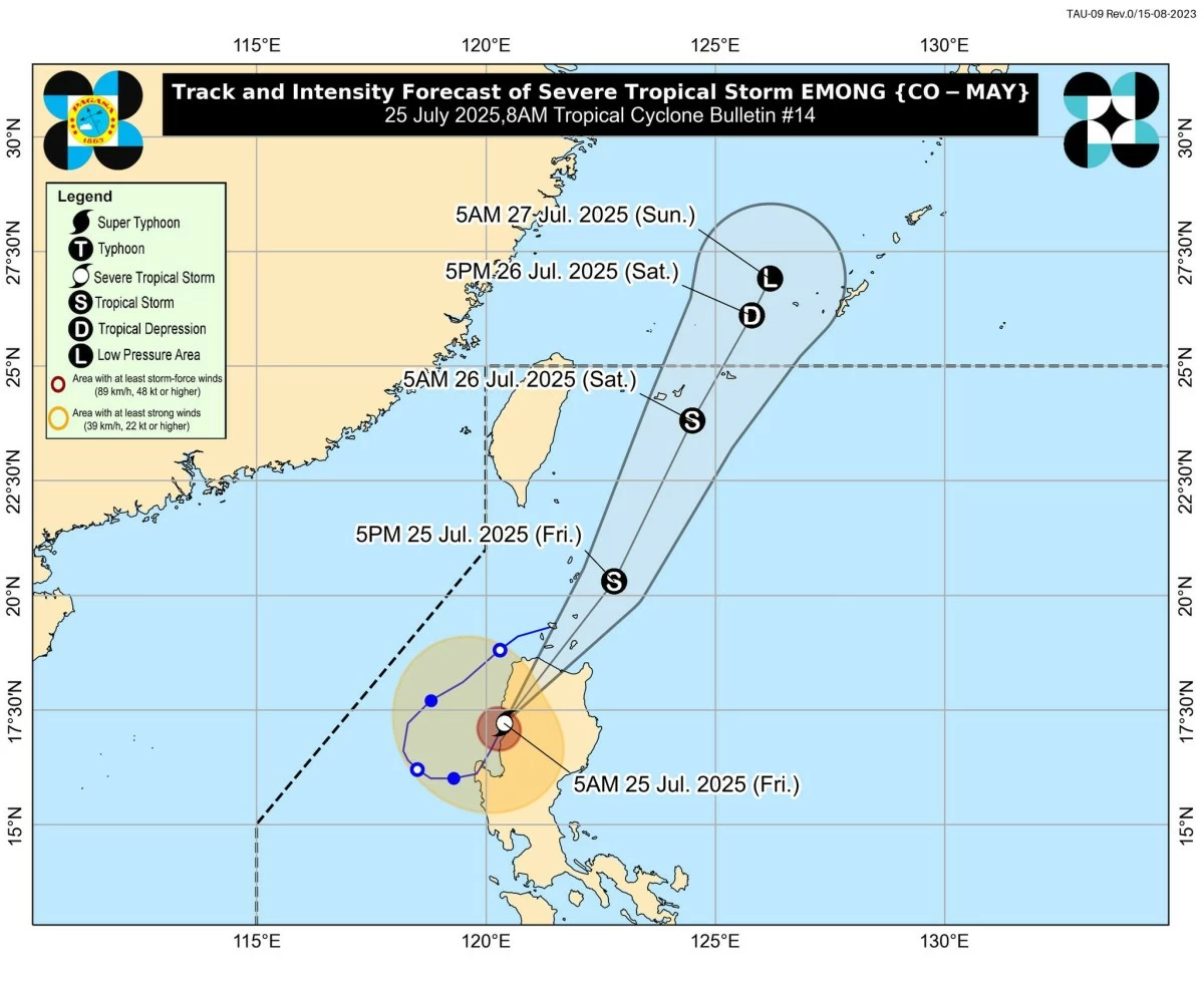
The Philippine Atmospheric, Geophysical and Astronomical Services Administration (PAGASA) said Typhoon Emong (international name: Co-may) made its second landfall over Candon City, Ilocos Sur, at around 5:10 a.m. on Friday, July 25.
Emong first made landfall over Agno, Pangasinan, on Thursday evening, July 24.
As of 7 a.m., PAGASA located the center of Emong over San Isidro, Abra.
It is expected to continue moving across Northern Luzon’s mountainous terrain and could emerge over the Babuyan Channel by noon.
From there, Emong will move northeastward and pass close or directly over the Babuyan Islands between noon and afternoon.
It may also pass near Batanes later this afternoon or evening before continuing its north-northeastward track until it exits the Philippine Area of Responsibility (PAR) by Saturday morning or noon, July 26.
After traversing the Cordillera mountain range, PAGASA said Emong weakened from a typhoon into a severe tropical storm, with maximum sustained winds of 100 kilometers per hour (kph) and gusts of up to 165 kph.
PAGASA expects it to further weaken into a tropical storm within the day due to land interaction and to continue weakening throughout the forecast period.
After Emong weakened, PAGASA has downgraded the tropical cyclone wind signals in several areas as of Friday morning.
Signal No. 3 was hoisted over Ilocos Norte, Ilocos Sur, northern portion of La Union (Bangar, Sudipen, Balaoan, Luna, Santol, Bacnotan, San Gabriel, Bagulin, San Juan, City of San Fernando), Apayao, Abra, western portion of Kalinga (Balbalan, Pasil, Tinglayan, Lubuagan), western portion of Mountain Province (Besao, Tadian, Sagada, Bauko, Sabangan, Bontoc, Sadanga), northwestern portion of Benguet (Mankayan, Bakun, Kibungan, Kapangan), and northern and western portions of Cagayan (Santa Praxedes, Claveria, Sanchez-Mira, Pamplona, Abulug, Ballesteros, Rizal, Lasam, Allacapan, Aparri).
Meanwhile, Signal No. 2 is in effect over Batanes, the rest of mainland Cagayan, including Babuyan Islands, northern and western portions of Isabela (Cordon, City of Santiago, Ramon, San Isidro, Alicia, San Mateo, Cabatuan, San Manuel, Luna, Aurora, Burgos, Roxas, Quirino, Mallig, Delfin Albano, Quezon, Cabagan, Santa Maria, San Pablo, Maconacon, Santo Tomas, Tumauini, Gamu, Ilagan City, City of Cauayan, Reina Mercedes, Naguilian), northwestern portion of Quirino (Diffun), western and central portions of Nueva Vizcaya (Kayapa, Santa Fe, Ambaguio, Aritao, Bambang, Bayombong, Villaverde, Solano, Bagabag, Dupax del Sur, Dupax del Norte, Kasibu, Quezon, Diadi), the rest of Kalinga, the rest of Mountain Province, Ifugao, the rest of Benguet, the rest of La Union, and northwestern portion of Pangasinan (Bolinao, Anda).
Signal No. 1 is raised over the rest of Pangasinan, the rest of Isabela, the rest of Quirino, the rest of Nueva Vizcaya, northern and central portions of Aurora (Dilasag, Casiguran, Dinalungan, Dipaculao), northern portion of Nueva Ecija (Nampicuan, Cuyapo, Guimba, Talugtug, Science City of Muñoz, San Jose City, Lupao, Carranglan, Pantabangan), northern portion of Tarlac (San Clemente, Camiling, Moncada, San Manuel, Anao, Paniqui, Santa Ignacia, Mayantoc, San Jose, City of Tarlac, Victoria, Pura, Gerona, Ramos), and northern portion of Zambales (Santa Cruz, Candelaria, Masinloc, Palauig, Iba).
“Moderate to significant” impacts from storm-force winds are possible in areas where Signal No. 3 is currently in effect.
In areas under Signal No. 2, “minor to moderate” impacts from gale-force winds may be experienced.
Meanwhile, “minimal to minor” impacts from strong winds are expected in areas under Signal No. 1.
Due to Typhoon Emong and the enhanced southwest monsoon (habagat), intense to torrential rains (over 200 millimeters) are expected to prevail over Ilocos Sur, Ilocos Norte, La Union, Pangasinan, Abra, Benguet, and Occidental Mindoro.
Heavy to intense rainfall (100 to 200 millimeters) is expected to persist in Batanes, Cagayan, Apayao, Mountain Province, Ifugao, Kalinga, Zambales, Bataan, Pampanga, Tarlac, and Laguna.
Meanwhile, moderate to heavy rainfall (50 to 100 millimeters) is expected to affect Isabela, Nueva Vizcaya, Nueva Ecija, Metro Manila, Bulacan, Rizal, Quezon, Aurora, Quirino, Oriental Mindoro, Palawan, Marinduque, Romblon, Camarines Norte, Camarines Sur, Albay, and Antique.
PAGASA advised residents, particularly in low-lying and mountainous areas, to remain vigilant against possible flash floods and landslides.

Related Tags

PAGASA SIGNAL NO. 3 LANDFALL TYPHOON EMONG HABAGAT
ADVERTISEMENT
.most-popular .layout-ratio{ padding-bottom: 79.13%; } @media (min-width: 768px) and (max-width: 1024px) { .widget-title { font-size: 15px !important; } }

{{ articles_filter_1561_widget.title }}

.most-popular .layout-ratio{ padding-bottom: 79.13%; } @media (min-width: 768px) and (max-width: 1024px) { .widget-title { font-size: 15px !important; } }

{{ articles_filter_1562_widget.title }}

.most-popular .layout-ratio{ padding-bottom: 79.13%; } @media (min-width: 768px) and (max-width: 1024px) { .widget-title { font-size: 15px !important; } }

{{ articles_filter_1563_widget.title }}

{{ articles_filter_1564_widget.title }}

.mb-article-details { position: relative; } .mb-article-details .article-body-preview, .mb-article-details .article-body-summary{ font-size: 17px; line-height: 30px; font-family: "Libre Caslon Text", serif; color: #000; } .mb-article-details .article-body-preview iframe , .mb-article-details .article-body-summary iframe{ width: 100%; margin: auto; } .read-more-background { background: linear-gradient(180deg, color(display-p3 1.000 1.000 1.000 / 0) 13.75%, color(display-p3 1.000 1.000 1.000 / 0.8) 30.79%, color(display-p3 1.000 1.000 1.000) 72.5%); position: absolute; height: 200px; width: 100%; bottom: 0; display: flex; justify-content: center; align-items: center; padding: 0; } .read-more-background a{ color: #000; } .read-more-btn { padding: 17px 45px; font-family: Inter; font-weight: 700; font-size: 18px; line-height: 16px; text-align: center; vertical-align: middle; border: 1px solid black; background-color: white; } .hidden { display: none; }
function initializeAllSwipers() { // Get all hidden inputs with cms_article_id document.querySelectorAll('[id^="cms_article_id_"]').forEach(function (input) { const cmsArticleId = input.value; const articleSelector = '#article-' + cmsArticleId + ' .body_images'; const swiperElement = document.querySelector(articleSelector); if (swiperElement && !swiperElement.classList.contains('swiper-initialized')) { new Swiper(articleSelector, { loop: true, pagination: false, navigation: { nextEl: '#article-' + cmsArticleId + ' .swiper-button-next', prevEl: '#article-' + cmsArticleId + ' .swiper-button-prev', }, }); } }); } setTimeout(initializeAllSwipers, 3000); const intersectionObserver = new IntersectionObserver( (entries) => { entries.forEach((entry) => { if (entry.isIntersecting) { const newUrl = entry.target.getAttribute("data-url"); if (newUrl) { history.pushState(null, null, newUrl); let article = entry.target; // Extract metadata const author = article.querySelector('.author-section').textContent.replace('By', '').trim(); const section = article.querySelector('.section-info ').textContent.replace(' ', ' '); const title = article.querySelector('.article-title h1').textContent; // Parse URL for Chartbeat path format const parsedUrl = new URL(newUrl, window.location.origin); const cleanUrl = parsedUrl.host + parsedUrl.pathname; // Update Chartbeat configuration if (typeof window._sf_async_config !== 'undefined') { window._sf_async_config.path = cleanUrl; window._sf_async_config.sections = section; window._sf_async_config.authors = author; } // Track virtual page view with Chartbeat if (typeof pSUPERFLY !== 'undefined' && typeof pSUPERFLY.virtualPage === 'function') { try { pSUPERFLY.virtualPage({ path: cleanUrl, title: title, sections: section, authors: author }); } catch (error) { console.error('ping error', error); } } // Optional: Update document title if (title && title !== document.title) { document.title = title; } } } }); }, { threshold: 0.1 } ); function showArticleBody(button) { const article = button.closest("article"); const summary = article.querySelector(".article-body-summary"); const body = article.querySelector(".article-body-preview"); const readMoreSection = article.querySelector(".read-more-background"); // Hide summary and read-more section summary.style.display = "none"; readMoreSection.style.display = "none"; // Show the full article body body.classList.remove("hidden"); } document.addEventListener("DOMContentLoaded", () => { let loadCount = 0; // Track how many times articles are loaded const offset = [1, 2, 3, 4, 5, 6, 7, 8, 9, 10]; // Offset values const currentUrl = window.location.pathname.substring(1); let isLoading = false; // Prevent multiple calls if (!currentUrl) { console.log("Current URL is invalid."); return; } const sentinel = document.getElementById("load-more-sentinel"); if (!sentinel) { console.log("Sentinel element not found."); return; } function isSentinelVisible() { const rect = sentinel.getBoundingClientRect(); return ( rect.top < window.innerHeight && rect.bottom >= 0 ); } function onScroll() { if (isLoading) return; if (isSentinelVisible()) { if (loadCount >= offset.length) { console.log("Maximum load attempts reached."); window.removeEventListener("scroll", onScroll); return; } isLoading = true; const currentOffset = offset[loadCount]; window.loadMoreItems().then(() => { let article = document.querySelector('#widget_1690 > div:nth-last-of-type(2) article'); intersectionObserver.observe(article) loadCount++; }).catch(error => { console.error("Error loading more items:", error); }).finally(() => { isLoading = false; }); } } window.addEventListener("scroll", onScroll); });

Sign up by email to receive news.