


Manila Bulletin
 Philippines
National
'Emong' maintains strength as it nears Luzon; storm surge threatens coastal areas
Philippines
National
'Emong' maintains strength as it nears Luzon; storm surge threatens coastal areas
Philippines
National
'Emong' maintains strength as it nears Luzon; storm surge threatens coastal areas
'Emong' maintains strength as it nears Luzon; storm surge threatens coastal areas
Published Jul 24, 2025 02:41 pm


At A Glance
- Typhoon Emong nears Luzon with Signal No. 3 raised in several areas
- PAGASA warns of strong winds, heavy rain, storm surges up to 3 meters, and dangerous sea conditions
‘EMONG’ NEARS LUZON: PAGASA warns of strong winds, heavy rain, and up to 3-meter storm surges as Signal No. 3 is raised in parts of Northern and Central Luzon. (PAGASA)
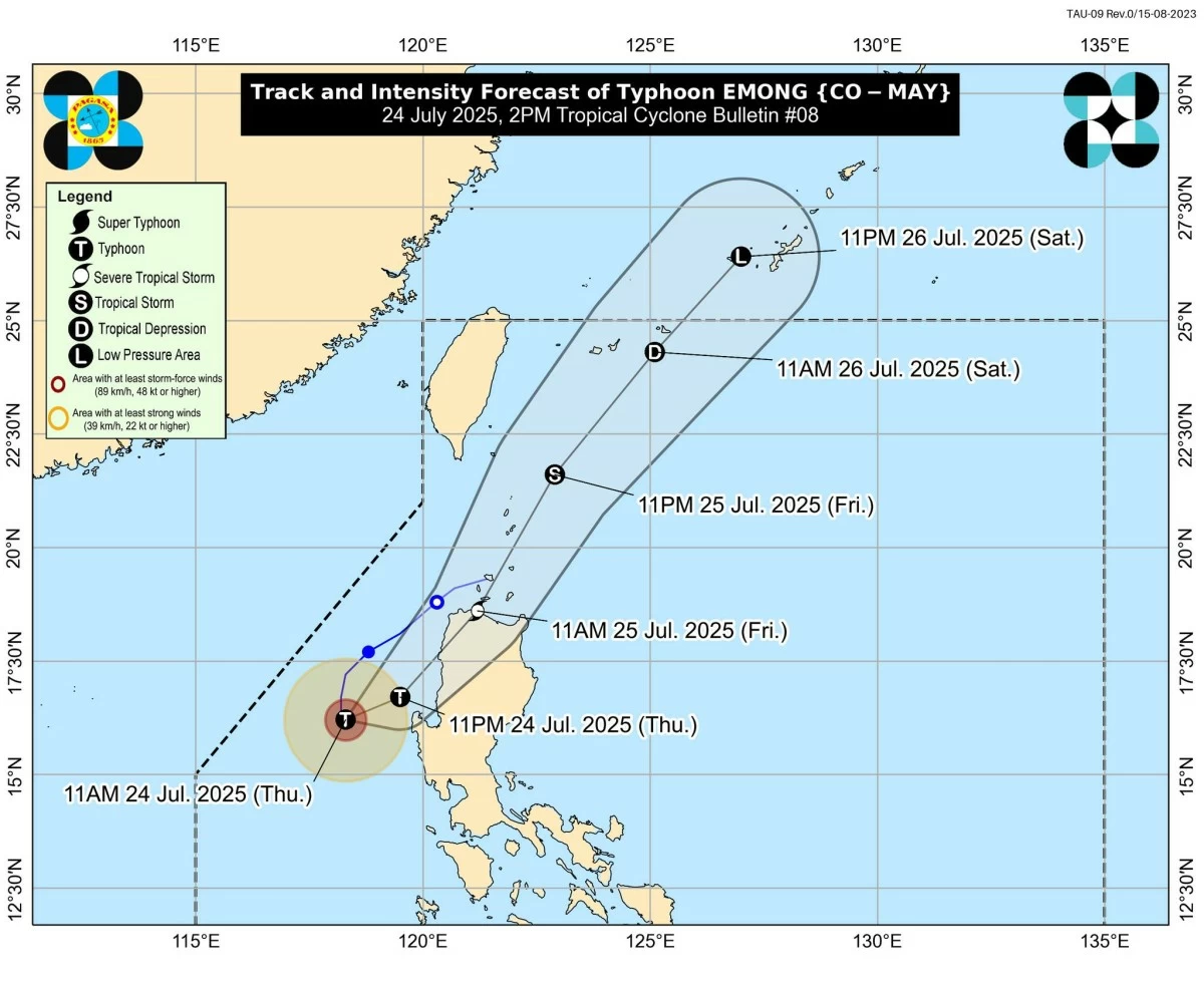
Typhoon Emong (international name: Co-may) remains a powerful weather system as it hovers almost stationary over the sea west of Pangasinan, according to the Philippine Atmospheric, Geophysical and Astronomical Services Administration (PAGASA).
In its latest Tropical Cyclone Bulletin issued at 2 p.m. on Thursday, July 24, PAGASA said the center of “Emong” was located approximately 175 kilometers west of Dagupan City, Pangasinan.
The typhoon packs maximum sustained winds of 120 km/h near the center and gusts of up to 150 km/h, with a central pressure of 975 hPa.
Strong to typhoon-force winds extend up to 150 kilometers from the eye of the storm, PAGASA said.
Landfall likely in Northern Luzon by morning of July 25
PAGASA forecasts that “Emong” will begin turning northeastward later today and may make landfall over La Union, Ilocos Sur, or Ilocos Norte by Friday morning, July 25.
A close approach or landfall over northwestern Pangasinan also remains possible, PAGASA added.
After crossing the rugged terrain of northwestern Luzon, “Emong” is expected to weaken slightly but may pass close to or hit the Babuyan Islands and Batanes between Friday noon and evening before exiting toward the Philippine Sea.
Tropical Cyclone Wind Signals raised across Luzon
Tropical Cyclone Wind Signal (TCWS) No. 3 is raised in the northern portion of Pangasinan (Anda, Bolinao, Bani), the western portion of La Union (Luna, Balaoan, Bacnotan, San Juan, City of San Fernando, Bauang, Caba, Bangar), the western portion of Ilocos Sur (San Esteban, Santiago, City of Candon, Santa Lucia, Santa Cruz, Tagudin, Santo Domingo, Cabugao, Sinait, Magsingal, San Juan, Bantay, San Vicente, San Ildefonso, Santa Catalina, City of Vigan, Caoayan, Santa, Narvacan, Santa Maria, Nagbukel, Burgos, Banayoyo), and the western portion of Abra (San Quintin, Langiden), where storm-force winds of 89–117 km/h are expected within 18 hours. Moderate to significant damage to life and property is likely in these areas.
TCWS No. 2 covers Ilocos Norte, the rest of Ilocos Sur and La Union, and the central portion of Pangasinan (Agno, Burgos, Mabini, City of Alaminos, Sual, Labrador, Bugallon, Infanta, Dasol, Lingayen, Binmaley, Dagupan City, Calasiao, Santa Barbara, Mangaldan, Mapandan, Manaoag, Laoac, Binalonan, San Manuel, San Nicolas, Pozorrubio, Sison, San Fabian, San Jacinto), the rest of Abra, Apayao, Kalinga, Mountain Province, Ifugao, Benguet, Babuyan Islands, and the northern and western portions of mainland Cagayan (Rizal, Santa Praxedes, Claveria, Sanchez-Mira, Pamplona, Abulug, Ballesteros, Aparri, Camalaniugan, Allacapan, Buguey, Santa Teresita, Santa Ana, Gonzaga, Lal-Lo, Lasam, Santo Niño, Piat, Tuao), and the western portion of Nueva Vizcaya (Kayapa, Santa Fe), which are facing gale-force winds within 24 hours.
TCWS No. 1 has been hoisted over Batanes, the rest of Cagayan, and the western and central portions of Isabela (Santo Tomas, Delfin Albano, Quezon, Mallig, Quirino, Roxas, San Manuel, Aurora, San Mateo, Ramon, Cordon, Burgos, Cabatuan, Cabagan, San Pablo, Santa Maria, Tumauini, Gamu, Luna, Maconacon, Alicia, San Mariano, Naguilian, San Guillermo, City of Cauayan, Echague, Ilagan City, Angadanan, Benito Soliven, City of Santiago, Reina Mercedes, San Agustin, Divilacan, San Isidro, Jones), the rest of Nueva Vizcaya, Quirino, the rest of Pangasinan, the northern and central portions of Zambales (Santa Cruz, Candelaria, Masinloc, Palauig, Iba, Botolan, Cabangan), Tarlac, and the western and central portions of Nueva Ecija (Carranglan, Lupao, Talugtug, Cuyapo, Nampicuan, Guimba, Science City of Muñoz, San Jose City, Pantabangan, Rizal, Llanera, Talavera, Santo Domingo, Quezon, Licab, Aliaga, Zaragoza, San Antonio, Jaen, Cabanatuan City, Santa Rosa, General Mamerto Natividad, Palayan City, Bongabon, Laur). These areas may experience strong winds within 36 hours.
Heavy rainfall, ‘habagat’ intensified
PAGASA said the southwest monsoon (habagat), further enhanced by “Emong,” is bringing heavy rain and strong winds over Metro Manila, Central and Southern Luzon, Mimaropa, Visayas, and parts of Mindanao, including Zamboanga del Norte and Northern Mindanao.
Flooding and landslides are possible, especially in mountainous and low-lying areas, PAGASA warned.
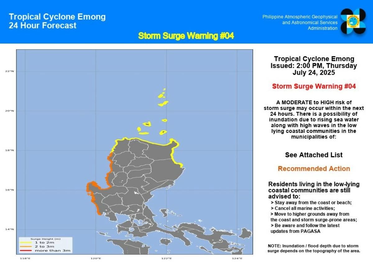
Storm surge warning: Up to 3 meters
Meanwhile, PAGASA’s Storm Surge Warning No. 4 placed several provinces at moderate to high risk of storm surges, with expected wave heights of up to 3 meters:
- 2.1 to 3.0 meters: Ilocos Sur, La Union, Pangasinan, Zambales
- 1.0 to 2.0 meters: Batanes, Cagayan, Ilocos Norte, Isabela
(PAGASA)
Residents in coastal communities are strongly advised to evacuate or stay away from shorelines and follow the guidance of local disaster risk reduction and management offices.
Maritime conditions: Travel suspended
A gale warning remains in effect for the western seaboards of Luzon, with sea conditions reaching up to 14 meters in Ilocos Sur and La Union.
Seas are deemed too dangerous for all types of marine vessels, including small motorbancas. PAGASA urged mariners to stay in port and wait for safer conditions.
Public advisory
PAGASA reminded the public and local authorities to stay updated through official bulletins and advisories; follow evacuation orders in storm surge–prone areas; and prepare for power interruptions, flooding, and possible landslides.
For localized warnings, thunderstorm advisories, and emergency instructions, the public may follow updates from their PAGASA Regional Services Division and local DRRM offices.