


Manila Bulletin
 Philippines
National
PAGASA: Tropical Storm Dante maintains strength; 'Emong' to make landfall over Northern Luzon
Philippines
National
PAGASA: Tropical Storm Dante maintains strength; 'Emong' to make landfall over Northern Luzon
Philippines
National
PAGASA: Tropical Storm Dante maintains strength; 'Emong' to make landfall over Northern Luzon
PAGASA: Tropical Storm Dante maintains strength; 'Emong' to make landfall over Northern Luzon
Published Jul 23, 2025 06:18 pm


At A Glance
- "Dante" continues to move north-northwestward and is expected to exit the Philippine Area of Responsibility by July 24, with minimal chances of further intensification
- "Emong," which formed west of the Babuyan Islands, is expected to become a tropical storm and make landfall in Ilocos Sur, La Union, or Pangasinan by early July 25, possibly reaching severe tropical storm status
- Large areas across Luzon, Visayas, and Mindanao are experiencing heavy rains, flash flood threats, and hazardous coastal conditions; gale warnings and wind signals are in effect
PAGASA / MANILA BULLETIN
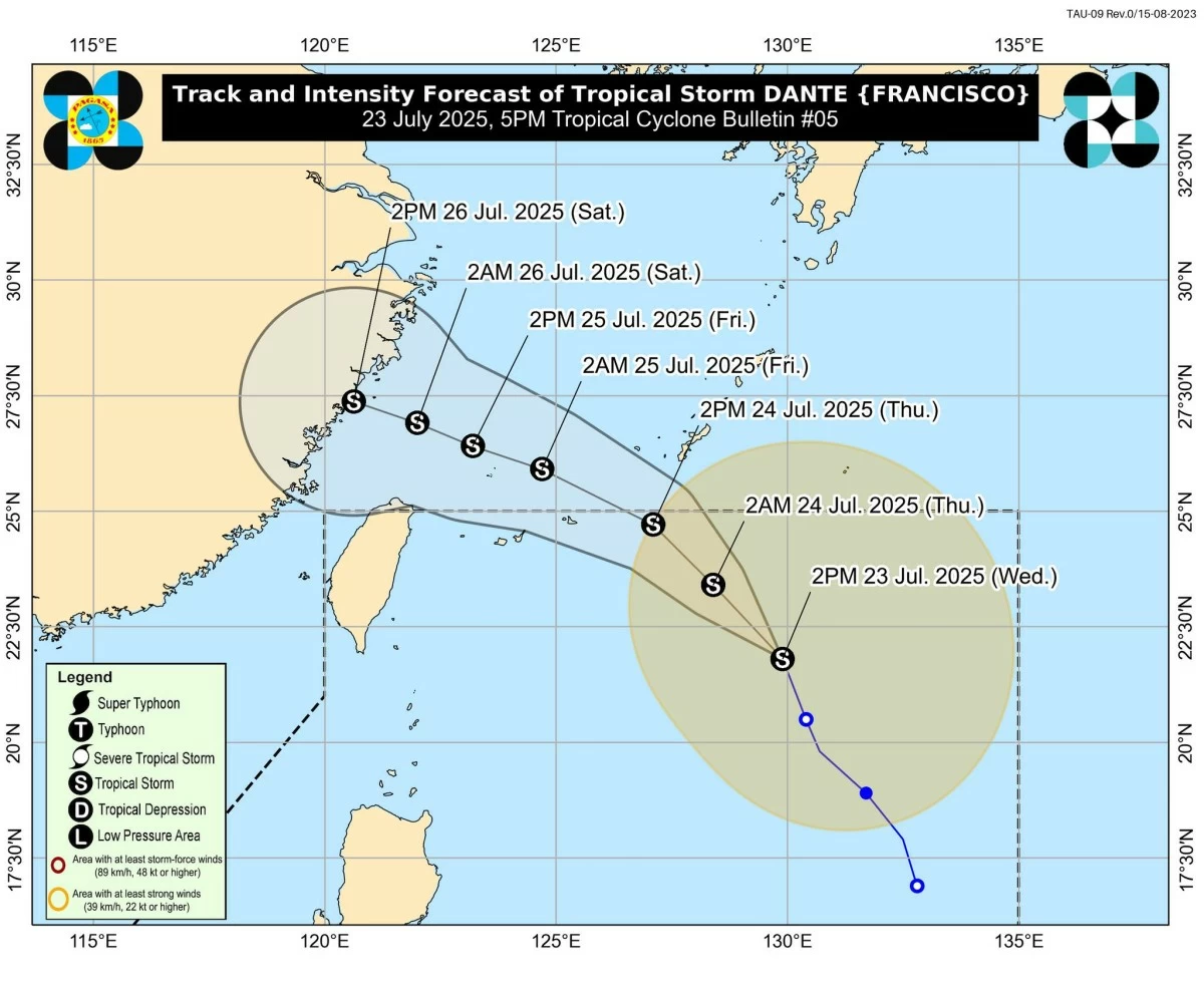
Tropical Storm Dante continues to move north-northwestward over the Philippine Sea while maintaining its strength, as the newly formed Tropical Depression Emong threatens to make landfall over Northern Luzon before the end of the week, according to the Philippine Atmospheric, Geophysical and Astronomical Services Administration (PAGASA).
As of 5 p.m. on Wednesday, July 23, PAGASA reported that “Dante” was located 835 km east-northeast of Extreme Northern Luzon, with maximum sustained winds of 65 km/h and gusts of up to 80 km/h.
PAGASA
Moving at 25 km/h, TS Dante is expected to exit the Philippine Area of Responsibility (PAR) by Thursday afternoon or evening, July 24. Although further intensification into a severe tropical storm is unlikely, PAGASA said it remains a possibility.
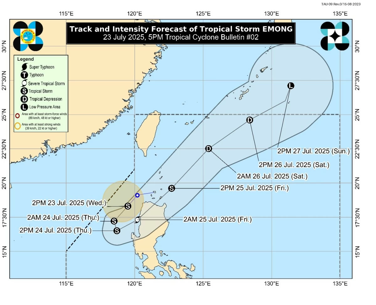
Meanwhile, TD Emong, which developed from a low-pressure area west of the Babuyan Islands, is forecast to intensify into a tropical storm before making landfall over Ilocos Sur, La Union, or Pangasinan by early Friday morning, July 25.
TD Emong is currently moving westward and may reach severe tropical storm status before weakening as it crosses the mountainous terrain of Northern Luzon.
“Emong is forecast to move generally southwestward tonight before looping over the West Philippine Sea tomorrow morning through the afternoon (July 24) due to its interaction with Tropical Storm Dante,” PAGASA said. “Afterwards, it will move generally northeastward while accelerating,” the weather bureau added.
PAGASA noted that “Emong” is likely to intensify continuously and may reach severe tropical storm category before landfall, but will weaken into a tropical storm after passing over Northern Luzon.
PAGASA
Monsoon-enhanced winds and rains affect wide areas
The southwest monsoon, enhanced by both “Dante” and “Emong,” continues to bring heavy rains and strong to gale-force winds across large parts of Luzon, the Visayas, and Mindanao.
Affected areas include Zambales, Bataan, Bulacan, Metro Manila, CALABARZON, MIMAROPA, the Bicol Region, the Visayas, and parts of Mindanao on July 23; Central Luzon, the Bicol Region, the Visayas, and provinces such as Zamboanga del Norte and Davao Oriental on July 24; and the Ilocos Region, Cordillera, Central Luzon, and the Bicol Region on July 25.
PAGASA warned that landslides and flash floods are likely, particularly in upland and low-lying areas.
Coastal waters: Gale warnings raised, sea travel discouraged
A Gale Warning remains in effect over the western seaboard of Northern Luzon, with wave heights reaching up to 6.0 meters in Pangasinan. Other areas, including Zambales, Bataan, and Lubang Island, may experience waves of 3.5 to 4.5 meters.
Mariners—particularly operators of small boats and motorbancas—are strongly advised to stay in port and avoid venturing out into rough seas along the western seaboard of Luzon, including Batanes, the Ilocos Region, Palawan, and Occidental Mindoro; the eastern seaboards of Catanduanes, Northern Samar, Albay, Sorsogon, and Davao Oriental; and the central and southern seaboards of Calabarzon and Mimaropa.
Wind signals raised over Northern Luzon due to ‘Emong’
Due to “Emong,” Tropical Cyclone Wind Signal No. 1 was raised over parts of Luzon, including Ilocos Norte, Ilocos Sur, La Union, and the northern and western portions of Pangasinan (Dasol, Burgos, Agno, Bani, Bolinao, Alaminos City, Mabini, Anda, Labrador, Sual, Binmaley, Dagupan City, Lingayen, Bugallon, Infanta, Sison, Mangaldan, San Fabian, San Jacinto, and Pozorrubio), as well as Apayao, Abra, and Benguet.
Winds of 39–61 km/h and intermittent rains are expected within 36 hours in these areas, according to PAGASA.
Stay alert, stay safe
With intensified monsoon rains triggered by two active tropical cyclones, PAGASA urged residents—especially those in northern and western Luzon—to remain vigilant and heed local government advisories.
Emergency response and disaster preparedness teams were likewise advised to stay on heightened alert in the affected provinces.