


PAGASA: Fujiwhara effect seen between 'Dante', 'Emong'
Rainy conditions to persist as twin weather systems interact
Published Jul 23, 2025 01:18 pm


PAGASA
The Philippine Atmospheric, Geophysical and Astronomical Services Administration (PAGASA) on Wednesday, July 23, said tropical cyclones “Dante” and “Emong” are beginning to interact as they draw closer to each other, a weather phenomenon known as the Fujiwhara effect.
PAGASA Administrator Dr. Nathaniel Servando said the two tropical cyclones are now only about 1,100 kilometers apart, close enough to trigger a “binary interaction.”
“Kapag ang dalawang bagyo ay may distansya na less than 1,500 kilometers, nagkakaroon ng binary interaction. Sa case ni Tropical Storm Dante and Tropical Depression Emong, halos 1,100 kilometers lang ang distansya ng dalawa. At kung titignan natin ang tracks ng dalawa, makikita natin na nagkakaroon ng interaction ‘yung dalawa,” Servando said in a briefing.
(When two tropical cyclones are less than 1,500 kilometers apart, a binary interaction occurs. In the case of Tropical Storm Dante and Tropical Depression Emong, their distance is only about 1,100 kilometers. Based on their forecast tracks, we are seeing signs of interaction between the two).
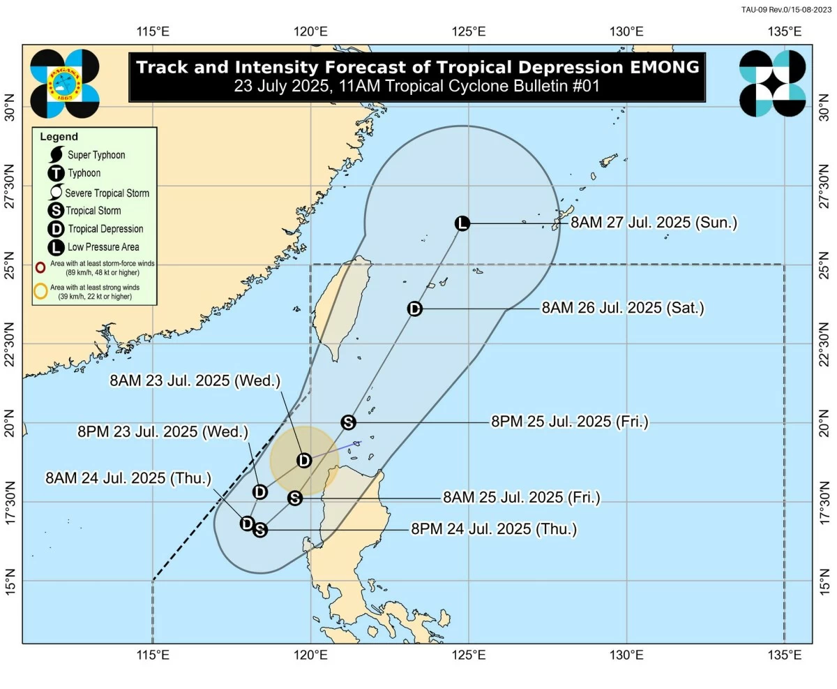
As of 11 a.m., Emong was located 115 kilometers west-northwest of Laoag City, Ilocos Norte, moving west-southwest at 35 kilometers per hour (kph), with maximum sustained winds of 45 kph and gusts of up to 55 kph.
Meanwhile, Dante (international name: Francisco) was located 900 kilometers east of extreme Northern Luzon, with sustained winds of 65 kph and gusts of up to 80 kph. It was moving north-northwest at 15 kph.
“Itong si Emong initially naglu-loop sa western side ng Ilocos Norte and eventually habang pataas, papuntang Taiwan si Dante ay hahatakin niya si Emong. Dante is stronger than Emong kaya mas dominant itong si Dante kaya instead na itong si Emong ay kikilos papuntang West Philippine Sea, ito ay sasabay kay Dante,” Servando explained.
(Emong is initially looping on the western side of Ilocos Norte. Eventually, as Dante moves north toward Taiwan, it will start pulling Emong along. Since Dante is stronger, it becomes the dominant system. So instead of Emong moving toward the West Philippine Sea, it will follow Dante’s path).
“Paglabas ni Dante sa Philippine Area of Responsibility magiging mas malapit ang kanilang distance at doon sa bandang Taiwan doon sila, not necessarily combine into one, pero ito ‘yung pinakamalapit,” he added.
(Once Dante exits the Philippine Area of Responsibility, the two systems will draw closer, particularly near Taiwan. They will not necessarily combine into one, but this will be their closest interaction).
Servando pointed out that the combined strength of the two cyclones, caused by the Fujiwhare effect, will have a greater impact on enhancing the southwest monsoon (habagat).
“Kapag nandiyan ‘yung dalawang system, we expect na ma-enhance ang mga pag-ulan dulot ng habagat,” he said.
(When both systems are present, we expect the southwest monsoon rains to be enhanced).
Likewise, because of Emong’s looping or circular movement, parts of Northern Luzon may be soaked in rain brought by the tropical depression.
Based on PAGASA’s forecast, Emong is expected to loop over the West Philippine Sea on Thursday, July 24, before accelerating northeastward.
A landfall scenario over Ilocos Region, Babuyan Islands, or Batanes remains possible, especially if there is an eastward shift in Emong’s track.
Signal No. 1 was raised over several areas in Ilocos Norte, Ilocos Sur, La Union, and western Pangasinan due to strong winds from Emong.
PAGASA warned of minimal to minor wind impacts in these areas and noted that Signal No. 2 may be hoisted if Emong intensifies further.
Meanwhile, Dante is not expected to make landfall in the Philippines but continues to enhance the habagat.
Heavy rainfall forecast
Due to the Fujiwhara effect between Dante and Emong, PAGASA expects intensified habagat rains across several areas until the weekend.
The enhanced monsoon activity, combined with the direct effects of Emong, is likely to bring moderate to torrential rainfall, especially over the northern and western sections of Luzon.
Between Wednesday noon and Thursday noon, moderate to heavy rainfall (50-100 millimeters) is expected in Cagayan, Ilocos Norte, Ilocos Sur, Abra, Kalinga, Apayao, Nueva Vizcaya, Ifugao, Mountain Province, Nueva Ecija, Quezon, Oriental Mindoro, Palawan, Marinduque, Romblon, Masbate, Sorsogon, Albay, Camarines Sur, Catanduanes, Antique, and Iloilo.
Heavy to intense rainfall (100-200 millimeters) is likely in Pangasinan, La Union, Benguet, Tarlac, Pampanga, Bulacan, Metro Manila, Cavite, Batangas, Laguna, and Rizal.
Torrential rainfall (over 200 millimeters) is expected in Zambales, Bataan, and Occidental Mindoro.
Between Thursday noon and Friday noon, July 25, moderate to heavy rainfall will affect Pangasinan, La Union, Nueva Vizcaya, Nueva Ecija, Metro Manila, Laguna, Rizal, Quezon, Oriental Mindoro, Palawan, Marinduque, and Romblon.
Heavy to intense rainfall will persist in Ilocos Norte, Ilocos Sur, Abra, Benguet, Bataan, Tarlac, Pampanga, Bulacan, Cavite, Batangas, and Occidental Mindoro.
Meanwhile, Zambales may continue to experience torrential rainfall.
Between Friday noon and Saturday noon, July 26, moderate to heavy rainfall will prevail over La Union, Kalinga, Mountain Province, Ifugao, Benguet, Bataan, Occidental Mindoro, and Palawan.
Heavy to intense rainfall will persist in Ilocos Norte, Ilocos Sur, Abra, Benguet, and Zambales.
PAGASA urged residents, especially those in flood-prone and landslide-prone areas, to monitor official updates and heed advisories from local authorities.