


Manila Bulletin
 Philippines
National
Tropical depression may develop within 24 hours, trigger more 'habagat' rains
Philippines
National
Tropical depression may develop within 24 hours, trigger more 'habagat' rains
Philippines
National
Tropical depression may develop within 24 hours, trigger more 'habagat' rains
Tropical depression may develop within 24 hours, trigger more 'habagat' rains
Published Jul 22, 2025 08:58 am


PAGASA
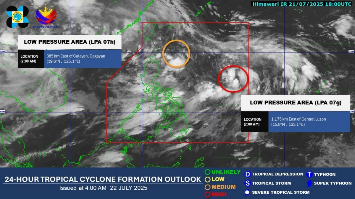
One of two low-pressure areas (LPAs) currently inside the Philippine Area of Responsibility (PAR) may develop into a tropical depression within the next 24 hours and could further enhance the southwest monsoon (habagat) in the coming days, said the Philippine Atmospheric, Geophysical and Astronomical Services Administration (PAGASA) on Tuesday, July 22.
As of 3 a.m., PAGASA weather specialist Obet Badrina said the LPA located 1,140 kilometers east of Central Luzon shows a higher chance of intensifying.
The other LPA was spotted 370 kilometers east of Calayan, Cagayan.
If one of the weather systems develops into a tropical depression while inside the PAR, it will be named “Dante.”
Although the potential cyclone is forecast to move northward with a low chance of making landfall, Badrina said its development could further enhance the southwest monsoon, increasing rainfall especially over Luzon and Visayas.
Over the next 24 hours, the trough or extension of the LPA near Cagayan will bring cloudy skies with scattered rain showers and thunderstorms to Cagayan Valley.
Monsoon rains will continue to affect Metro Manila, Cavite, Laguna, Batangas, Rizal, Quezon, Zambales, Bataan, Pampanga, Bulacan, and Occidental Mindoro.
Occasional rains are also expected in Pangasinan, Benguet, Tarlac, Marinduque, and Oriental Mindoro.
Cloudy skies with scattered rain showers and thunderstorms will prevail over Visayas, the rest of Luzon, Zamboanga Peninsula, Bangsamoro Autonomous Region in Muslim Mindanao, Soccsksargen, and Davao Region.
Meanwhile, the rest of Mindanao will experience partly cloudy to cloudy skies with isolated rain showers or thunderstorms, mostly in the afternoon or evening.
PAGASA advised residents in flood- and landslide-prone areas, particularly those that have already received significant rainfall, to remain vigilant.