


Manila Bulletin
 Philippines
National
PAGASA monitoring 3 LPAs; one may intensify into tropical depression Dante
Philippines
National
PAGASA monitoring 3 LPAs; one may intensify into tropical depression Dante
Philippines
National
PAGASA monitoring 3 LPAs; one may intensify into tropical depression Dante
PAGASA monitoring 3 LPAs; one may intensify into tropical depression Dante
Published Jul 22, 2025 12:22 pm
|
Updated Jul 22, 2025 01:13 pm


PAGASA
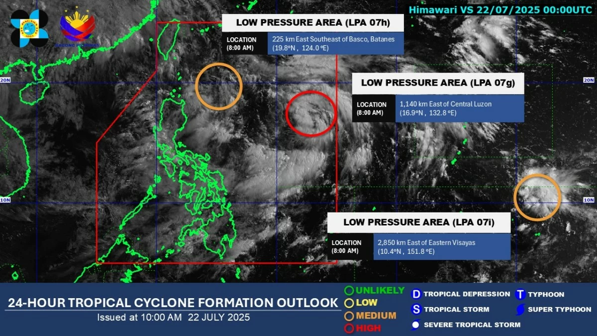
The Philippine Atmospheric, Geophysical and Astronomical Services Administration (PAGASA) is monitoring three low-pressure areas (LPAs), including one that has a high chance of developing into a tropical depression within the next 24 hours.
As of 8 a.m. on Tuesday, July 22, PAGASA reported that LPA 07g, located inside the Philippine Area of Responsibility (PAR) or 1,140 kilometers east of Central Luzon, has a “high” chance of intensifying into a tropical depression.
If it intensifies inside the PAR, PAGASA will assign it the local name “Dante.”
Another system inside PAR, LPA 07h, has a “medium” chance of development. It was last spotted 225 kilometers east-southeast of Basco, Batanes.
A third weather system, LPA 07i, currently outside PAR, also has a “medium” likelihood of becoming a tropical depression within 24 hours.
It was located 2,850 kilometers east of Eastern Visayas.
In a public briefing at 5 a.m., PAGASA weather specialist Obet Badrina said the potential cyclone is expected to move northward with a low chance of making landfall in the country.
However, its development could enhance the southwest monsoon, or “habagat,” which may bring more rain, particularly over Luzon and Visayas.
PAGASA has issued a heavy rainfall forecast until Friday, July 25.
From Tuesday until Wednesday noon, July 23, torrential rains (more than 200 millimeters) are expected in Zambales, Bataan, Metro Manila, Cavite, Batangas, and Occidental Mindoro.
Intense to torrential rainfall (100 to 200 millimeters) is likely in Pangasinan, Benguet, Tarlac, Pampanga, Bulacan, Laguna, and Rizal.
Meanwhile, heavy to intense rainfall (50 to 100 millimeters) is expected in Ilocos Norte, Ilocos Sur, La Union, Abra, Nueva Ecija, Quezon, Oriental Mindoro, Palawan, Marinduque, Romblon, Masbate, Sorsogon, Albay, Camarines Sur, Catanduanes, Antique, Iloilo, Guimaras, and Negros Occidental.
From Wednesday noon to Thursday noon, July 24, torrential rainfall will persist in Pangasinan, Zambales, and Bataan.
La Union, Benguet, Pampanga, Bulacan, Metro Manila, Cavite, Batangas, Laguna, Rizal, and Occidental Mindoro may receive intense to torrential rainfall, while Ilocos Norte, Ilocos Sur, Abra, Ifugao, Mountain Province, Nueva Vizcaya, Tarlac, Nueva Ecija, Quezon, Oriental Mindoro, Palawan, Marinduque, Romblon, Albay, Camarines Sur, Catanduanes, and Antique may experience heavy to intense rains.
From Thursday noon to Friday noon, intense to torrential rainfall is expected in Ilocos Norte, Ilocos Sur, La Union, Pangasinan, Zambales, and Bataan.
Meanwhile, Apayao, Abra, Benguet, Tarlac, Pampanga, Bulacan, Metro Manila, Cavite, Batangas, Rizal, Laguna, Quezon, Occidental Mindoro, Oriental Mindoro, Marinduque, Romblon, Palawan, and Antique may receive heavy to intense rains.
PAGASA advised residents, particularly in low-lying and mountainous areas, to remain alert for possible flash floods and landslides and to continue monitoring its weather updates.