


Manila Bulletin
 Philippines
National
LPA east of Luzon develops into Tropical Depression Dante — PAGASA
Philippines
National
LPA east of Luzon develops into Tropical Depression Dante — PAGASA
Philippines
National
LPA east of Luzon develops into Tropical Depression Dante — PAGASA
LPA east of Luzon develops into Tropical Depression Dante — PAGASA
Published Jul 22, 2025 06:20 pm


PAGASA
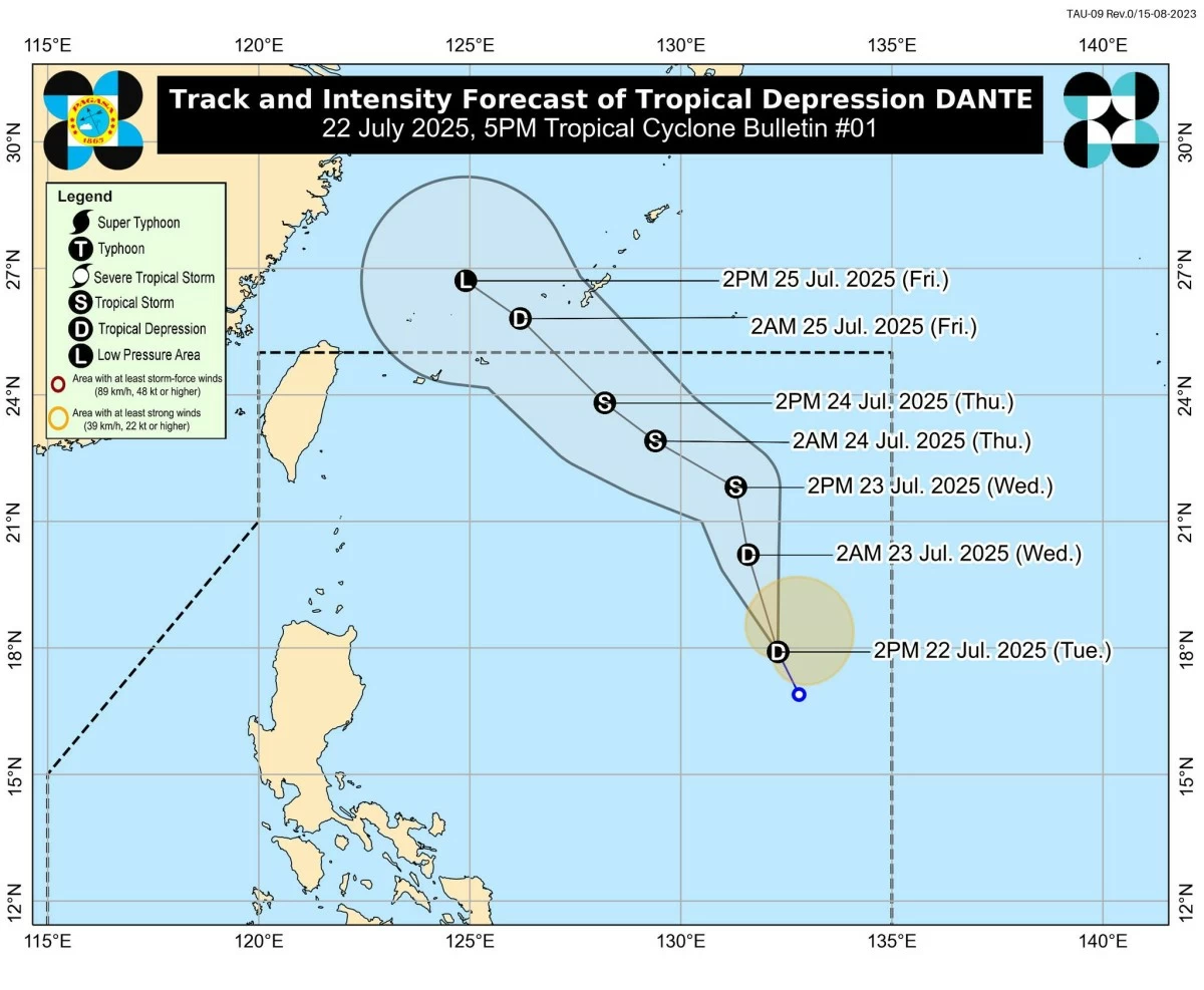
The Philippine Atmospheric, Geophysical and Astronomical Services Administration (PAGASA) said the low-pressure area (LPA) east of Aurora has developed into a tropical depression on Tuesday afternoon, July 22, and was named “Dante”
As of 4 p.m., the center of Dante was located 1,115 kilometers east-northeast of Central Luzon or 1,130 kilometers east of Northern Luzon and was moving north-northwestward at 20 kilometers per hour (kph).
It has maximum sustained winds of 45 kph, with gusts reaching up to 55 kph.
PAGASA said Dante may intensify into a tropical storm by Thursday, July 24.
As of Tuesday’s forecast, PAGASA said that although further intensification into a severe tropical storm is unlikely, it cannot be ruled out.
Dante is expected to continue moving northward or north-northwestward over the Philippine Sea from Wednesday evening, July 23, into Thursday, July 24, before turning northwest toward the Ryukyu Islands and the East China Sea.
The tropical depression may exit the Philippine Area of Responsibility (PAR) between Thursday and Friday.
In a press briefing on Tuesday afternoon, PAGASA Assistant Weather Services chief Chris Perez said the chance of Dante making landfall or directly affecting any part of the country remains low.
However, Perez explained that when cyclones move over the Pacific Ocean without making landfall, either passing near northern Luzon, heading toward Taiwan, or along the northern boundary of the PAR, this often enhances the southwest monsoon (habagat), which brings increased rainfall to the Philippines.
Aside from Dante, PAGASA is also closely monitoring another LPA located 155 kilometers east-southeast of Basco, Batanes.
While the system has a low chance of developing into a tropical cyclone within the next 24 hours, Perez said it may still intensify beyond that period.
He explained that the LPA may follow one of two possible scenarios—either it will cross extreme Northern Luzon and exit through the western boundary of the PAR, where it could eventually strengthen into a tropical cyclone over the West Philippine Sea, or it may be absorbed by the stronger tropical depression Dante.
Meanwhile, PAGASA is also monitoring another LPA located outside the PAR, about 2,705 kilometers east of Eastern Visayas.
Perez said this weather system is not expected to have any direct impact on the country or influence the weather systems currently within the PAR.