ADVERTISEMENT

PAGASA: 'Crising' now a Severe Tropical Storm, exits PAR

'Habagat', coastal hazards expected to persist

Published Jul 19, 2025 11:43 am  |  Updated Jul 19, 2025 01:16 pm
PAGASA
PAGASA
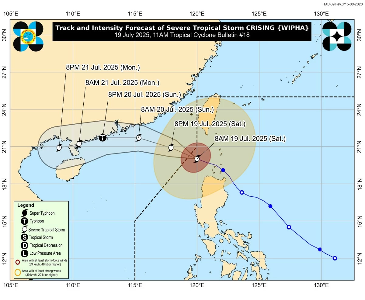
Severe Tropical Storm Crising (international name: Wipha) officially exited the Philippine Area of Responsibility (PAR) on Saturday, July 19 but it will continue to enhance the Southwest Monsoon (habagat), which will bring heavy rains, strong winds, and hazardous sea conditions across much of the country in the coming days, according to the Philippine Atmospheric, Geophysical and Astronomical Services Administration (PAGASA).
In its 11 a.m. bulletin, PAGASA said “Crising” intensified into a severe tropical storm (STS) and has exited PAR. However, the weather bureau warned that the system continues to enhance the “habagat,” which will bring rains and winds to many areas across the country.
As of 10 a.m., the center of Crising was located approximately 235 km west of Itbayat, Batanes, moving westward at 15 km/h, with maximum sustained winds of 100 km/h and gusts of up to 125 km/h.
The storm is expected to intensify further and may reach typhoon category by Sunday, July 20, as it heads toward southern China, PAGASA added.
Monsoon rains, gusty winds to persist
Although Crising is no longer within the country’s jurisdiction, PAGASA said its interaction with the Southwest Monsoon will continue to affect large portions of Luzon, Visayas, and Mindanao.
Strong to gale-force winds are expected today in Metro Manila, Central Luzon, Calabarzon, the Bicol Region, MIMAROPA, the Visayas, and parts of Northern Mindanao, including Zamboanga del Norte, Camiguin, and Misamis provinces.
This wind pattern is forecast to persist through Monday, July 21, with the worst impacts likely in exposed coastal and mountainous areas.
Tropical Cyclone Wind Signals still in effect
As of this advisory, Tropical Cyclone Wind Signal (TCWS) No. 2 remains hoisted over parts of Luzon, including Batanes, the western portion of the Babuyan Islands (Dalupiri Island and Calayan Island), and Ilocos Norte (Burgos, Pasuquin, Pagudpud, Dumalneg, and Bangui).
Meanwhile, TCWS No. 1 is raised over the rest of Ilocos Norte, Ilocos Sur, the northern portion of La Union (Bangar, Sudipen, Luna, Balaoan, Santol, San Gabriel, Bacnotan, and San Juan), as well as Abra, Apayao, Kalinga, and the rest of Cagayan.
PAGASA said these areas may experience gale-force to strong winds that could cause minor to moderate damage to light structures and potential disruptions to power lines and trees.
Storm surge, dangerous seas continue
PAGASA earlier issued a storm surge warning, with wave heights possibly reaching 1.0 to 2.0 meters in low-lying coastal areas of Batanes, Cagayan (including the Babuyan Islands), Ilocos Norte, and Ilocos Sur. Coastal residents are advised to remain alert and follow evacuation orders if necessary.
A Gale Warning is also in effect for the northern and western seaboards of Northern Luzon, where sea conditions may reach up to 4.5 meters.
Sea travel is considered risky for all types of vessels, especially small boats and motorbancas, PAGASA warned.
Mariners are strongly advised to remain in port or seek safe harbor until conditions improve, the agency added.
READ: 
https://mb.com.ph/2025/07/19/pagasa-issues-storm-surge-warning-in-northern-luzon-as-crising-intensifies
‘Crising’ may become a typhoon
PAGASA forecasts indicate that “Crising” will continue to intensify as it moves west-northwest toward southern China.
“Crising is forecast to continue intensifying and may reach typhoon category tomorrow (20 July) afternoon or evening,” PAGASA stated.
Precautionary measures
Although “Crising” is now outside PAR, its indirect effects—such as flooding, landslides, and travel disruptions—may still occur due to the enhanced “habagat,” according to PAGASA.
Disaster management agencies are urged to remain on high alert, while local government units are advised to continue preparations and respond promptly to weather-related emergencies.

Related Tags

Severe Tropical Storm Crising Crising exits PAR Crising update July 19 2025 Crising storm surge warning PAGASA Crising advisory Crising forecast track Southwest Monsoon rains CrisingPH
ADVERTISEMENT
.most-popular .layout-ratio{ padding-bottom: 79.13%; } @media (min-width: 768px) and (max-width: 1024px) { .widget-title { font-size: 15px !important; } }

{{ articles_filter_1561_widget.title }}

.most-popular .layout-ratio{ padding-bottom: 79.13%; } @media (min-width: 768px) and (max-width: 1024px) { .widget-title { font-size: 15px !important; } }

{{ articles_filter_1562_widget.title }}

.most-popular .layout-ratio{ padding-bottom: 79.13%; } @media (min-width: 768px) and (max-width: 1024px) { .widget-title { font-size: 15px !important; } }

{{ articles_filter_1563_widget.title }}

{{ articles_filter_1564_widget.title }}

.mb-article-details { position: relative; } .mb-article-details .article-body-preview, .mb-article-details .article-body-summary{ font-size: 17px; line-height: 30px; font-family: "Libre Caslon Text", serif; color: #000; } .mb-article-details .article-body-preview iframe , .mb-article-details .article-body-summary iframe{ width: 100%; margin: auto; } .read-more-background { background: linear-gradient(180deg, color(display-p3 1.000 1.000 1.000 / 0) 13.75%, color(display-p3 1.000 1.000 1.000 / 0.8) 30.79%, color(display-p3 1.000 1.000 1.000) 72.5%); position: absolute; height: 200px; width: 100%; bottom: 0; display: flex; justify-content: center; align-items: center; padding: 0; } .read-more-background a{ color: #000; } .read-more-btn { padding: 17px 45px; font-family: Inter; font-weight: 700; font-size: 18px; line-height: 16px; text-align: center; vertical-align: middle; border: 1px solid black; background-color: white; } .hidden { display: none; }
function initializeAllSwipers() { // Get all hidden inputs with cms_article_id document.querySelectorAll('[id^="cms_article_id_"]').forEach(function (input) { const cmsArticleId = input.value; const articleSelector = '#article-' + cmsArticleId + ' .body_images'; const swiperElement = document.querySelector(articleSelector); if (swiperElement && !swiperElement.classList.contains('swiper-initialized')) { new Swiper(articleSelector, { loop: true, pagination: false, navigation: { nextEl: '#article-' + cmsArticleId + ' .swiper-button-next', prevEl: '#article-' + cmsArticleId + ' .swiper-button-prev', }, }); } }); } setTimeout(initializeAllSwipers, 3000); const intersectionObserver = new IntersectionObserver( (entries) => { entries.forEach((entry) => { if (entry.isIntersecting) { const newUrl = entry.target.getAttribute("data-url"); if (newUrl) { history.pushState(null, null, newUrl); let article = entry.target; // Extract metadata const author = article.querySelector('.author-section').textContent.replace('By', '').trim(); const section = article.querySelector('.section-info ').textContent.replace(' ', ' '); const title = article.querySelector('.article-title h1').textContent; // Parse URL for Chartbeat path format const parsedUrl = new URL(newUrl, window.location.origin); const cleanUrl = parsedUrl.host + parsedUrl.pathname; // Update Chartbeat configuration if (typeof window._sf_async_config !== 'undefined') { window._sf_async_config.path = cleanUrl; window._sf_async_config.sections = section; window._sf_async_config.authors = author; } // Track virtual page view with Chartbeat if (typeof pSUPERFLY !== 'undefined' && typeof pSUPERFLY.virtualPage === 'function') { try { pSUPERFLY.virtualPage({ path: cleanUrl, title: title, sections: section, authors: author }); } catch (error) { console.error('ping error', error); } } // Optional: Update document title if (title && title !== document.title) { document.title = title; } } } }); }, { threshold: 0.1 } ); function showArticleBody(button) { const article = button.closest("article"); const summary = article.querySelector(".article-body-summary"); const body = article.querySelector(".article-body-preview"); const readMoreSection = article.querySelector(".read-more-background"); // Hide summary and read-more section summary.style.display = "none"; readMoreSection.style.display = "none"; // Show the full article body body.classList.remove("hidden"); } document.addEventListener("DOMContentLoaded", () => { let loadCount = 0; // Track how many times articles are loaded const offset = [1, 2, 3, 4, 5, 6, 7, 8, 9, 10]; // Offset values const currentUrl = window.location.pathname.substring(1); let isLoading = false; // Prevent multiple calls if (!currentUrl) { console.log("Current URL is invalid."); return; } const sentinel = document.getElementById("load-more-sentinel"); if (!sentinel) { console.log("Sentinel element not found."); return; } function isSentinelVisible() { const rect = sentinel.getBoundingClientRect(); return ( rect.top < window.innerHeight && rect.bottom >= 0 ); } function onScroll() { if (isLoading) return; if (isSentinelVisible()) { if (loadCount >= offset.length) { console.log("Maximum load attempts reached."); window.removeEventListener("scroll", onScroll); return; } isLoading = true; const currentOffset = offset[loadCount]; window.loadMoreItems().then(() => { let article = document.querySelector('#widget_1690 > div:nth-last-of-type(2) article'); intersectionObserver.observe(article) loadCount++; }).catch(error => { console.error("Error loading more items:", error); }).finally(() => { isLoading = false; }); } } window.addEventListener("scroll", onScroll); });

Sign up by email to receive news.