


Manila Bulletin
 Philippines
National
PAGASA monitors possible new weather disturbance after 'Crising'
Philippines
National
PAGASA monitors possible new weather disturbance after 'Crising'
Philippines
National
PAGASA monitors possible new weather disturbance after 'Crising'
PAGASA monitors possible new weather disturbance after 'Crising'
Published Jul 18, 2025 10:00 pm


PAGASA
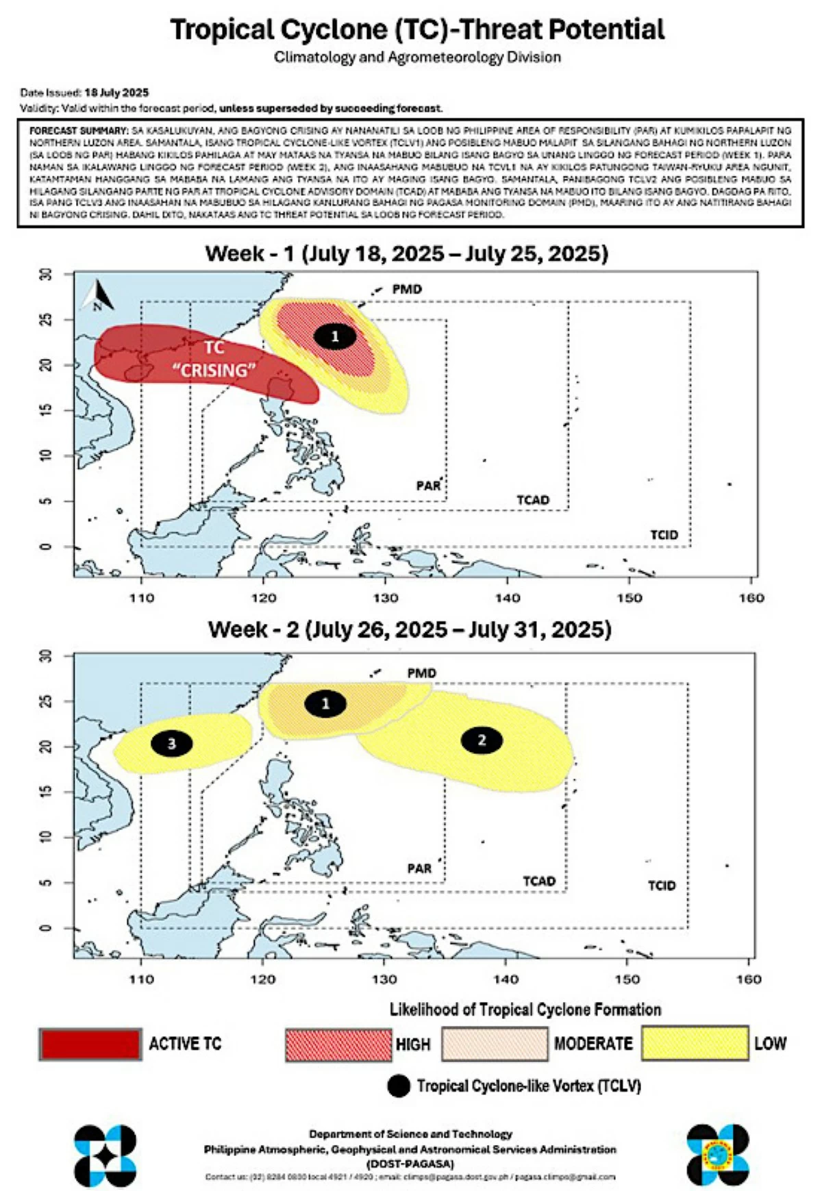
While tropical storm “Crising” (international name “Wipha”) continues to traverse Northern Luzon, the Philippine Atmospheric, Geophysical and Astronomical Services Administration (PAGASA) is monitoring the possible formation of another weather disturbance early next week.
As of Friday evening, July 18, Crising remains inside the Philippine Area of Responsibility (PAR) and is moving closer to the Babuyan Islands.
Based on PAGASA’s two-week tropical cyclone threat potential forecast, a tropical cyclone-like vortex (TCLV1) may form near the eastern part of Northern Luzon within the PAR.
It is expected to move northward and has a high likelihood of developing into a tropical cyclone during the first week of the forecast period, from July 18 to 25.
This system will be named “Dante” once it becomes a tropical depression inside the PAR.
In the second week of the forecast period, from July 26 to 31, TCLV1 is projected to move toward the Taiwan-Ryukyu area, although its probability of intensifying into a tropical cyclone will decrease to moderate or low.
At the same time, a new tropical cyclone-like vortex (TCLV2) may develop in the northeastern part of the PAR, but the likelihood of it becoming a tropical cyclone remains low.
Another possible vortex (TCLV3) could develop in the northwestern part of the PAGASA’s monitoring domain, which could be the remnants of Crising.
Weather outlook
Until Saturday, July 19, PAGASA said tropical storm Crising will continue to bring stormy weather across Cagayan Valley, Cordillera Administrative Region, and Ilocos Region.
Nueva Ecija and Aurora, as well as the rest of Northern Luzon, may experience rainy conditions and gusty winds.
Occasional rains are expected in the western parts of Central and Southern Luzon and Visayas.
Elsewhere, skies will be cloudy, with scattered rains and possible thunderstorms.
Between Sunday, July 20, and Thursday, July 24, PAGASA said Crising will have already exited the PAR.
However, the southwest monsoon (habagat) will continue to bring occasional rains over the western sections of Luzon and Visayas.
The rest of Luzon and Visayas can expect cloudy skies with scattered rains and thunderstorms.
Mindanao will have generally fair weather, but isolated rains or thunderstorms may still occur.
On Friday, July 25, PAGASA said the combined effects of a possible Low-Pressure Area (LPA) and the habagat will cause occasional rains in the western part of Luzon.
Cloudy skies with scattered rains and thunderstorms will also affect Negros Island Region, Western Visayas, and the rest of Luzon.
The rest of the country will have generally fair weather, with isolated rain showers or thunderstorms.