


Manila Bulletin
 Philippines
National
'Crising' may reach Severe Tropical Storm category before exiting PAR by July 19
Philippines
National
'Crising' may reach Severe Tropical Storm category before exiting PAR by July 19
Philippines
National
'Crising' may reach Severe Tropical Storm category before exiting PAR by July 19
'Crising' may reach Severe Tropical Storm category before exiting PAR by July 19
PAGASA said TS Crising continues to intensify as it heads toward mainland Cagayan, Babuyan Islands
Published Jul 18, 2025 12:13 pm
|
Updated Jul 18, 2025 01:07 pm


At A Glance
- Tropical Storm Crising intensifies as it heads toward Cagayan and Babuyan Islands
- PAGASA issues Signal No. 2 warnings with possible landfall this afternoon
- Storm surge, heavy rain, and rough seas expected
PAGASA
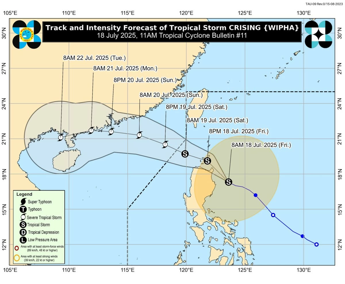
The Philippine Atmospheric, Geophysical and Astronomical Services Administration (PAGASA) on Friday, July 18, said that Tropical Storm Crising (international name: “Wipha”), which slightly intensified as it moved west-northwestward toward mainland Cagayan and the Babuyan Islands, may reach the Severe Tropical Storm category before exiting the Philippine Area of Responsibility (PAR).
In its 11 a.m. bulletin, PAGASA said “Crising” will move generally northwestward within the next 12 hours.
“On the forecast track, a landfall scenario over mainland Cagayan or the Babuyan Islands this afternoon or evening is possible,” PAGASA said. “Crising will continue to intensify until it reaches Severe Tropical Storm category by tomorrow morning or afternoon,” it added.
PAGASA said “Crising” is expected to move west-northwestward, traversing Extreme Northern Luzon until it exits PAR by the afternoon of Saturday, July 19.
‘Crising’ intensifies
PAGASA said the center of “Crising” was located 195 kilometers east of Tuguegarao City, Cagayan, as of 10 a.m., carrying maximum sustained winds of 75 km/h near the center and gusts of up to 90 km/h.
The storm is moving west-northwestward at 25 km/h and is expected to make landfall over mainland Cagayan or the Babuyan Islands later this afternoon or evening.
Tropical Cyclone Wind Signals in effect
As it moves west-northwestward, PAGASA said “Crising” is expected to bring heavy rains and strong winds over mainland Cagayan and the Babuyan Islands.
This prompted the weather bureau to raise Tropical Cyclone Wind Signals (TCWS) over several parts of Northern and Central Luzon.
Areas under Signal No. 2, which may experience winds of 62 to 88 km/h within 24 hours, include Batanes, Cagayan including the Babuyan Islands, Isabela, Apayao, Kalinga, the northern and central portions of Abra (Manabo, Pidigan, San Juan, Tayum, Langiden, Boliney, Sallapadan, Bucloc, Lagangilang, Danglas, La Paz, Licuan-Baay, Tineg, Malibcong, Peñarrubia, San Isidro, Daguioman, San Quintin, Dolores, Lagayan, Bangued, Bucay, Lacub), the eastern portion of Mountain Province (Natonin, Paracelis), the eastern portion of Ifugao (Aguinaldo, Alfonso Lista), Ilocos Norte, and the northern portion of Ilocos Sur (Cabugao, Sinait, Magsingal, San Juan, San Ildefonso, Santo Domingo, Bantay, San Vicente, Santa Catalina, Caoayan, City of Vigan, Santa).
PAGASA noted that Signal No. 1 was also raised in Quirino, Nueva Vizcaya, the rest of Mountain Province, the rest of Ifugao, the rest of Abra, Benguet, the rest of Ilocos Sur, La Union, the northern portion of Pangasinan (San Nicolas, Natividad, San Quintin, San Manuel, Tayug, Sison, San Fabian, Pozorrubio, Laoac, Binalonan, San Jacinto, Manaoag, Mangaldan, Dagupan City, Binmaley, Lingayen, Labrador, Sual, City of Alaminos, Bolinao, Anda, Bani, Agno, Burgos, Mabini, Dasol, Calasiao, Santa Barbara, Mapandan, Bugallon), the northern portion of Aurora (Dilasag, Casiguran, Dinalungan, Dipaculao, Baler, Maria Aurora), and the northeastern portion of Nueva Ecija (Carranglan, Pantabangan).
Rainfall, wind hazards
PAGASA advised the public to refer to its rainfall forecasts, as heavy rains combined with strong winds may lead to flooding, landslides, and structural damage in many areas.
In addition to storm-related winds, PAGASA said the southwest monsoon (habagat) is expected to enhance gusty conditions over large areas of Luzon, Visayas, and parts of Mindanao through Sunday, July 20, including Metro Manila, Central Luzon, Calabarzon, and Mimaropa.
Storm surge, coastal warnings
Meanwhile, PAGASA warned of a storm surge up to 2.0 meters over low-lying and coastal areas of Batanes, Cagayan including the Babuyan Islands, Isabela, Ilocos Norte, and Ilocos Sur within the next 24 hours.
PAGASA urged the public to remain vigilant and heed warnings from local government units.
Moreover, PAGASA said a Gale Warning is in effect for the northern seaboard of Northern Luzon.
PAGASA said sea travel remains risky due to wave heights reaching up to 6.0 meters (Batanes and Babuyan Islands); up to 4.5 meters (Ilocos Norte and Cagayan seaboards); up to 3.5 meters (parts of Palawan, Antique, and Western Visayas); and up to 2.5 meters (Aurora, Catanduanes, Romblon, Bohol, and Davao Oriental coastal waters).
Mariners of small sea vessels, PAGASA said, are strongly advised against sailing under these conditions, especially if inexperienced or operating ill-equipped motorbancas.
PAGASA also advised residents, especially in high-risk areas, to take precautionary measures and follow evacuation orders from local disaster risk reduction offices.