


Manila Bulletin
 Philippines
National
Habagat rains shift to Visayas, Mindanao; 3 low-pressure areas monitored — PAGASA
Philippines
National
Habagat rains shift to Visayas, Mindanao; 3 low-pressure areas monitored — PAGASA
Philippines
National
Habagat rains shift to Visayas, Mindanao; 3 low-pressure areas monitored — PAGASA
Habagat rains shift to Visayas, Mindanao; 3 low-pressure areas monitored — PAGASA
By Jel Santos
Published Jul 10, 2025 08:02 pm


(PHOTO: DOST-PAGASA)
The southwest monsoon or habagat will continue to bring rain over large parts of the country, with heavier rainfall now shifting toward the Visayas and Mindanao, the Philippine Atmospheric, Geophysical and Astronomical Services Administration (PAGASA) said Thursday, July 10.
“Patuloy pa rin po ang epekto ng southwest monsoon or hanging habagat sa malaking bahagi ng ating bansa (The southwest monsoon continues to affect a large portion of our country),” PAGASA weather specialist Benison Estareja said.
He noted that monsoon rains are now concentrating more in the south.
“Subalit kung mapapansin natin ‘yung ating latest satellite animation, nagshi-shift ‘yung malalakas na ulan from areas sa western section ng Luzon, pababa rito sa may Visayas and Mindanao (However, as we can see in the latest satellite animation, heavy rains are shifting from the western section of Luzon down to the Visayas and Mindanao),” the weather specialist said.
The state weather bureau said from Thursday afternoon until early Friday morning, there is a high chance of rain in many areas including Visayas, Mindanao, almost the entire MIMAROPA, Zambales, Bataan, Cavite, Batangas, Metro Manila, and up to the Batanes and Babuyan Islands.
“Simula po ngayong hapon hanggang bukas ng madaling araw, mataas po tyansa ng ulan dito sa may Visayas, Mindanao, halos buong MIMAROPA, at maging dito rin po sa mga probinsya ng Zambales, Bataan, Cavite, Batangas, Metro Manila, paakyat ng Batanes and Babuyan Group of Islands (From this afternoon until tomorrow early morning, there is a high chance of rain in the Visayas, Mindanao, almost all of MIMAROPA, as well as in the provinces of Zambales, Bataan, Cavite, Batangas, Metro Manila, up to Batanes and the Babuyan Group of Islands),” Estareja reported.
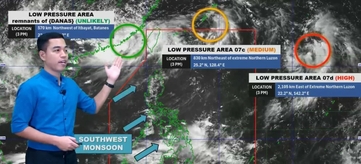
Meanwhile, the weather specialist said that three low-pressure areas (LPAs) are currently being monitored, although none of them have a direct impact on the country as of now.
“Samantala, base rin sa ating latest satellite animation, mayroon po tayong namamataan na hindi lang isa kundi tatlong low-pressure area sa paligid ng Philippine Area of Responsibility (Meanwhile, based on our latest satellite animation, we are monitoring not just one but three low-pressure areas near the Philippine Area of Responsibility),” he said.
One of them, he said, is the former tropical cyclone Danas, now downgraded to an LPA.
Estareja said it is looping just outside the country’s area of responsibility and is not expected to re-intensify.
“Nandito palapit sa ating Philippine Area of Responsibility, kung mapapansin po nila nagkaroon ng pag-ikot o looping direction po ‘yung movement nitong low-pressure area pero wala na siyang direct effect sa ating bansa (It is near the Philippine Area of Responsibility, and you may notice a looping movement, but it no longer has any direct effect on our country),” he said.
He said the second LPA exited PAR at 1 p.m. Thursday and was last spotted 830 kilometers northeast of extreme Northern Luzon, adding that it has a moderate chance of developing into a tropical depression.
PAGASA said the third LPA, located more than 2,100 kilometers east of Batanes, has a high chance of becoming a tropical depression within 24 hours. However, it is not expected to enter PAR.
“Kung saka-sakaling maging isang bagyo ay hindi naman papasok ng Philippine Area of Responsibility (If it does become a storm, it is not expected to enter the Philippine Area of Responsibility),” Estareja noted.
“Itong tatlong low-pressure areas ay walang direktang epekto sa ating bansa (These three low-pressure areas have no direct effect on our country).”