ADVERTISEMENT

Tropical depression Bising slightly intensifies, may become a storm — PAGASA

Published Jul 4, 2025 12:29 pm  |  Updated Jul 4, 2025 06:17 pm
PAGASA
PAGASA
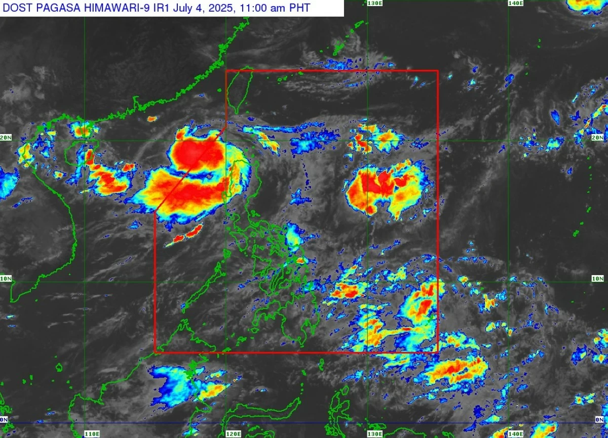
Tropical depression “Bising” has slightly intensified as it moves slowly northwestward over the sea west of extreme Northern Luzon on Friday, July 4, based on the latest bulletin from the Philippine Atmospheric, Geophysical and Astronomical Services Administration (PAGASA).
As of 11 a.m. on Friday, the center of Bising was located 220 kilometers northwest of Laoag City, Ilocos Norte. 
It is moving west-southwestward at 15 kilometers per hour (kph), with maximum sustained winds of 55 kph and gusts reaching up to 70 kph.
PAGASA said Bising will continue its slow movement and is likely to exit the Philippine Area of Responsibility (PAR) by Friday afternoon. 
However, a possible reentry by early Sunday, July 6, remains, depending on the cyclone’s interaction with surrounding weather systems. 
Forecast models also suggest that Bising could intensify into a tropical storm by Saturday as it traverses the open sea south of Taiwan.
Although Bising remains offshore, its outer circulation combined with the enhanced southwest monsoon (habagat) is affecting parts of northern and western Luzon. 
These conditions are bringing strong winds, intermittent rainfall, and rough coastal waters, particularly in areas exposed to prevailing winds. 
Wind warnings
Tropical Cyclone Wind Signal No. 1 is currently in effect over the western parts of Babuyan Islands (Calayan Island and Dalupiri Island), western portions of Ilocos Norte (Pagudpud, Bangui, Burgos, Pasuquin, Dumalneg, Bacarra, Laoag City, Paoay, Currimao, Badoc, Pinili), and northwestern parts of Ilocos Sur (Caoayan, City of Vigan, Santa Catalina, San Vicente, Santo Domingo, Magsingal, San Juan, Cabugao, Sinait, San Ildefonso).
Under Signal No. 1, minimal to minor impacts such as downed branches, light structural damage, and isolated power outages may occur.
PAGASA also warned that a southward shift in Bising’s track is possible, which could lead to the escalation of wind warnings to Signal No. 2 in areas including Batanes and Babuyan Islands.
Heavy rainfall
From Friday until Saturday noon, rainfall associated with Bising may reach 100–200 mm (heavy to intense) in Ilocos Norte, while 50–100 mm (moderate to heavy) in Batanes, Cagayan, and Apayao.
Between Saturday noon and Sunday noon, moderate to heavy rainfall (50–100 mm) is expected over Batanes, Cagayan, Apayao, and Ilocos Norte. 
From Sunday noon to Monday noon, July 7, moderate to heavy rainfall will likely persist in Batanes.
Meanwhile, the habagat will bring 50–100 mm of rain from Friday until Saturday noon across Ilocos Sur, La Union, Pangasinan, Abra, Benguet, Zambales, and Bataan. 
Between Saturday noon and Sunday noon, Ilocos Sur, La Union, and Pangasinan will continue to experience moderate to heavy rainfall.
From Sunday noon to Monday noon, Ilocos Norte will be affected by moderate to heavy monsoon rains.
PAGASA Assistant Weather Services Chief Chris Perez said rain has already been affecting the northern and western sections of Central Luzon and continues to fall over areas that have been saturated in the last few days.
He warned that additional rainfall could further soften the ground, increasing the risk of landslides and flooding, especially in low-lying and vulnerable communities.
Perez also noted that although Bising remains far from land, PAGASA continues to closely monitor the system due to the ongoing threat of flooding and landslides.
Rough seas
Sea travel is also risky as rough to moderate sea conditions are expected to persist over the next 24 hours. 
Wave heights could reach up to 3 meters along the western seaboards of Babuyan Islands and Ilocos Norte, while moderate seas are affecting coastal waters off La Union, Pangasinan, and Batanes. 
PAGASA strongly advised small sea vessels and motorbancas to remain in port and avoid sailing under these hazardous conditions.
Bising is expected to continue moving over the sea west of Northern Luzon, with a potential final exit from the PAR by Monday.

Related Tags

PAGASA TROPICAL DEPRESSION BISING HABAGAT HEAVY RAINFALL
ADVERTISEMENT
.most-popular .layout-ratio{ padding-bottom: 79.13%; } @media (min-width: 768px) and (max-width: 1024px) { .widget-title { font-size: 15px !important; } }

{{ articles_filter_1561_widget.title }}

.most-popular .layout-ratio{ padding-bottom: 79.13%; } @media (min-width: 768px) and (max-width: 1024px) { .widget-title { font-size: 15px !important; } }

{{ articles_filter_1562_widget.title }}

.most-popular .layout-ratio{ padding-bottom: 79.13%; } @media (min-width: 768px) and (max-width: 1024px) { .widget-title { font-size: 15px !important; } }

{{ articles_filter_1563_widget.title }}

{{ articles_filter_1564_widget.title }}

.mb-article-details { position: relative; } .mb-article-details .article-body-preview, .mb-article-details .article-body-summary{ font-size: 17px; line-height: 30px; font-family: "Libre Caslon Text", serif; color: #000; } .mb-article-details .article-body-preview iframe , .mb-article-details .article-body-summary iframe{ width: 100%; margin: auto; } .read-more-background { background: linear-gradient(180deg, color(display-p3 1.000 1.000 1.000 / 0) 13.75%, color(display-p3 1.000 1.000 1.000 / 0.8) 30.79%, color(display-p3 1.000 1.000 1.000) 72.5%); position: absolute; height: 200px; width: 100%; bottom: 0; display: flex; justify-content: center; align-items: center; padding: 0; } .read-more-background a{ color: #000; } .read-more-btn { padding: 17px 45px; font-family: Inter; font-weight: 700; font-size: 18px; line-height: 16px; text-align: center; vertical-align: middle; border: 1px solid black; background-color: white; } .hidden { display: none; }
function initializeAllSwipers() { // Get all hidden inputs with cms_article_id document.querySelectorAll('[id^="cms_article_id_"]').forEach(function (input) { const cmsArticleId = input.value; const articleSelector = '#article-' + cmsArticleId + ' .body_images'; const swiperElement = document.querySelector(articleSelector); if (swiperElement && !swiperElement.classList.contains('swiper-initialized')) { new Swiper(articleSelector, { loop: true, pagination: false, navigation: { nextEl: '#article-' + cmsArticleId + ' .swiper-button-next', prevEl: '#article-' + cmsArticleId + ' .swiper-button-prev', }, }); } }); } setTimeout(initializeAllSwipers, 3000); const intersectionObserver = new IntersectionObserver( (entries) => { entries.forEach((entry) => { if (entry.isIntersecting) { const newUrl = entry.target.getAttribute("data-url"); if (newUrl) { history.pushState(null, null, newUrl); let article = entry.target; // Extract metadata const author = article.querySelector('.author-section').textContent.replace('By', '').trim(); const section = article.querySelector('.section-info ').textContent.replace(' ', ' '); const title = article.querySelector('.article-title h1').textContent; // Parse URL for Chartbeat path format const parsedUrl = new URL(newUrl, window.location.origin); const cleanUrl = parsedUrl.host + parsedUrl.pathname; // Update Chartbeat configuration if (typeof window._sf_async_config !== 'undefined') { window._sf_async_config.path = cleanUrl; window._sf_async_config.sections = section; window._sf_async_config.authors = author; } // Track virtual page view with Chartbeat if (typeof pSUPERFLY !== 'undefined' && typeof pSUPERFLY.virtualPage === 'function') { try { pSUPERFLY.virtualPage({ path: cleanUrl, title: title, sections: section, authors: author }); } catch (error) { console.error('ping error', error); } } // Optional: Update document title if (title && title !== document.title) { document.title = title; } } } }); }, { threshold: 0.1 } ); function showArticleBody(button) { const article = button.closest("article"); const summary = article.querySelector(".article-body-summary"); const body = article.querySelector(".article-body-preview"); const readMoreSection = article.querySelector(".read-more-background"); // Hide summary and read-more section summary.style.display = "none"; readMoreSection.style.display = "none"; // Show the full article body body.classList.remove("hidden"); } document.addEventListener("DOMContentLoaded", () => { let loadCount = 0; // Track how many times articles are loaded const offset = [1, 2, 3, 4, 5, 6, 7, 8, 9, 10]; // Offset values const currentUrl = window.location.pathname.substring(1); let isLoading = false; // Prevent multiple calls if (!currentUrl) { console.log("Current URL is invalid."); return; } const sentinel = document.getElementById("load-more-sentinel"); if (!sentinel) { console.log("Sentinel element not found."); return; } function isSentinelVisible() { const rect = sentinel.getBoundingClientRect(); return ( rect.top < window.innerHeight && rect.bottom >= 0 ); } function onScroll() { if (isLoading) return; if (isSentinelVisible()) { if (loadCount >= offset.length) { console.log("Maximum load attempts reached."); window.removeEventListener("scroll", onScroll); return; } isLoading = true; const currentOffset = offset[loadCount]; window.loadMoreItems().then(() => { let article = document.querySelector('#widget_1690 > div:nth-last-of-type(2) article'); intersectionObserver.observe(article) loadCount++; }).catch(error => { console.error("Error loading more items:", error); }).finally(() => { isLoading = false; }); } } window.addEventListener("scroll", onScroll); });

Sign up by email to receive news.