


Manila Bulletin
 Philippines
National
PAGASA: LPA west of Cagayan develops into tropical depression Bising
Philippines
National
PAGASA: LPA west of Cagayan develops into tropical depression Bising
Philippines
National
PAGASA: LPA west of Cagayan develops into tropical depression Bising
PAGASA: LPA west of Cagayan develops into tropical depression Bising
Published Jul 4, 2025 07:02 am


PAGASA
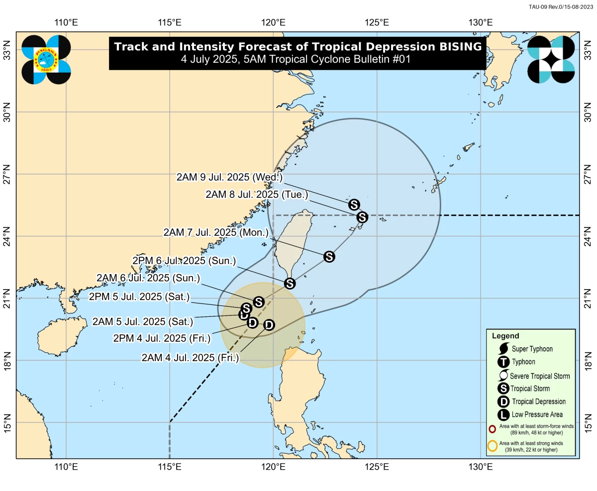
The Low-Pressure Area (LPA) located west of Cagayan has developed into a tropical depression and was named “Bising,” the Philippine Atmospheric, Geophysical and Astronomical Services Administration (PAGASA) reported on Friday, July 4.
As of 3 a.m., the center of tropical depression Bising was located 200 kilometers west-northwest of Calayan, Cagayan.
It has maximum sustained winds of 45 kilometers per hour (kph) near the center and gustiness of up to 55 kph. It is moving southwestward at 20 kph.
PAGASA weather specialist Loriedin de la Cruz-Galicia said Bising is expected to move slowly westward within the next 12 hours and may exit the Philippine Area of Responsibility (PAR) later today.
The system is forecast to turn northeastward afterward, with a possible reentry into the western PAR by Sunday, July 6.
“The forecast track is highly uncertain, and a possible southward shift resulting in hoisting of Wind Signal No. 2 over Batanes and Babuyan Islands is not ruled out,” dela Cruz-Galicia said.
Bising may intensify into a tropical storm by Saturday afternoon or evening and could continue to strengthen while over the waters south of Taiwan.
Wind signals
Tropical Cyclone Wind Signal No. 1 has been raised over the western portion of the Babuyan Islands, particularly Calayan and Dalupiri Islands, and the northwestern part of Ilocos Norte, including the municipalities of Pagudpud, Bangui, Burgos, Pasuquin, and Dumalneg.
PAGASA said minimal to minor impacts from strong winds are possible in these areas.
Rainfall forecast
PAGASA said Bising is expected to bring significant rainfall over parts of Northern Luzon.
On Friday, rainfall ranging from 100 to 200 mm (heavy to intense) is expected in Ilocos Norte, while amounts between 50 and 100 mm (moderate to heavy) may be experienced in Batanes, Cagayan, Apayao, Abra, and Kalinga.
On Saturday, rainfall of 50 to 100 mm is forecast in Batanes, Cagayan, Apayao, and Ilocos Norte.
By Sunday, heavier rains are expected in Batanes and the Babuyan Islands, with 100 to 200 mm projected, while Ilocos Norte may receive 50 to 100 mm.
In addition to Bising, the enhanced southwest monsoon (habagat) is expected to continue bringing widespread rain.
On Friday, heavy to intense rains are expected in Pangasinan, Zambales, and Bataan.
Moderate to heavy rains may affect Metro Manila, Ilocos Sur, La Union, Benguet, Ifugao, Mountain Province, Tarlac, Pampanga, Bulacan, Rizal, Laguna, Cavite, Batangas, and Occidental Mindoro.
On Saturday, moderate to heavy rainfall is still expected in Ilocos Sur, La Union, Pangasinan, Abra, Benguet, Zambales, and Bataan.
By Sunday, moderate to heavy rains may continue over Ilocos Sur, La Union, and Pangasinan.
PAGASA advised residents in affected areas to stay alert for possible flooding and landslides.