


Manila Bulletin
 Philippines
National
PANaHON 3D: PAGASA's enhanced weather monitoring tool offers unified, real-time information
Philippines
National
PANaHON 3D: PAGASA's enhanced weather monitoring tool offers unified, real-time information
Philippines
National
PANaHON 3D: PAGASA's enhanced weather monitoring tool offers unified, real-time information
PANaHON 3D: PAGASA's enhanced weather monitoring tool offers unified, real-time information
Published Jun 16, 2025 02:26 pm


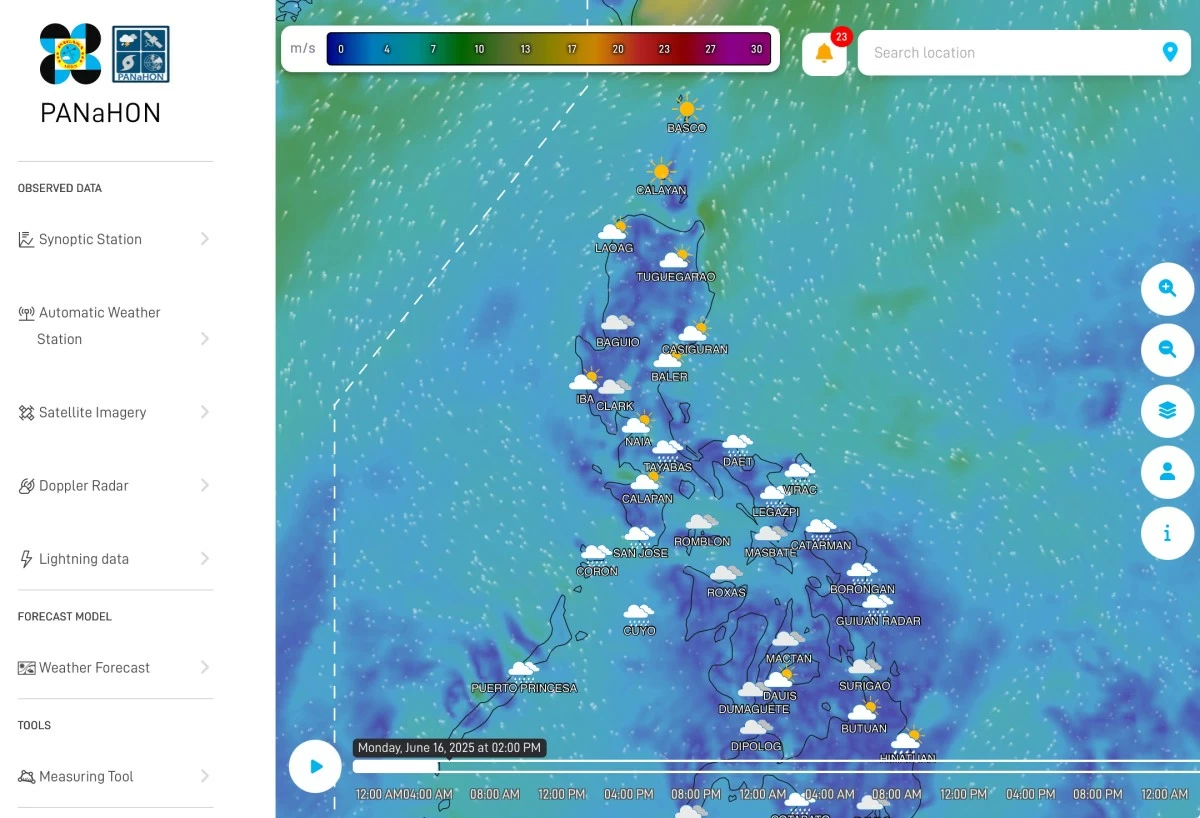
PAGASA National Hydro-Met Observing Network (PANaHON 3D)
The Philippine Atmospheric, Geophysical and Astronomical Services Administration (PAGASA) has rolled out key upgrades to its PANaHON 3D Web-Based Decision Support Information System, an interactive platform designed to provide more accurate and accessible weather information to disaster managers and local government units nationwide.
PANaHON, which stands for PAGASA National Hydro-Met Observing Network, now features integrated gridded forecasts that deliver precise weather data, such as rainfall accumulation, temperature, wind, and pressure, for any location, even those without nearby PAGASA weather stations.
Users can explore this data through clickable map grids, time-sliders, and location-based search functions, offering a more detailed and user-friendly experience.
One of the most significant improvements is the consolidation of all regional weather warnings into a centralized alert system.
The system displays real-time hazards on a color-coded interactive map to provide a unified view of warnings issued by all five PAGASA Regional Services Divisions, allowing disaster managers and local government units to monitor weather hazards more efficiently using a single platform.
“PANaHON now acts as a one-stop shop for all official weather warnings across the country,” said PAGASA senior weather specialist Raymond Ordinario.
He explained that one of the salient features of PANaHON is its integration of official PAGASA warnings and near-real-time observation data, a level of reliability and immediacy not available in other platforms such as the Windy app.
“This interactive map can provide you with all warnings from PAGASA, as well as available observation data. This information becomes readily accessible to the public. Our near-real-time observations use ground information, radars, and satellites. That’s something other platforms don’t have,” Ordinario said.
He also highlighted the platform’s role in ensuring the accuracy of information disseminated by PAGASA.
“One thing we ensure is that all official information will be coming from this site. So it won’t become a source of fake news,” he added.
PAGASA Administrator Dr. Nathaniel Servando emphasized the importance of these upgrades in supporting local planning, risk reduction, and disaster preparedness initiatives.
The relaunch coincides with Typhoon and Flood Awareness Week, observed every third week of June to promote readiness against weather-related hazards.
The theme for this year’s celebration is “Kahandaan sa Bagyo at Baha, Solusyon sa Ligtas na Bayan” (Being Ready for Typhoons and Floods is the Key to a Safe Community).
“This platform will help disaster managers and local government units access timely and reliable weather data essential for decision-making during emergencies,” Servando said.
The upgraded PANaHON platform continues to undergo development based on user feedback to further improve its features and accessibility.
PAGASA encourages disaster managers and local government officials to utilize this tool as an alternative source of official weather information, especially during severe weather events.