


 Philippines
National
Violent winds batter Batanes, Babuyan Islands as 'Julian' traverses Balintang Channel
Philippines
National
Violent winds batter Batanes, Babuyan Islands as 'Julian' traverses Balintang Channel
Violent winds batter Batanes, Babuyan Islands as 'Julian' traverses Balintang Channel


At A Glance
- Tropical Cyclone Wind Signal No. 4 remains hoisted over Batanes and the northern portion of Babuyan Islands, while Signal No. 3 is still in effect in the rest of Babuyan Islands and northeastern portion of mainland Cagayan.
- PAGASA said Julian may continue to move west-northwestward at a speed of 10 kilometers per hour (kph) and may still make landfall over Batanes or Babuyan Islands on Monday morning or afternoon.
- It may continue to intensify and reach super typhoon status by Tuesday, Oct. 1.
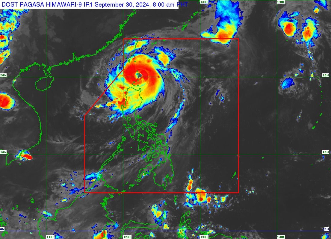
Typhoon “Julian” (international name “Krathon”) has unleashed violent winds in extreme Northern Luzon as it moved over the Balintang Channel on Monday morning, Sept. 30, said the Philippine Atmospheric, Geophysical and Astronomical Services Administration (PAGASA) in its latest bulletin.
As of 8 a.m., Tropical Cyclone Wind Signal No. 4 remains hoisted over Batanes and the northern portion of Babuyan Islands, while Signal No. 3 is still in effect in the rest of Babuyan Islands and northeastern portion of mainland Cagayan.
The rest of mainland Cagayan, Apayao, northern part of Abra, northern portion of Kalinga, Ilocos Norte, and northern part of Ilocos Sur remain under Signal No. 2.
Areas under Signal No. 1 are the rest of Ilocos Sur, La Union, Pangasinan, the rest of Abra, the rest of Kalinga, Ifugao, Mountain Province, Benguet, Isabela, Nueva Vizcaya, Quirino, Aurora, northern and eastern portions of Nueva Ecija, and Polillo Islands.
PAGASA said Julian may also bring intense to torrential rainfall (more than 200 millimeters) to Batanes, Babuyan Islands, and Ilocos Norte, while heavy to intense rainfall (100 to 200 millimeters) may prevail over mainland Cagayan, Ilocos Sur, La Union, Apayao, Abra, and Benguet.
Meanwhile, moderate to heavy rainfall (50 to 100 millimeters) may persist in Pangasinan, Zambales, Bataan, and the rest of Cordillera Administrative Region.
PAGASA said the trough or extension of Julian may also bring scattered rain showers and thunderstorms to Metro Manila, Cavite, Laguna, Batangas, Rizal, Quezon, Oriental Mindoro, Occidental Mindoro, Marinduque, Camarines Norte, Camarines Sur, and the rest of Central Luzon.
The rest of the country will remain partly cloudy to cloudy with isolated rain showers due to localized thunderstorms.
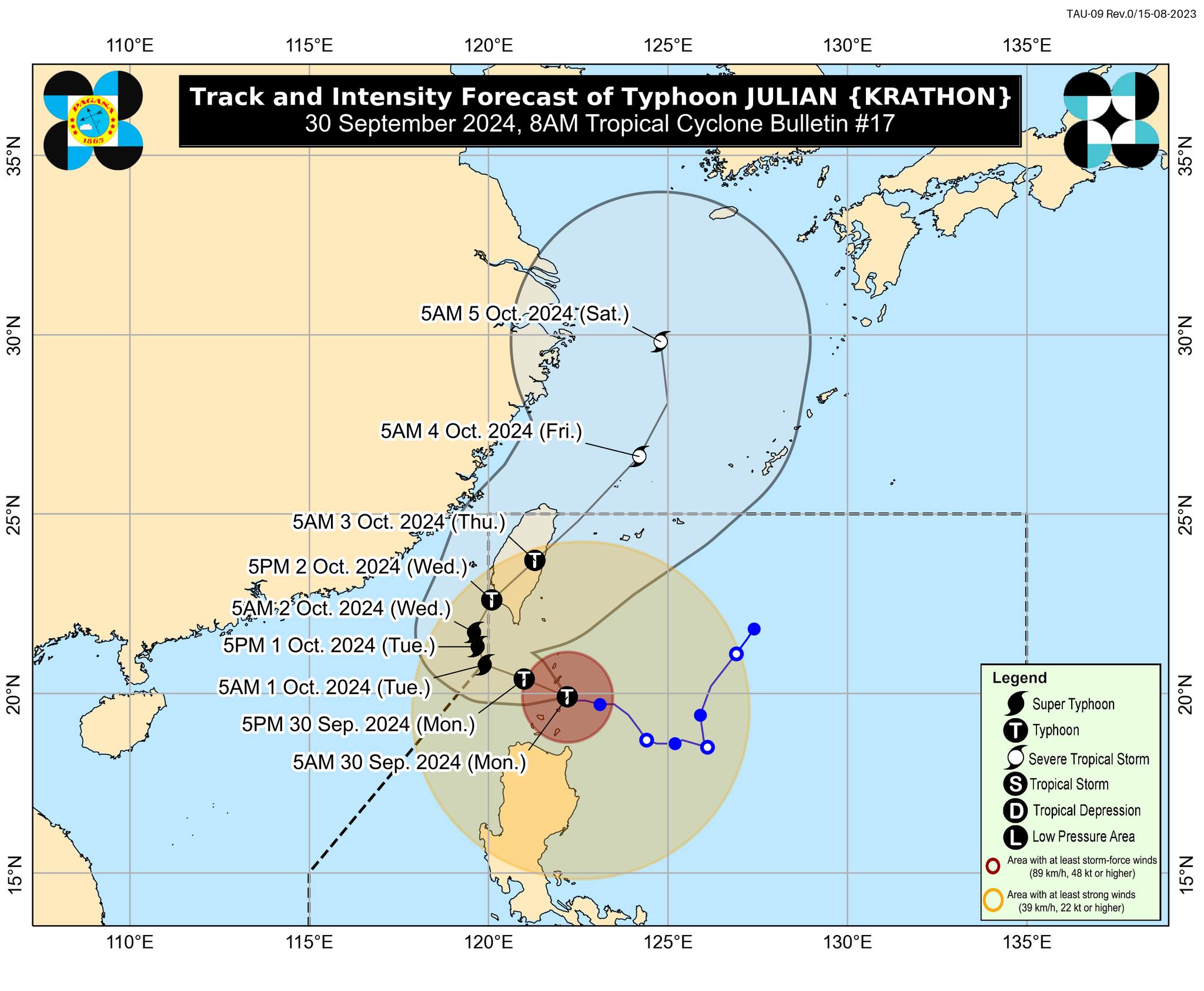
PAGASA said Julian may continue to move west-northwestward at a speed of 10 kilometers per hour (kph) and may still make landfall over Batanes or Babuyan Islands on Monday morning or afternoon.
Currently, it has maximum sustained winds of 175 kph near the center and gusts of up to 215 kph. However, it may continue to intensify and reach super typhoon status by Tuesday, Oct. 1.
Based on the latest forecast track, Julian may briefly exit the Philippine Area of Responsibility (PAR) by Tuesday before re-entering on Wednesday, Oct. 2.
Afterwards, the typhoon will gradually accelerate northeastward toward the East China Sea and exit the PAR on Thursday morning or afternoon, Oct. 4.