ADVERTISEMENT

PAGASA raises Signal No. 3 over a portion of Babuyan Islands

Published Sep 29, 2024 03:57 am

At A Glance

  • The highest wind warning that may be issued during the occurrence of Julian is Signal No. 4.
  • The track forecast shows a landfall or close approach scenario by Monday, Sept. 30 over Batanes or Babuyan Islands is "highly likely."
  • The possibility of reaching super typhoon category is not ruled out.
IMG_4350.jpeg
Satellite image of Severe Tropical Storm “Julian” (international name “Krathon” courtesy of PAGASA

Tropical Cyclone Wind Signal No. 3 was raised over the northeastern part of Babuyan Islands before Sunday noon, Sept. 29, as Severe Tropical Storm “Julian” (international name “Krathon”) moved closer to extreme Northern Luzon.

PAGASA also hoisted Signal No. 2 over Batanes, the northeastern portion of mainland Cagayan (Santa Ana), and the rest of Babuyan Islands (Camiguin Island, Calayan Island, Dalupiri Island, Fuga Island), and Signal No. 1 over the rest of Cagayan, Isabela, Apayao, Abra, Kalinga, Mountain Province, Ifugao, Ilocos Norte, Ilocos Sur, the northern portion of Benguet (Bakun, Mankayan, Buguias), and the northern portion of Aurora (Dilasag, Casiguran).

It said the highest wind warning that may be issued during the occurrence of Julian is Signal No. 4.

As of 11 a.m., the center of the severe tropical storm was located 285 kilometers east of Aparri, Cagayan. It further intensified with maximum sustained winds of 110 kilometers per hour (kph) near the center and gusts of up to 135 kph.

PAGASA said Julian is expected to move generally west-northwestward to northwestward until Tuesday, Oct. 1 toward the Batanes-Babuyan Islands area, before accelerating north to north-northeastward over the waters east of Taiwan on Tuesday afternoon.

The track forecast shows a landfall or close approach scenario by Monday, Sept. 30 over Batanes or Babuyan Islands is “highly likely.”

IMG_4351.jpeg
Severe Tropical Storm Julian’s projected track and intensity (Courtesy of PAGASA)

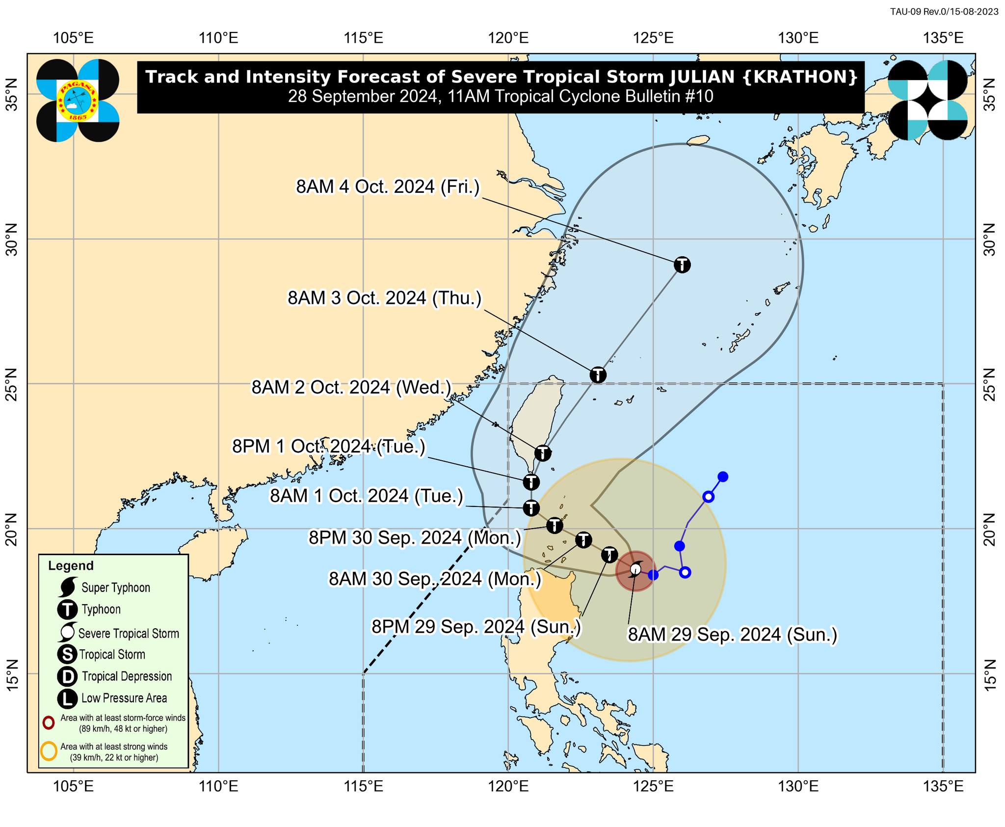
PAGASA also said Julian will continue to intensify throughout the forecast period and is expected to reach typhoon category by Sunday evening.

“There is a high chance of rapid intensification, and the possibility of reaching super typhoon category is not ruled out,” it added.

Julian will be closest to Batanes and Babuyan Islands at or near its peak intensity.

Over the next 24 hours, stormy weather is expected in Batanes and Babuyan Islands, while rainy and gusty conditions may prevail in mainland Cagayan, Isabela, Apayao, and Ilocos Norte.

Cloudy skies with scattered rains and thunderstorms may also affect Central Luzon, Quezon, Camarines Norte, Camarines Sur, Catanduanes, the rest of Ilocos Region, the rest of Cordillera Administrative Region, and the rest of Cagayan Valley.

PAGASA said the trough or extension of Julian may also bring partly cloudy to cloudy skies with isolated rain showers or thunderstorms to Metro Manila and the rest of Luzon.

The rest of the country will also be partly cloudy to cloudy with isolated rain showers due to localized thunderstorms.

Related Tags

Signal No. 3 PAGASA Severe Tropical Storm Julian
ADVERTISEMENT
.most-popular .layout-ratio{ padding-bottom: 79.13%; } @media (min-width: 768px) and (max-width: 1024px) { .widget-title { font-size: 15px !important; } }

{{ articles_filter_1561_widget.title }}

.most-popular .layout-ratio{ padding-bottom: 79.13%; } @media (min-width: 768px) and (max-width: 1024px) { .widget-title { font-size: 15px !important; } }

{{ articles_filter_1562_widget.title }}

.most-popular .layout-ratio{ padding-bottom: 79.13%; } @media (min-width: 768px) and (max-width: 1024px) { .widget-title { font-size: 15px !important; } }

{{ articles_filter_1563_widget.title }}

{{ articles_filter_1564_widget.title }}

.mb-article-details { position: relative; } .mb-article-details .article-body-preview, .mb-article-details .article-body-summary{ font-size: 17px; line-height: 30px; font-family: "Libre Caslon Text", serif; color: #000; } .mb-article-details .article-body-preview iframe , .mb-article-details .article-body-summary iframe{ width: 100%; margin: auto; } .read-more-background { background: linear-gradient(180deg, color(display-p3 1.000 1.000 1.000 / 0) 13.75%, color(display-p3 1.000 1.000 1.000 / 0.8) 30.79%, color(display-p3 1.000 1.000 1.000) 72.5%); position: absolute; height: 200px; width: 100%; bottom: 0; display: flex; justify-content: center; align-items: center; padding: 0; } .read-more-background a{ color: #000; } .read-more-btn { padding: 17px 45px; font-family: Inter; font-weight: 700; font-size: 18px; line-height: 16px; text-align: center; vertical-align: middle; border: 1px solid black; background-color: white; } .hidden { display: none; }
function initializeAllSwipers() { // Get all hidden inputs with cms_article_id document.querySelectorAll('[id^="cms_article_id_"]').forEach(function (input) { const cmsArticleId = input.value; const articleSelector = '#article-' + cmsArticleId + ' .body_images'; const swiperElement = document.querySelector(articleSelector); if (swiperElement && !swiperElement.classList.contains('swiper-initialized')) { new Swiper(articleSelector, { loop: true, pagination: false, navigation: { nextEl: '#article-' + cmsArticleId + ' .swiper-button-next', prevEl: '#article-' + cmsArticleId + ' .swiper-button-prev', }, }); } }); } setTimeout(initializeAllSwipers, 3000); const intersectionObserver = new IntersectionObserver( (entries) => { entries.forEach((entry) => { if (entry.isIntersecting) { const newUrl = entry.target.getAttribute("data-url"); if (newUrl) { history.pushState(null, null, newUrl); let article = entry.target; // Extract metadata const author = article.querySelector('.author-section').textContent.replace('By', '').trim(); const section = article.querySelector('.section-info ').textContent.replace(' ', ' '); const title = article.querySelector('.article-title h1').textContent; // Parse URL for Chartbeat path format const parsedUrl = new URL(newUrl, window.location.origin); const cleanUrl = parsedUrl.host + parsedUrl.pathname; // Update Chartbeat configuration if (typeof window._sf_async_config !== 'undefined') { window._sf_async_config.path = cleanUrl; window._sf_async_config.sections = section; window._sf_async_config.authors = author; } // Track virtual page view with Chartbeat if (typeof pSUPERFLY !== 'undefined' && typeof pSUPERFLY.virtualPage === 'function') { try { pSUPERFLY.virtualPage({ path: cleanUrl, title: title, sections: section, authors: author }); } catch (error) { console.error('ping error', error); } } // Optional: Update document title if (title && title !== document.title) { document.title = title; } } } }); }, { threshold: 0.1 } ); function showArticleBody(button) { const article = button.closest("article"); const summary = article.querySelector(".article-body-summary"); const body = article.querySelector(".article-body-preview"); const readMoreSection = article.querySelector(".read-more-background"); // Hide summary and read-more section summary.style.display = "none"; readMoreSection.style.display = "none"; // Show the full article body body.classList.remove("hidden"); } document.addEventListener("DOMContentLoaded", () => { let loadCount = 0; // Track how many times articles are loaded const offset = [1, 2, 3, 4, 5, 6, 7, 8, 9, 10]; // Offset values const currentUrl = window.location.pathname.substring(1); let isLoading = false; // Prevent multiple calls if (!currentUrl) { console.log("Current URL is invalid."); return; } const sentinel = document.getElementById("load-more-sentinel"); if (!sentinel) { console.log("Sentinel element not found."); return; } function isSentinelVisible() { const rect = sentinel.getBoundingClientRect(); return ( rect.top < window.innerHeight && rect.bottom >= 0 ); } function onScroll() { if (isLoading) return; if (isSentinelVisible()) { if (loadCount >= offset.length) { console.log("Maximum load attempts reached."); window.removeEventListener("scroll", onScroll); return; } isLoading = true; const currentOffset = offset[loadCount]; window.loadMoreItems().then(() => { let article = document.querySelector('#widget_1690 > div:nth-last-of-type(2) article'); intersectionObserver.observe(article) loadCount++; }).catch(error => { console.error("Error loading more items:", error); }).finally(() => { isLoading = false; }); } } window.addEventListener("scroll", onScroll); });

Sign up by email to receive news.