


PAGASA: 'Julian' now a tropical storm
Possibility of reaching super typhoon category not ruled out


The Philippine Atmospheric, Geophysical, and Astronomical Services Administration (PAGASA) announced on Saturday, Sept. 28, that Tropical Depression Julian has intensified into a tropical storm.
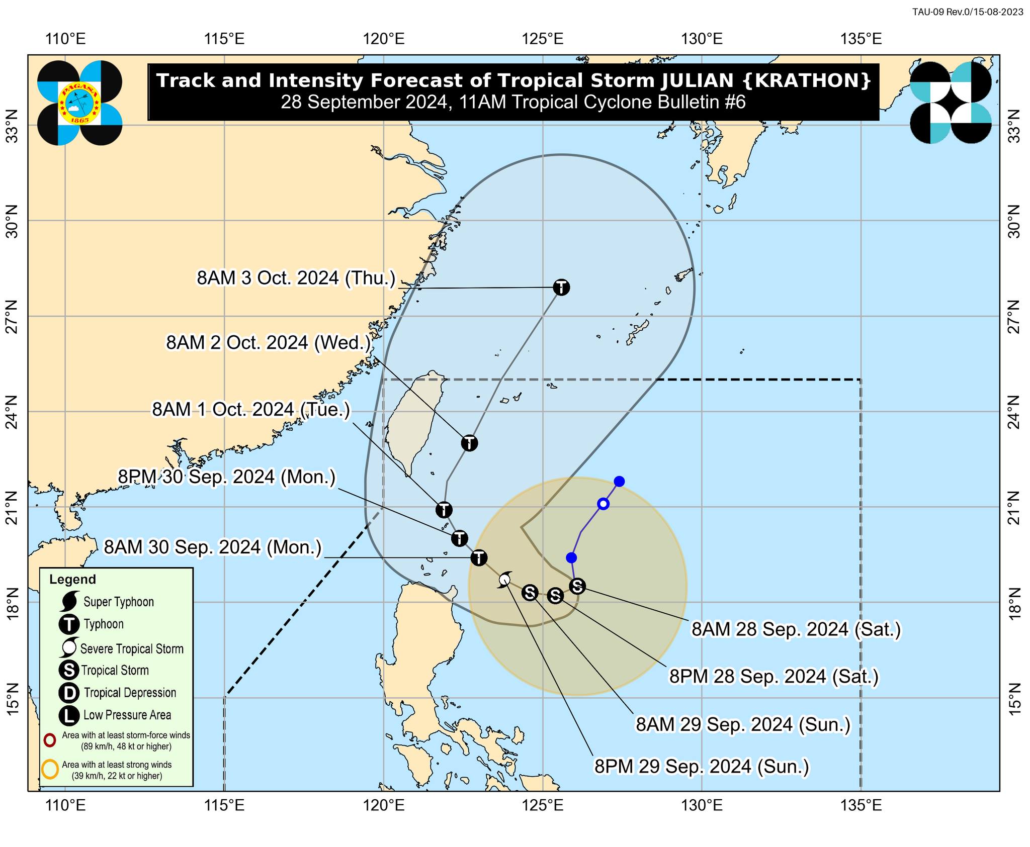
In its 11 a.m. bulletin, PAGASA stated that the center of Tropical Storm (TS) Julian, with the international name Krathon, was located 465 km east of Aparri, Cagayan.
“Julian” has maximum sustained winds of 65 km/h near the center, gusts of up to 80 km/h, and a central pressure of 1000 hPa. It is slowly moving south-southeastward.
PAGASA reported that strong gale-force winds extending outward up to 380 km from the center are expected.
Strong winds are anticipated in some areas of Luzon, particularly those under Tropical Cyclone Wind Signal (TCWS) No. 1, which include Batanes, Cagayan (including the Babuyan Islands), and the northern and eastern portions of Isabela (San Pablo, Divilacan, Maconacon, Palanan, Cabagan, Santa Maria, Tumauini, Ilagan City, San Mariano, Santo Tomas, Delfin Albano, Dinapigue), Apayao, and Ilocos Norte.
PAGASA noted that minimal to minor impacts from strong winds are possible in areas under Wind Signal No. 1.
Track and outlook
PAGASA stated that the highest Wind Signal that may be hoisted during the occurrence of “Julian” is Wind Signal No. 4.
“Julian” is expected to bring strong to gale-force gusts over Aurora, CALABARZON, Romblon, and the Bicol Region on Sept. 29, and over Aurora, Pangasinan, Zambales, Bataan, Metro Manila, CALABARZON, Romblon, and the Bicol Region on Sept. 30, especially in coastal and upland areas exposed to the winds.
PAGASA indicated that “Julian” is expected to move west-southwestward or westward on Sept. 28, then generally northwestward on Sept. 29.
By Sept. 30, PAGASA noted that “Julian” will move toward the Batanes-Babuyan Islands area before accelerating north-northeastward over the waters east of Taiwan on Oct. 1.
PAGASA indicated that based on the track forecast, a “landfall or close approach scenario” over Batanes and/or the Babuyan Islands on Sept. 30 is “not ruled out.”
Moreover, PAGASA stated that TS Julian will continue to intensify throughout the forecast period and is expected to reach the typhoon category on Sept. 30.
“There is an increasing likelihood of rapid intensification, and the possibility of reaching the super typhoon category is not ruled out,” PAGASA said. “This tropical cyclone will be closest to Batanes and/or the Babuyan Islands at or near peak intensity,” it added.
RELATED STORY:
https://mb.com.ph/2024/9/28/julian-maintains-strength-PAGASA