


'Julian' may make landfall in Batanes as a typhoon — PAGASA
Wind Signal No. 3 or 4 may be raised


At A Glance
- Tropical Cyclone Wind Signal No. 1 has been raised over Cagayan, including Babuyan Islands, northeastern portion of Isabela, and eastern portion of Apayao in anticipation of strong winds.
- Wind warnings may be upgraded to Signal No. 3 or 4 due to Julian's anticipated close approach.
- As rapid intensification may occur, the possibility of reaching the super typhoon category is not ruled out.

The Philippine Atmospheric, Geophysical and Astronomical Services Administration (PAGASA) said on Friday, Sept. 27, that Tropical Depression “Julian” could make landfall in Batanes as a typhoon by Monday, Sept. 30.
PAGASA said the tropical depression may follow a looping path while remaining over the waters east of Batanes and Cagayan over the next five days.
Julian may intensify into a tropical storm by Saturday morning and become a typhoon by Sunday, Sept. 29.
“As rapid intensification is increasingly likely, the possibility of reaching the super typhoon category is not ruled out,” PAGASA said.
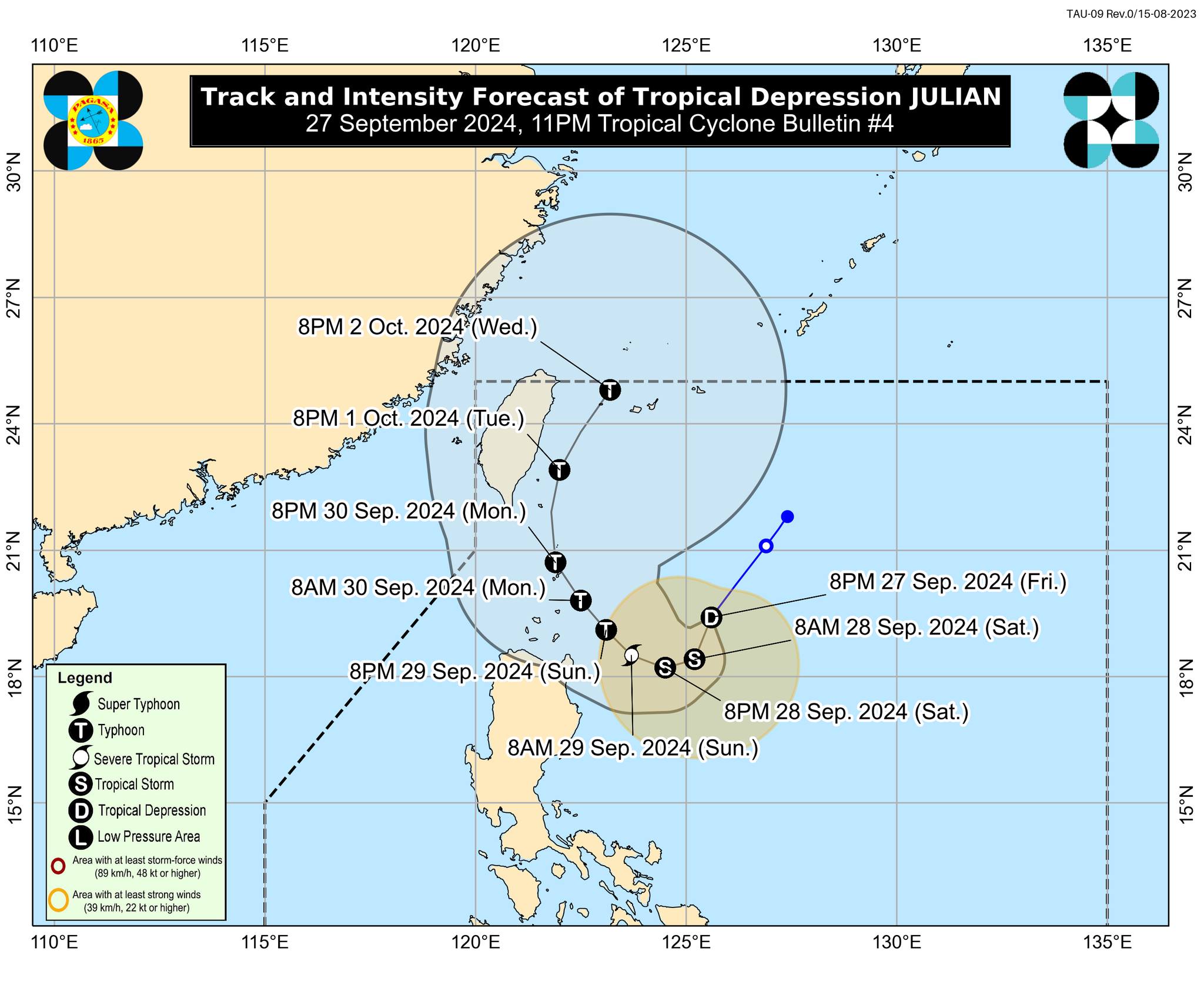
As of 11 p.m. on Friday, Tropical Depression Julian has maximum sustained winds of 55 kilometers per hour (kph) near the center and gusts of up to 70 kph.
It was located 400 kilometers east-southeast of Basco, Batanes, or 435 kilometers east of Calayan, Cagayan, and is expected to move south-southwestward at 20 kph.
“The track forecast will shift westward in the succeeding bulletins, bringing the projected path of Julian closer to extreme northern Luzon,” PAGASA said.
As of Friday, Tropical Cyclone Wind Signal No. 1 has been raised over Cagayan, including Babuyan Islands, northeastern portion of Isabela, and eastern portion of Apayao in anticipation of strong winds.
PAGASA said the wind warnings may be upgraded to Signal No. 3 or 4 due to Julian’s anticipated close approach in the next few days.
Julian may also bring moderate to heavy rainfall to Cagayan, Isabela, Batanes, Apayao, and Ilocos Norte by Saturday, Sept. 28,
By Sunday, Sept. 29, Cagayan, Batanes, Apayao, and Ilocos Norte may experience heavy to intense rainfall, while Isabela, the rest of Ilocos Region, and Cordillera Administrative Region may receive moderate to heavy rainfall.
“Under these conditions, flooding and rain-induced landslides are possible, especially in areas that are highly or very highly susceptible to these hazards as identified in hazard maps and areas with significant antecedent rainfall,” PAGASA warned.