Why is the Philippines seeing many cyclones in September? PAGASA explains
At A Glance
- PAGASA observed higher-than-normal sea surface temperatures across the Western North Pacific, resembling La Niña conditions, which led to the formation of more tropical cyclones in September.
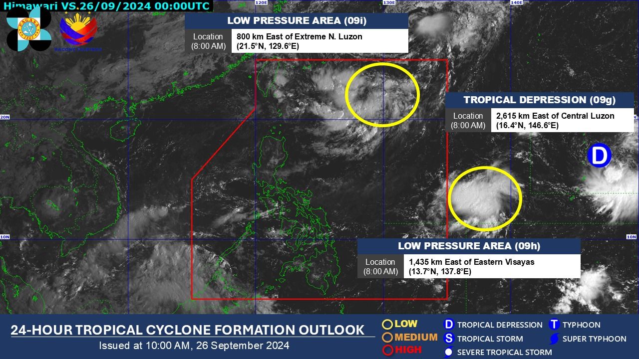
- The potential sixth tropical cyclone this month may develop by the weekend.
- The next tropical cyclone inside the PAR will be named "Julian."

Five tropical cyclones entered or formed within the Philippine Area of Responsibility (PAR) this September, with a sixth potentially developing before the end of the month.
This number surpassed the two to three tropical cyclones that the Philippine Atmospheric, Geophysical and Astronomical Services Administration (PAGASA) had estimated for the month.
During a climate forum on Wednesday, Sept. 25, PAGASA explained the factors at play for the increase in cyclonic activity.
“‘Nung August wala tayong gaanong bagyo pero ‘yung energy balance ‘yun eh. So pagdating ng susunod na buwan, like for this case September, maraming bagyo (In August, we didn’t have many storms, but that’s due to the energy balance. So, as we move into the following month, like in this case, September, there are many storms),” PAGASA-Climatology and Agrometeorology Division Chief Thelma Cinco said.
In August, the country was affected by only one cyclone, Tropical Storm Dindo (Jongdari).
She explained that PAGASA observed higher-than-normal sea surface temperatures across the Western North Pacific, resembling La Niña conditions, which led to the formation of more tropical cyclones in September.
“So nakita natin na mostly near land area ‘yung mga nabubuong low pressure area tapos ang bibilis kasi mas mainit kaysanormal yung na-observe natin na sea surface temperate near Philippine Sea (So we saw that most of the developing low pressure areas are near land, and they are forming rapidly due to the warmer-than-normal sea surface temperatures observed near the Philippine Sea),” she added.
Looming La Niña
Cinco said an increase in sea surface temperatures is one of the indicators of a La Niña.
In its La Niña update, PAGASA said El Niño Southern Oscillation (ENSO)-neutral conditions—where neither La Niña nor El Niño is present—are currently observed in the tropical Pacific but are “showing signs of La Niña development.”
“Most climate models, combined with expert judgments, suggest a 71 percent chance of La Niña forming in the September-October-November 2024 season and will likely persist until the first quarter (January-February-March) of 2025,” it said.
“With these model probabilities, borderline La Niña or La Niña-like conditions will be likely during the forecast period,” it added.
However, Cinco noted that even during El Niño or neutral conditions, a month with few tropical cyclones can still be followed by a month with many weather disturbances.
Weather Specialist Joey Figuracio noted that in September 2022, during La Niña, there were five tropical cyclone occurrences, and the same number was recorded in September 1956, also during La Niña.
PAGASA Senior Weather Specialist Rusy Abastillas added that in 1978 and 1993, there were six cyclones in one month during ENSO-neutral conditions, while in 2009, five tropical cyclones occurred in one month during an El Niño event.
In 2019, there were also five cyclones in just one month under ENSO-neutral conditions.
Figuracion concluded that there is no consistent pattern as these occurrences can happen regardless of whether it is La Niña, El Niño, or neutral conditions.
6th cyclone
PAGASA said on Thursday, Sept. 26 that the potential sixth tropical cyclone this month may develop by the weekend.
A Low Pressure Area (LPA) formed from a cluster of clouds on Thursday morning, located 800 kilometers east of extreme northern Luzon.
This potential cyclone follows Severe Tropical Storm Enteng (Yagi), Tropical Storm Ferdie (Bebinca), Tropical Depression Gener, Tropical Storm Helen (Pulasan), and Tropical Depression Igme.
The next tropical cyclone inside the PAR will be named “Julian.”