ADVERTISEMENT
970x220
.navbar-nav.header-menu { width: 100%; justify-content: center; } .tab-menu-outers .nav-item{ width: unset; } .tab-bar-social.mt-5 { margin-top: 0 !important; } .second-header-menu { margin-top: 27px; padding: 12px 0; border-top: 1px solid #C3C1AE; border-bottom: 1px solid #C3C1AE; } .third-header-menu{ padding: 12px 0; } .bottom-header-menu { margin-right: 25px; text-decoration: none; font-family: "Canicule Display v0.3 Trial" , serif; font-weight: 500; font-size: 15px; line-height: 16px; color: black; } .bottom-header-menu:hover { color: #0A58CA !important; } header .time-date-section { display: flex; align-items: end; } header .mb-header-center .align-items-center .col-3 , header .mb-header-center .align-items-center .col-6, header .top-header-container .col-md-6{ z-index: 100; } header .desktop-menu-bar li:hover a{ background: transparent; color: #2E3192 !important; } @media(max-width: 767px) { header.header.mb-header{ display:none; } .second-header-menu .justify-content-center{ justify-content: start !important; } .second-header-menu ul , .third-header-menu ul{ display: grid; grid-template-columns: 1fr 1fr; width: 100%; } }

Heavy rains persist as ‘Enteng’ maintains strength, advances slowly north-northwestward

Published Sep 02, 2024 05:02 am  |  Updated Sep 02, 2024 05:02 am

At A Glance

  • Tropical Storm Enteng is expected to make landfall over Isabela or Cagayan on Monday afternoon or evening, Sept. 2 although a landfall over northern Aurora remains a possibility.
  • PAGASA Senior Weather Specialist Glaiza Escullar said that wind signals may remain in effect until Friday, Sept. 6, and that storm-enhanced southwest monsoon, or “habagat,” rains are expected to continue for the next three to five days.
IMG_4196.jpeg
Satellite image of Tropical Storm Enteng (international name Yagi)

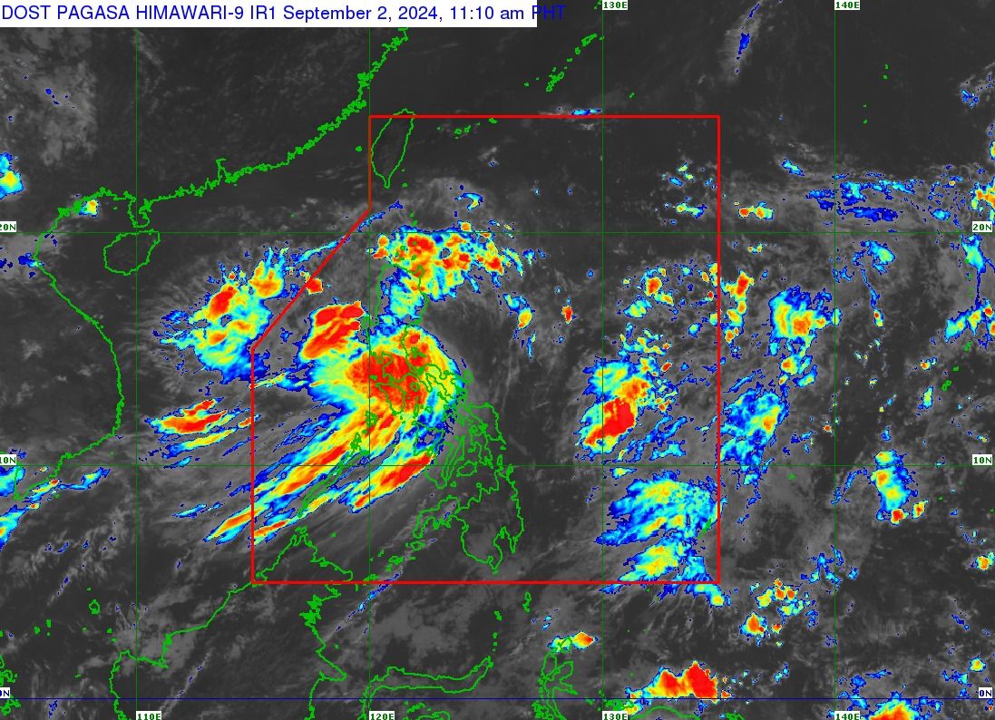
Tropical Storm “Enteng” (international name “Yagi”) maintained its strength while slowly shifting north-northwest over the sea east of the Polillo Islands on Monday, Sept. 2.

The Philippine Atmospheric, Geophysical and Astronomical Services Administration (PAGASA), in its 11 a.m. bulletin, said the tropical storm has maintained its maximum sustained winds of 75 kilometers per hour (kph) near the center and gusts of up to 90 kph, moving at a speed of 15 kph.

Enteng is expected to make landfall over Isabela or Cagayan Monday afternoon or evening, although a landfall over northern Aurora remains a possibility.

Starting early Tuesday morning, Sept. 3, PAGASA forecasts that the storm will shift to a more northwestward or west-northwestward path across mainland Northern Luzon, emerging over the Luzon Strait by late morning. 

From Tuesday to mid-Thursday, Sept. 5, Enteng is expected to move westward over the Luzon Strait and the West Philippine Sea. 

PAGASA said the storm may exit the Philippine Area of Responsibility by Wednesday, Sept. 4.

IMG_4197.jpeg

Wind warnings still up

In the PAGASA press conference on Monday, Senior Weather Specialist Glaiza Escullar said that wind signals may remain in effect “until Friday, Sept. 6,” and that storm-enhanced southwest monsoon, or “habagat,” rains are expected to continue for the “next three to five days.”

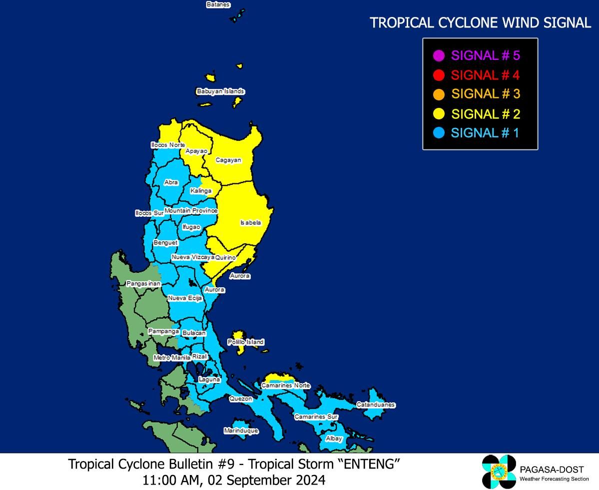
As of Monday, Tropical Cyclone Wind Signal No. 2 remains hoisted over the northern portion of Ilocos Norte, Apayao, the eastern portion of Kalinga, Cagayan including Babuyan Islands, Isabela, Quirino, the northern portion of Aurora, Polillo Islands, and the northern portion of Camarines Norte.

Signal No. 1 is still in place in Metro Manila, Batanes, the rest of Ilocos Norte, Ilocos Sur, La Union, eastern portion of Pangasinan, Abra, the rest of Kalinga, Mountain Province, Ifugao, Benguet, Nueva Vizcaya, the rest of Aurora, Nueva Ecija, eastern portion of Pampanga, eastern portion of Bulacan, the rest of Quezon, Rizal, Laguna, eastern portion of Batangas, Marinduque, the rest of Camarines Norte, Camarines Sur, Catanduanes, and Albay.

PAGASA has not yet ruled out the possibility that the highest wind signal raised during the passage of Enteng will be Signal No. 3.

Heavy rains due to ‘Enteng’, ‘habagat’

Until Tuesday noon, rainfall is expected to be heavy to intense (100 to 200 millimeters) in the northern and central portions of Quezon including Polillo Islands, Rizal, Laguna, Metro Manila, Cavite, Zambales, Bataan, Nueva Ecija, eastern portion of Bulacan, Aurora, eastern portion of Isabela, Cagayan including Babuyan Islands, and Benguet. 

Areas with moderate to heavy rains (50 to 100 millimeters) include Marinduque, Romblon, Camarines Norte, Cavite, Ilocos Region, the rest of Quezon, Batangas, and the rest of Cordillera Administrative Region, Cagayan Valley, and Central Luzon.

From Tuesday noon to Wednesday noon, heavy to intense rainfall may persist in Ilocos Sur and Abra, while Ilocos Sur, La Union, Pangasinan, and Benguet may receive moderate to heavy rainfall.

The habagat may also bring heavy to intense rains to Occidental Mindoro, Oriental Mindoro, and northern Palawan, including Calamian, Cuyo, and Cagayancillo Islands until Monday evening.

Meanwhile, moderate to heavy rains are likely over the rest of Palawan.

By Tuesday, heavy to intense monsoon rains may persist in Occidental Mindoro, northern Palawan, including Calamian, Cuyo, and Cagayancillo Islands, Zambales, and Bataan, while moderate to heavy rains may prevail over Metro Manila, Cavite, Laguna, Batangas, Rizal, Quezon, the rest of Palawan, Romblon, Tarlac, Pampanga, Nueva Ecija, and Bulacan.

By Wednesday, heavy to intense monsoon rains may continue to affect Ilocos Region, Zambales, and Bataan.

Metro Manila, Cavite, Laguna, Batangas, Rizal, Tarlac, Pampanga, Nueva Ecija, Bulacan, Occidental Mindoro, Oriental Mindoro, Palawan, Romblon, and Antique may continue to experience moderate to heavy rains due to the habagat.

PAGASA warned that these conditions could cause flooding and rain-induced landslides, particularly in areas identified as highly vulnerable in official hazard maps and those that have recently received heavy rainfall.

Enteng may remain a tropical storm until Tuesday as it moves across mainland Northern Luzon, PAGASA said.

It may further intensify from Wednesday onwards, potentially reaching severe tropical storm status on Wednesday and typhoon status by Friday, it added.

Related Tags

signal no. 2 Habagat landfall Tropical Storm Enteng
ADVERTISEMENT
300x250
.most-popular .layout-ratio{ padding-bottom: 79.13%; } @media (min-width: 768px) and (max-width: 1024px) { .widget-title { font-size: 15px !important; } }

{{ articles_filter_1561_widget.title }}

.most-popular .layout-ratio{ padding-bottom: 79.13%; } @media (min-width: 768px) and (max-width: 1024px) { .widget-title { font-size: 15px !important; } }

{{ articles_filter_1562_widget.title }}

.most-popular .layout-ratio{ padding-bottom: 79.13%; } @media (min-width: 768px) and (max-width: 1024px) { .widget-title { font-size: 15px !important; } }

{{ articles_filter_1563_widget.title }}

{{ articles_filter_1564_widget.title }}

.mb-article-details { position: relative; } .mb-article-details .article-body-preview, .mb-article-details .article-body-summary{ font-size: 17px; line-height: 30px; font-family: "Libre Caslon Text", serif; color: #000; } .mb-article-details .article-body-preview iframe , .mb-article-details .article-body-summary iframe{ width: 100%; margin: auto; } .read-more-background { background: linear-gradient(180deg, color(display-p3 1.000 1.000 1.000 / 0) 13.75%, color(display-p3 1.000 1.000 1.000 / 0.8) 30.79%, color(display-p3 1.000 1.000 1.000) 72.5%); position: absolute; height: 200px; width: 100%; bottom: 0; display: flex; justify-content: center; align-items: center; padding: 0 72px 0 12px; } .read-more-background a{ color: #000; } .read-more-btn { padding: 17px 45px; font-family: Inter; font-weight: 700; font-size: 18px; line-height: 16px; text-align: center; vertical-align: middle; border: 1px solid black; background-color: white; } .hidden { display: none; }
function showArticleBody(button) { const article = button.closest("article"); const summary = article.querySelector(".article-body-summary"); const body = article.querySelector(".article-body-preview"); const readMoreSection = article.querySelector(".read-more-background"); // Hide summary and read-more section summary.style.display = "none"; readMoreSection.style.display = "none"; // Show the full article body body.classList.remove("hidden"); } document.addEventListener("DOMContentLoaded", () => { let loadCount = 0; // Track how many times articles are loaded const offset = [1, 2, 3, 4, 5, 6, 7, 8, 9, 10]; // The two offset values // changed to 10 from 1 , 2 const currentUrl = window.location.pathname.substring(1); let isLoading = false; // Prevent multiple calls if (!currentUrl) { console.log("Current URL is invalid."); return; } function isNearBottom() { return window.innerHeight + window.scrollY >= document.documentElement.scrollHeight - 100; } function onScroll() { if (isLoading) return; // Skip if already loading if (isNearBottom()) { if (loadCount >= offset.length) { console.log("Maximum load attempts reached."); window.removeEventListener("scroll", onScroll); return; } isLoading = true; // Set flag to prevent multiple calls const currentOffset = offset[loadCount]; window.loadMoreItems().then(() => { loadCount++; // Increment only after successful execution }).catch(error => { console.error("Error loading more items:", error); }).finally(() => { isLoading = false; // Reset flag after execution }); } } window.addEventListener("scroll", onScroll); }); // Mutation Observer for Newly Loaded Articles const observer = new MutationObserver(() => { const articles = document.querySelectorAll(".articles-observe"); if (articles.length > 0) { observeArticles(articles); } }); observer.observe(document.body, { childList: true, subtree: true }); // Intersection Observer for Updating URL function observeArticles(articles) { const intersectionObserver = new IntersectionObserver( (entries) => { entries.forEach((entry) => { if (entry.isIntersecting) { const newUrl = entry.target.getAttribute("data-url"); if (newUrl) { history.pushState(null, null, newUrl); } } }); }, { threshold: 0.1 } ); articles.forEach(article => intersectionObserver.observe(article)); }
.col-md-12.noPadding.col-xs-12:has(.mb-header-bottom) {padding: 0;} .bottom-footer {color: #fff;background-color: #2E3192;padding: 8px 0;} .bottom-footer .bottom-footer-menu {font-family: Inter;font-weight: 400;font-size: 12px;line-height: 16px;padding: 0px 10px !important;color: #fff !important;text-decoration: none; } .bottom-footer .container {display: flex;justify-content: space-between;align-items: center; } .bottom-footer p{font-family: "Inter";font-weight: 400;font-size: 12px;line-height: 16px;margin-bottom: 0;} .subscribe-button{position: absolute;bottom: 15%;right: 11%;} .subscribe-container {position: fixed;display: flex;align-items: center;background-color: white;height: 50px;border-radius: 50px;box-shadow: 1px 3px 8px 3px rgba(0, 0, 0, 0.2);width: 50px;overflow: hidden;transition: width 0.3s ease-in-out;text-decoration: none;white-space: nowrap; } .subscribe-icon {background-color: #2E3192;color: white;border-radius: 50%;width: 50px;height: 50px;display: flex;align-items: center;justify-content: center;font-size: 18px;flex-shrink: 0;transition: border-radius 0.3s ease-in-out; } .subscribe-text {font-size: 18px;font-weight: bold;color: black;margin-left: 0;margin-right: 0;width: 0;visibility: hidden;opacity: 0;transition: opacity 0.3s ease, width 0.3s ease;} .subscribe-container:hover {cursor: pointer;width: 170px;} .subscribe-container:hover .subscribe-icon {border-bottom-right-radius: 0;border-top-right-radius: 0;} .subscribe-container:hover .subscribe-text {visibility: visible;opacity: 1;margin-left: 10px;margin-right: 10px;width: auto;} h6.footer-heading{ font-weight: 700; } #bottom-footer ul li { display: flex; align-items: center; } @media screen and (min-width: 767px) and (max-width: 991px) { .bottom-footer p, .bottom-footer .bottom-footer-menu{ font-size: 9px; } } @media(max-width: 767px) { .bottom-footer .container {display: block;} .bottom-footer .container .justify-content-center{margin-top: 20px !important;} .bottom-footer .container .justify-content-center .list-group{ width: 100%; display: grid; row-gap: 10px; grid-template-columns: 1fr 1fr 1fr; justify-content: unset; } .bottom-footer p{font-size: 10px;} .subscribe-container { width: 50px !important; overflow: hidden;} .subscribe-container:hover { width: 50px !important;} .subscribe-container .subscribe-text {display: none !important;} .subscribe-button{right: 15%;bottom:7%;} } .mb-header-bottom .header-menu:hover { color: #2E3192 !important; } @media(max-width: 400px) { .bottom-footer .container .justify-content-center .list-group{ grid-template-columns: 1fr 1fr; } }

Sign up by email to receive news.