


'Enteng' slightly intensifies, slows down ahead of landfall


At A Glance
- Tropical Storm Enteng's landfall is likely over Isabela or Cagayan on Monday afternoon or evening, Sept. 2.
- The highest wind signal that may be raised during the passage of Enteng could be Signal No. 3.
- PAGASA warned of heavy rains and strong winds due to the combined effects of the tropical storm and southwest monsoon (habagat).
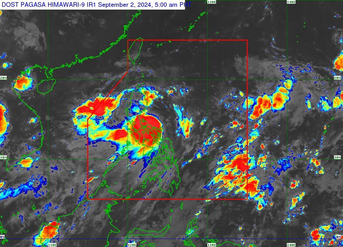
A slightly stronger and slower Tropical Storm “Enteng” (international name “Yagi”) continues to move across the coastal waters of Camarines Norte, with landfall still possible over Isabela or Cagayan on Monday afternoon or evening, Sept. 2, said the Philippine Atmospheric, Geophysical and Astronomical Services Administration (PAGASA).
In PAGASA’s 5 a.m. bulletin, Enteng has maximum sustained winds of 75 kilometers per hour (kph) near the center, with gusts reaching up to 90 kph, an increase from 65 kph maximum winds and 80 kph gusts in the previous bulletin.
Further intensification is likely over the Philippine Sea due to favorable conditions, PAGASA said.
If it maintains its west-northwestward movement at 10 kph, Enteng may make landfall in Isabela or Cagayan this afternoon or evening.
However, if the storm track shifts further west, landfall over northern Aurora cannot be ruled out, PAGASA said.
Enteng was earlier expected to make landfall over Catanduanes; however, a shift in movement has redirected its path towards the eastern parts of Central and Northern Luzon.
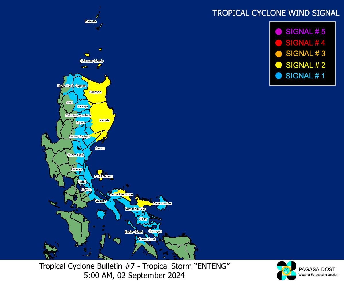
Wind warnings
Due to the anticipated strong winds from Enteng, Tropical Cyclone Wind Signal No. 2 remains hoisted over the northeastern portion of Camarines Norte, northeastern portion of Camarines Sur, eastern portion of Cagayan, including Babuyan Islands, the eastern portion of Isabela, northern portion of Aurora, Polillo Islands, the eastern portion of Quirino, and the eastern portion of Kalinga.
Meanwhile, Signal No. 1 remains in effect in the southern portion of Batanes, eastern portion of Ilocos Norte, eastern portion of Abra, Apayao, the rest of Kalinga, eastern portion of Mountain Province, eastern portion of Ifugao, the rest of Cagayan, the rest of Isabela, the rest of Quirino, eastern portion of Nueva Vizcaya, the rest of Aurora, eastern portion of Nueva Ecija, eastern portion of Bulacan, eastern portion of Rizal, eastern portion of Laguna, northern and southern portions of Quezon, Marinduque, the rest of Camarines Norte, the rest of Camarines Sur, Albay, Sorsogon, Catanduanes, and the northern portion of Masbate, including Ticao and Burias Islands.
PAGASA said the highest wind signal that may be raised during the passage of Enteng could be Signal No. 3.
Heavy rainfall
Torrential rains (more than 200 millimeters) are expected to persist in Camarines Norte, Camarines Sur, Albay, Polillo Island, and the southern portion of mainland Quezon in the next few hours.
Heavy to intense rains (100 to 200 millimeters) may also prevail over Aurora, the rest of Quezon, Catanduanes, Masbate, and Sorsogon.
Meanwhile, moderate to heavy (50 to 100 millimeters) may continue to affect Metro Manila, Isabela, Quirino, Bulacan, Cavite, Laguna, Batangas, Rizal, Marinduque, and Romblon.
The storm-enhanced southwest monsoon, or “habagat,” may also bring heavy to intense rains to Occidental Mindoro, Oriental Mindoro, northern Palawan, including Calamian, Cuyo, and Cagayancillo Islands, and Antique.
Moderate to heavy rains due to the habagat may also affect Zambales, Bataan, Tarlac, Pampanga, Nueva Ecija, the rest of Palawan, the rest of Western Visayas, and Negros Island Region.
PAGASA warned that these conditions could cause flooding and rain-induced landslides, particularly in areas identified as highly vulnerable in official hazard maps and those that have recently received heavy rainfall.