


 Philippines
National
'Enteng' moves over West Philippine Sea, but stormy conditions continue in parts of N. Luzon
Philippines
National
'Enteng' moves over West Philippine Sea, but stormy conditions continue in parts of N. Luzon
'Enteng' moves over West Philippine Sea, but stormy conditions continue in parts of N. Luzon


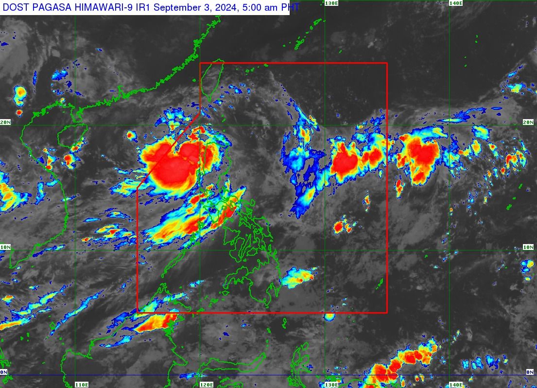
Tropical Storm “Enteng” (international name “Yagi”) accelerated while crossing northern Luzon and moved over the West Philippine Sea early Tuesday morning, Sept. 3, the Philippine Atmospheric, Geophysical and Astronomical Services Administration (PAGASA) said in its latest bulletin.
As of 5 a.m., the center of the storm was located over the coastal waters of Paoay, Ilocos Norte.
Enteng has maximum sustained winds of 75 kilometers per hour (kph) near the center and gusts reaching up to 125 kph, down from 85 kph maximum winds and 140 kph gusts in the previous bulletin.
PAGASA said the storm is expected to continue moving generally west-northwestward over the next 24 hours and turn westward over the West Philippine Sea starting on Wednesday, Sept. 4.
Based on the track forecast, Enteng may exit the Philippine Area of Responsibility by Wednesday morning.
Strong winds, heavy rainfall persist
Although the storm has exited the landmass, Enteng continues to affect parts of northern Luzon.
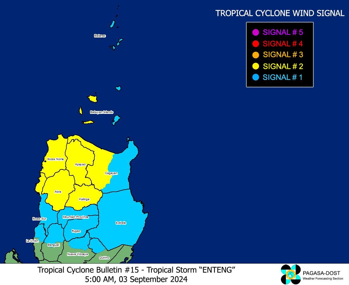
Tropical Cyclone Wind Signal No. 2 remains hoisted over Ilocos Norte, northern portion of Ilocos Sur, Apayao, Abra, Kalinga, and western portion of mainland Cagayan including Babuyan Islands.
Signal No. 1 also remains in effect for the rest of Ilocos Sur, northern portion of La Union, Mountain Province, Ifugao, northern portion of Benguet, Batanes, the rest of mainland Cagayan, the rest of Babuyan Islands, Isabela, northern portion of Nueva Vizcaya, and northern portion of Quirino.
On Tuesday, the storm is expected to bring heavy to intense rains (100 to 200 millimeters) to the Ilocos Region and moderate to heavy rains (50 to 100 millimeters) to Cagayan Valley and the Cordillera Administrative Region.
On Wednesday, rainfall is anticipated to be less intense, with moderate to heavy rains likely in Ilocos Norte.
In the next few hours, PAGASA said the southwest monsoon, or “habagat,” is also likely to cause heavy to intense rains over Zambales, Bataan, and Occidental Mindoro, and moderate to heavy rains over northern Palawan (including Calamian, Cuyo, and Cagayancillo Islands), Metro Manila, Cavite, Batangas, Rizal, Laguna, Bulacan, Pampanga, Tarlac, and Nueva Ecija.
By Wednesday, heavy to intense rains are expected over Zambales, Bataan, and Occidental Mindoro, while moderate to heavy rains are possible over northern Palawan (including Calamian, Cuyo, and Cagayancillo Islands), Metro Manila, Cavite, Batangas, Rizal, Laguna, Bulacan, Pampanga, Tarlac, Nueva Ecija, La Union, Pangasinan, and Benguet.
By Thursday, heavy to intense rains may persist in Zambales, Bataan, and Occidental Mindoro, while moderate to heavy rains may continue in northern Palawan (including Calamian, Cuyo, and Cagayancillo Islands), Metro Manila, Cavite, Batangas, Rizal, Laguna, Bulacan, Pampanga, Tarlac, Nueva Ecija, La Union, Pangasinan, and Benguet.
PAGASA warned of flooding and rain-induced landslides, particularly in areas identified as highly or very highly susceptible to these hazards and in regions that have received significant rainfall in the past few days.