


'Gener' set to exit Philippines as 'Pulasan' approaches PAR


Tropical Depression “Gener” is expected to exit the country’s area of responsibility within 24 hours, while Tropical Storm “Pulasan” may enter the region during this period, the Philippine Atmospheric, Geophysical and Astronomical Services Administration (PAGASA) said on Tuesday, Sept. 17.
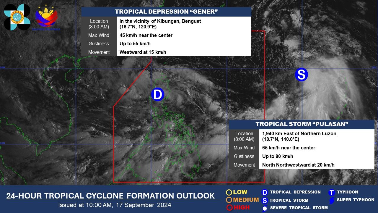
As of 11 a.m., PAGASA said Gener is about to emerge into the West Philippine Sea after crossing northern Luzon and is expected to be outside the PAR between Tuesday evening and Wednesday morning, Sept. 18.
Following its landfall in Palanan, Isabela late Monday, Sept. 16, the center of Gener was located in Kibungan, Benguet around 10 a.m. Tuesday.
Gener has slightly weakened, with maximum sustained winds of 45 kilometers per hour (kph) near the center and gusts of up to 55 kph.
As it starts to leave the landmass, Tropical Cyclone Wind Signal No. 1 has been lifted in some areas, including northern Metro Manila, but remains in effect in Cagayan, including Babuyan Islands, Isabela, Quirino, Nueva Vizcaya, Apayao, Kalinga, Abra, Ifugao, Mountain Province, Benguet, Ilocos Norte, Ilocos Sur, La Union, Pangasinan, Zambales, Tarlac, Nueva Ecija, and Pampanga.
From Tuesday to Wednesday noon, PAGASA said Gener may continue to bring heavy to intense rainfall (100 to 200 millimeters) to Cagayan, Apayao, Kalinga, Mountain Province, Ifugao, Ilocos Norte, and Abra.
In addition, moderate to heavy rainfall (50 to 100 millimeters) may affect the rest of Cordillera Administrative Region (CAR), the rest of Cagayan Valley, Ilocos Sur, La Union, Pangasinan, Nueva Ecija, Bulacan, Quezon, Rizal, and Aurora.
From Wednesday noon to Thursday noon, Sept. 19, only moderate to heavy rainfall is expected to persist in Ilocos Region, CAR, Cagayan Valley, Zambales, and Bataan.
PAGASA added that the southwest monsoon, or “habagat,” enhanced by Gener and Tropical Storm “Pulasan,” outside the Philippine Area of Responsibility (PAR), may continue to bring heavy to intense rainfall to Palawan, Occidental Mindoro, Aklan, Antique, and Negros Occidental from Tuesday to Wednesday noon.
Moderate to heavy monsoon rains may also affect Oriental Mindoro, Marinduque, Romblon, the rest of Western Visayas, the rest of Negros Island Region (NIR), Bicol Region, Zamboanga del Sur, Lanao del Norte, Lanao del Sur, Maguindanao del Norte, and Maguindanao del Sur.
From Wednesday noon to Thursday noon, heavy to intense rainfall may persist in Palawan, Occidental Mindoro, and Antique, while moderate to heavy rainfall may affect Metro Manila, Cavite, Laguna, Batangas, Rizal, Quezon, Oriental Mindoro, Marinduque, Romblon, the rest of Western Visayas, NIR, Bicol Region, and Central Visayas.
From Thursday noon to Friday noon, Sept. 20, heavy to intense rainfall may be confined to Occidental Mindoro.
Meanwhile, moderate to heavy rainfall may persist in Metro Manila, Zambales, Bataan, Cavite, Batangas, Quezon, La Union, Pangasinan, Aklan, Antique, Oriental Mindoro, Marinduque, Romblon, and Palawan.
PAGASA warned of possible flooding or landslides, especially in areas classified as “highly or very highly susceptible” to these hazards and areas that have received substantial rainfall in the past few days.
‘Pulasan’ approaches PAR
At the same time that Gener is expected to exit the PAR, Tropical Storm Pulasan may enter the region between Tuesday evening and Wednesday morning.
PAGASA Weather Specialist Veronica Torres said that as of 11 a.m., Pulasan was located 1,800 kilometers east of extreme northern Luzon.
It has maximum sustained winds of 65 kph and gusts of up to 80 kph and is expected to move north-northwestward at 25 kph.
Once it enters the PAR, it will be given the local name “Helen.”
However, Torres said the storm is expected to stay within the PAR briefly, possibly exiting by Wednesday afternoon or evening.
Although it may remain far from the country’s landmass, the weather disturbance could continue to enhance the effects of the habagat, which could bring rains across the western parts of the country.