ADVERTISEMENT

Tropical depression outside PAR intensifies into storm; will enhance 'habagat'

Published Sep 16, 2024 12:08 am

At A Glance

  • Once it enters the PAR, the storm will be given the local name "Helen."
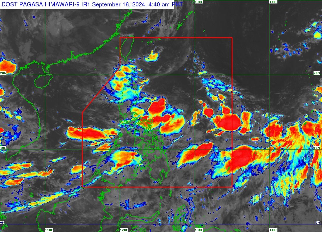
  • Regardless of whether it enters or not, the storm may still enhance the effects of the southwest monsoon, or "habagat," in the coming days, resulting in continued rainfall, especially in Mimaropa, Bicol Region, Visayas, and parts of Calabarzon.
IMG_4267.jpeg
Satellite image of Tropical Storm “Pulasan” (PAGASA)

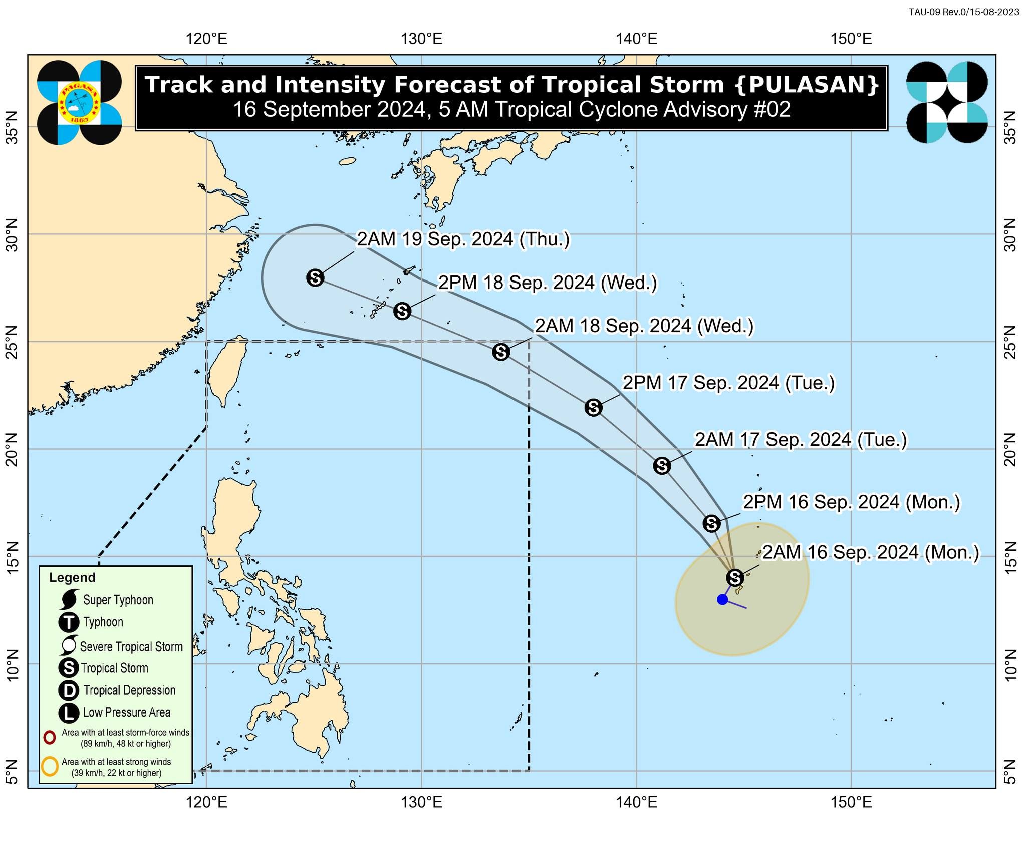
The tropical depression monitored outside the country’s area of responsibility intensified into a tropical storm on Monday, Sept, 16, and was given the international name “Pulasan.”

Pulasan, which is a type of fruit, is a name contributed by Malaysia, said Philippine Atmospheric, Geophysical and Astronomical Services Administration (PAGASA) Weather Specialist Obet Badrina.

As of 4 a.m., the storm was located 2,215 km east of southeastern Luzon, with maximum sustained winds of 65 kilometers per hour (kph) near the center and gusts of up to 80 kph.

Badrina said Pulasan is expected to move north-northeastward at 20 kph and enter the Philippine Area of Responsibility (PAR) by Tuesday, Sept. 17.

Once it enters the PAR, the storm will be given the local name “Helen.”

However, Badrina noted that the weather disturbance may only graze the northern boundary of the PAR before exiting by Wednesday, Sept. 18. There is also a possibility that it may not enter the vicinity at all.

IMG_4268.jpeg
Tropical Storm Pulasan’s projected track and intensity (PAGASA)

Regardless of whether it enters or not, he said the storm may still enhance the effects of the southwest monsoon, or “habagat,” in the coming days, resulting in continued rainfall, especially in Mimaropa, Bicol Region, Visayas, and parts of Calabarzon.

He added that there is also a chance of rain in Metro Manila.

PAGASA said Pulasan is expected to move generally north-northeastward over the next 12 hours before shifting to a northwestward track from Monday afternoon through Wednesday afternoon, Sept. 18.

Following this period, the storm is expected to continue on a west-northwestward track for the remainder of the forecast period.

PAGASA said it is expected to remain a tropical storm throughout this time.

However, the possibility of further intensification cannot be ruled out, as the weather disturbance is still over the Pacific Ocean.

Given its current track, similar to that of tropical storm “Ferdie” (Bebinca), Pulasan is not expected to have a direct impact on any part of the country during the forecast period, PAGASA said.

Related Tags

PAGASA Habagat Tropical Storm Pulasan
ADVERTISEMENT
.most-popular .layout-ratio{ padding-bottom: 79.13%; } @media (min-width: 768px) and (max-width: 1024px) { .widget-title { font-size: 15px !important; } }

{{ articles_filter_1561_widget.title }}

.most-popular .layout-ratio{ padding-bottom: 79.13%; } @media (min-width: 768px) and (max-width: 1024px) { .widget-title { font-size: 15px !important; } }

{{ articles_filter_1562_widget.title }}

.most-popular .layout-ratio{ padding-bottom: 79.13%; } @media (min-width: 768px) and (max-width: 1024px) { .widget-title { font-size: 15px !important; } }

{{ articles_filter_1563_widget.title }}

{{ articles_filter_1564_widget.title }}

.mb-article-details { position: relative; } .mb-article-details .article-body-preview, .mb-article-details .article-body-summary{ font-size: 17px; line-height: 30px; font-family: "Libre Caslon Text", serif; color: #000; } .mb-article-details .article-body-preview iframe , .mb-article-details .article-body-summary iframe{ width: 100%; margin: auto; } .read-more-background { background: linear-gradient(180deg, color(display-p3 1.000 1.000 1.000 / 0) 13.75%, color(display-p3 1.000 1.000 1.000 / 0.8) 30.79%, color(display-p3 1.000 1.000 1.000) 72.5%); position: absolute; height: 200px; width: 100%; bottom: 0; display: flex; justify-content: center; align-items: center; padding: 0; } .read-more-background a{ color: #000; } .read-more-btn { padding: 17px 45px; font-family: Inter; font-weight: 700; font-size: 18px; line-height: 16px; text-align: center; vertical-align: middle; border: 1px solid black; background-color: white; } .hidden { display: none; }
function initializeAllSwipers() { // Get all hidden inputs with cms_article_id document.querySelectorAll('[id^="cms_article_id_"]').forEach(function (input) { const cmsArticleId = input.value; const articleSelector = '#article-' + cmsArticleId + ' .body_images'; const swiperElement = document.querySelector(articleSelector); if (swiperElement && !swiperElement.classList.contains('swiper-initialized')) { new Swiper(articleSelector, { loop: true, pagination: false, navigation: { nextEl: '#article-' + cmsArticleId + ' .swiper-button-next', prevEl: '#article-' + cmsArticleId + ' .swiper-button-prev', }, }); } }); } setTimeout(initializeAllSwipers, 3000); const intersectionObserver = new IntersectionObserver( (entries) => { entries.forEach((entry) => { if (entry.isIntersecting) { const newUrl = entry.target.getAttribute("data-url"); if (newUrl) { history.pushState(null, null, newUrl); let article = entry.target; // Extract metadata const author = article.querySelector('.author-section').textContent.replace('By', '').trim(); const section = article.querySelector('.section-info ').textContent.replace(' ', ' '); const title = article.querySelector('.article-title h1').textContent; // Parse URL for Chartbeat path format const parsedUrl = new URL(newUrl, window.location.origin); const cleanUrl = parsedUrl.host + parsedUrl.pathname; // Update Chartbeat configuration if (typeof window._sf_async_config !== 'undefined') { window._sf_async_config.path = cleanUrl; window._sf_async_config.sections = section; window._sf_async_config.authors = author; } // Track virtual page view with Chartbeat if (typeof pSUPERFLY !== 'undefined' && typeof pSUPERFLY.virtualPage === 'function') { try { pSUPERFLY.virtualPage({ path: cleanUrl, title: title, sections: section, authors: author }); } catch (error) { console.error('ping error', error); } } // Optional: Update document title if (title && title !== document.title) { document.title = title; } } } }); }, { threshold: 0.1 } ); function showArticleBody(button) { const article = button.closest("article"); const summary = article.querySelector(".article-body-summary"); const body = article.querySelector(".article-body-preview"); const readMoreSection = article.querySelector(".read-more-background"); // Hide summary and read-more section summary.style.display = "none"; readMoreSection.style.display = "none"; // Show the full article body body.classList.remove("hidden"); } document.addEventListener("DOMContentLoaded", () => { let loadCount = 0; // Track how many times articles are loaded const offset = [1, 2, 3, 4, 5, 6, 7, 8, 9, 10]; // Offset values const currentUrl = window.location.pathname.substring(1); let isLoading = false; // Prevent multiple calls if (!currentUrl) { console.log("Current URL is invalid."); return; } const sentinel = document.getElementById("load-more-sentinel"); if (!sentinel) { console.log("Sentinel element not found."); return; } function isSentinelVisible() { const rect = sentinel.getBoundingClientRect(); return ( rect.top < window.innerHeight && rect.bottom >= 0 ); } function onScroll() { if (isLoading) return; if (isSentinelVisible()) { if (loadCount >= offset.length) { console.log("Maximum load attempts reached."); window.removeEventListener("scroll", onScroll); return; } isLoading = true; const currentOffset = offset[loadCount]; window.loadMoreItems().then(() => { let article = document.querySelector('#widget_1690 > div:nth-last-of-type(2) article'); intersectionObserver.observe(article) loadCount++; }).catch(error => { console.error("Error loading more items:", error); }).finally(() => { isLoading = false; }); } } window.addEventListener("scroll", onScroll); });

Sign up by email to receive news.