


Signal No. 1 up over 19 Luzon areas due to TD Gener


At A Glance
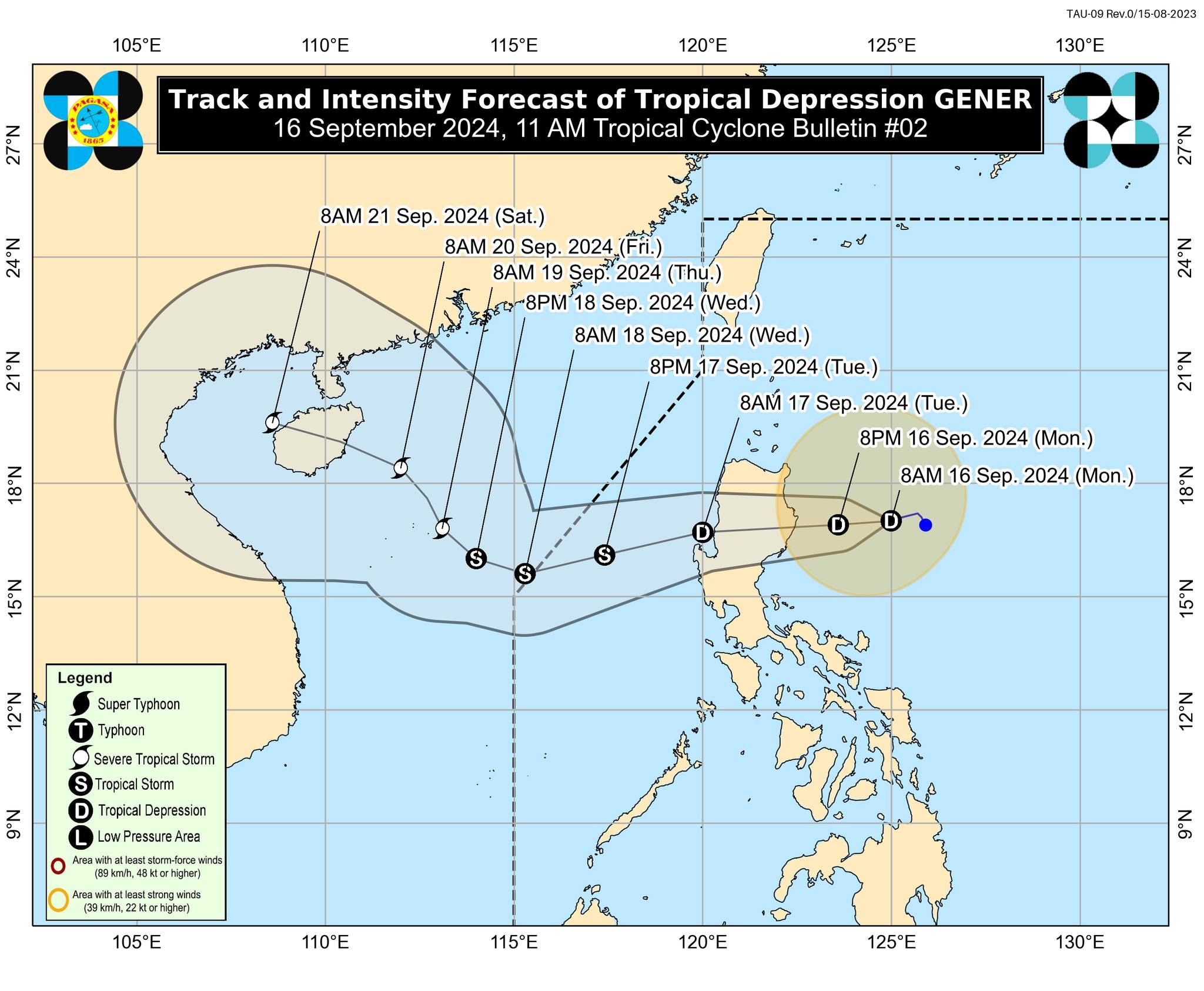
- Tropical Depression Gener is projected to move west-southwestward slowly and make landfall over Isabela or Aurora within 24 hours.
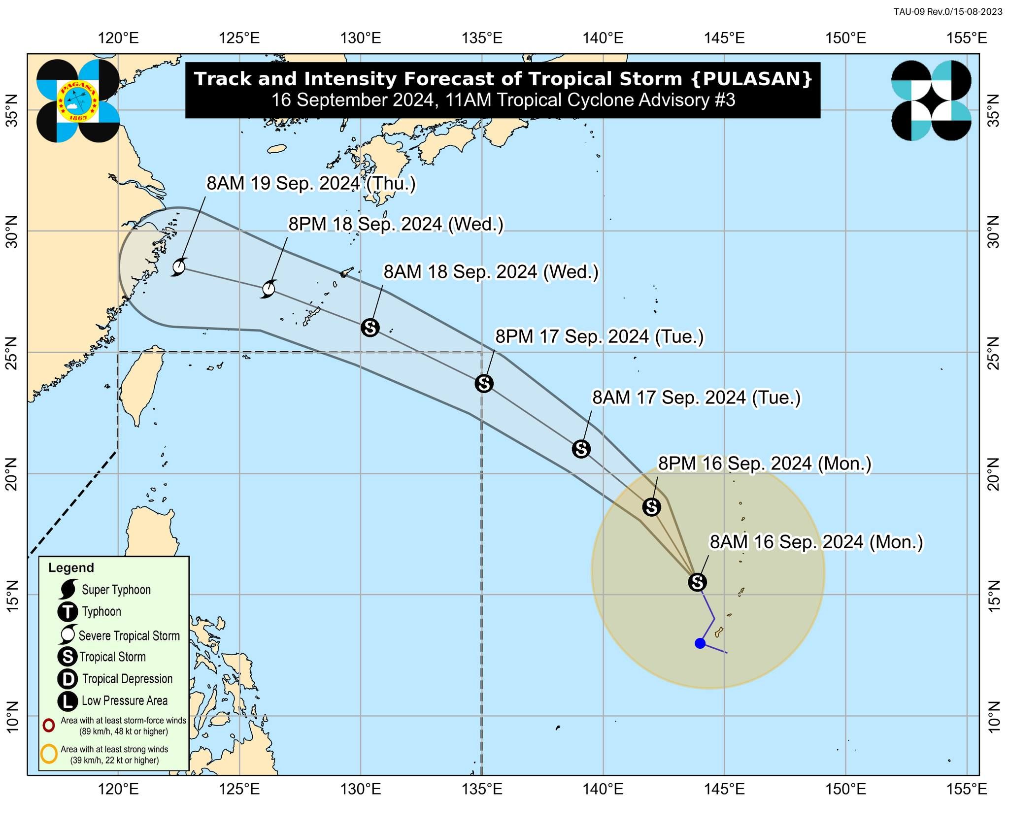
- PAGASA is also continuously monitoring a tropical storm outside the PAR with the international name "Pulasan."
- Pulasan may also enter the PAR on Tuesday, Sept. 17., and will be given the local name "Helen."
Tropical Cyclone Wind Signal No. 1 was raised in 19 areas in Luzon on Monday, Sept. 16, as Tropical Depression “Gener” nears landfall, the Philippine Atmospheric, Geophysical and Astronomical Services Administration (PAGASA) said in its latest advisory.
As of 11 a.m., Signal No. 1 was hoisted over Cagayan, including Babuyan Islands, Isabela, Quirino, Nueva Vizcaya, Apayao, Kalinga, Abra, Ifugao, Mountain Province, Benguet, Ilocos Norte, Ilocos Sur, La Union, Pangasinan, Zambales, Tarlac, Nueva Ecija, Aurora, and the northern portion of Quezon, including Polillo Islands.
PAGASA said Gener has slightly intensified with maximum sustained winds of 55 kilometers per hour (kph) near the center and gusts of up to 70 kph.
It is projected to move west-southwestward slowly and make landfall over Isabela or Aurora within 24 hours.
Rainfall forecast
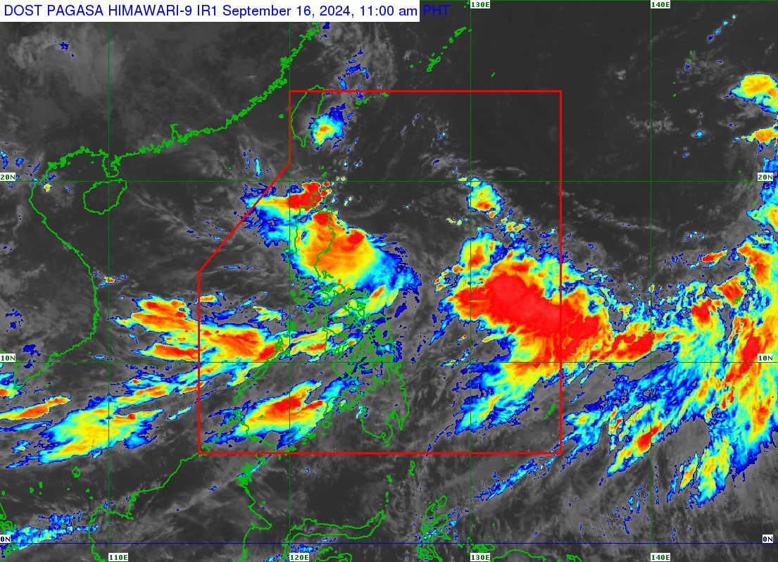
PAGASA warned of heavy rains in several areas in Luzon, as well as parts of Visayas, due to the combined effects of Tropical Depression Gener and the enhanced southwest monsoon, or “habagat.”
From Monday noon to Tuesday noon, Sept. 17, heavy to intense rains (100 to 200 millimeters) may affect Palawan, Occidental Mindoro, Aklan, Antique, Negros Occidental, Cagayan, Isabela, Quirino, and Aurora.
Moderate to heavy rains (50 to 100 millimeters) may also affect Oriental Mindoro, Marinduque, Romblon, the rest of Western Visayas, the rest of Negros Island Region (NIR), Quezon, Camarines Norte, Camarines Sur, the rest of Cagayan Valley, the rest of Cordillera Administrative Region (CAR), Ilocos Norte, Nueva Ecija, and Bulacan.
From Tuesday noon to Wednesday noon, Sept. 18, heavy to intense rainfall may prevail over Palawan, Occidental Mindoro, Aklan, Antique, Negros Occidental, Cagayan, Isabela, Apayao, Mountain Province, Kalinga, Ifugao, Aurora, and Polillo Islands.
Meanwhile, moderate to heavy rains may be experienced in Metro Manila, Cavite, Laguna, Batangas, Rizal, Quezon, Oriental Mindoro, Marinduque, Romblon, the rest of Western Visayas, the rest of NIR, Central Visayas, Ilocos Region, the rest of Cagayan Valley, the rest of CAR, and the rest of Central Luzon.
From Wednesday noon to Thursday noon, Sept. 19, heavy to intense rainfall may continue in Occidental Mindoro.
Moderate to heavy rains may persist in Metro Manila, Zambales, Bataan, Aklan, Antique, Oriental Mindoro, Marinduque, Romblon, Palawan, Cagayan, including Babuyan Islands, Isabela, and Apayao.
PAGASA warned of possible flooding or landslides, especially in areas classified as “highly or very highly susceptible” to these hazards and areas that have received substantial rainfall in the past few days.
After its landfall, tropical Depression Gener is projected to emerge over the coastal waters of La Union or Pangasinan on Tuesday morning.
It will then cross Luzon before heading west-southwestward over the West Philippine Sea on Tuesday.
By Wednesday, Gener is expected to turn generally northwestward and may exit the Philippine Area of Responsibility (PAR) between late Tuesday evening and Wednesday morning.
Storm ‘Pulasan’
PAGASA is also continuously monitoring a tropical storm outside the PAR with the international name “Pulasan.”
Pulasan, a type of fruit, is a name contributed by Malaysia.
As of 10 a.m., the storm was located 2,045 kilometers east of southeastern Luzon and is projected to move north-northwestward at 40 kph.
It has maximum sustained winds of 65 kph near the center and gusts of up to 80 kph.
PAGASA said Pulasan may enter the PAR on Tuesday and exit the following day, following a track similar to Tropical Storm “Ferdie” (Bebinca).
Once it enters the PAR, it will be given the local name “Helen.”
While landfall is unlikely, the storm may still enhance the effects of the habagat in the coming days, resulting in continued rainfall, especially in Mimaropa, Bicol Region, Visayas, and parts of Calabarzon.