


 Philippines
National
PAGASA: 'Bebinca'-enhanced 'habagat' rains to last 3–4 days; potential cyclone could extend downpours by up to 3 days
Philippines
National
PAGASA: 'Bebinca'-enhanced 'habagat' rains to last 3–4 days; potential cyclone could extend downpours by up to 3 days
PAGASA: 'Bebinca'-enhanced 'habagat' rains to last 3–4 days; potential cyclone could extend downpours by up to 3 days


At A Glance
- The enhanced habagat could bring significant rainfall and trigger flooding or landslides.
- In addition to Tropical Storm Bebinca, there is a possibility that two new Low Pressure Areas (LPAs) may form in the coming days—one to the east of Luzon and another in the West Philippine Sea.
- Due to possible new weather disturbances, rainfall could last five to six days instead of the initially expected three to four days.
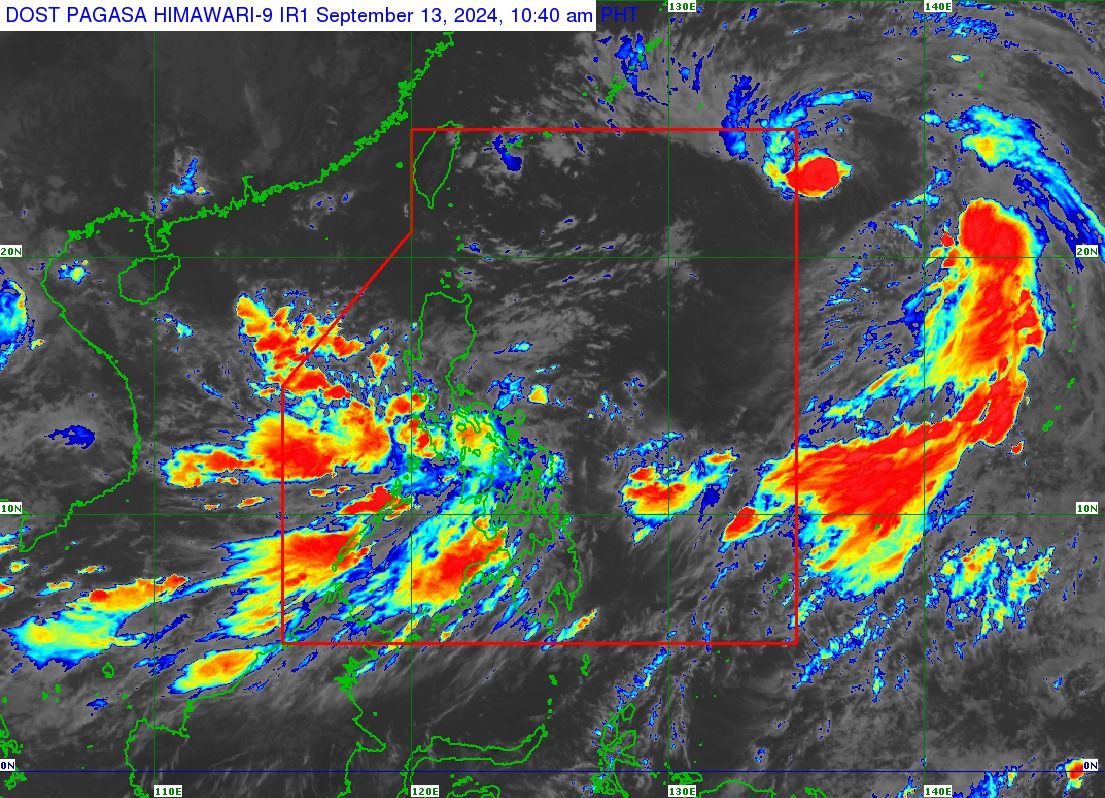
The Philippine Atmospheric, Geophysical and Astronomical Services Administration (PAGASA) on Friday, Sept. 13 warned that the southwest monsoon (habagat), enhanced by Tropical Storm “Bebinca,” will bring rains over the next three to four days, but a potential cyclone could extend the precipitation by up to three days.
In a press conference on Friday, Senior Weather Specialist Glaiza Escullar pointed out that while Bebinca has weakened on Friday morning and is expected to remain within the Philippine Area of Responsibility (PAR) only briefly, its influence on the southwest monsoon will be substantial, which will particularly affect Southern Luzon, Bicol Region, Visayas, and Mindanao.
Escullar warned that the enhanced habagat could bring significant rainfall and trigger flooding or landslides in several areas.
Heavy rainfall
On Friday, heavy to intense rains (100 to 200 millimeters) may prevail over Oriental Mindoro, Occidental Mindoro, Marinduque, Romblon, Palawan, Western Visayas, Sorsogon, Masbate, and Negros Occidental.
Meanwhile, Metro Manila, Zambales, Bataan, Cavite, Laguna, Batangas, Rizal, Quezon, the rest of Bicol Region, the rest of Visayas, Misamis Occidental, Zamboanga del Norte, Lanao del Norte, Lanao del Sur, Maguindanao, Sultan Kudarat, and Sarangani may receive 50 to 100 millimeters of rainfall (moderate to heavy).
By Saturday, Sept. 14, heavy to intense rains may persist in Oriental Mindoro, Occidental Mindoro, Marinduque, Romblon, Palawan, Aklan, and Antique.
Moderate to heavy rains may also continue in Bicol Region, Negros Island Region, and the rest of Western Visayas.
By Sunday, Sept. 15, Occidental Mindoro, northern Palawan, Aklan, and Antique may continue to experience heavy to intense rainfall.
Southern Quezon, Oriental Mindoro, Marinduque, Romblon, the rest of Palawan, Camarines Sur, Catanduanes, Albay, Sorsogon, Masbate, Negros Occidental, and the rest of Western Visayas may also receive moderate to heavy rains.
PAGASA warned of possible flooding or landslides, especially in areas classified as “highly or very highly susceptible” to these hazards and areas that have received substantial rainfall in the past few days.
Forecast track, intensity
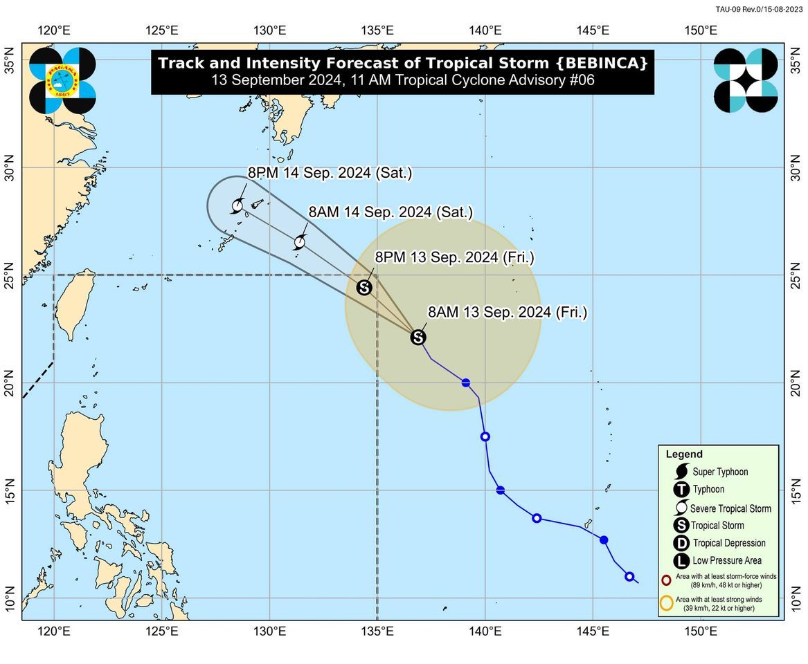
As of 10 a.m. on Friday, PAGASA said the center of the tropical storm was located 1,500 kilometers east of extreme northern Luzon.
The storm is expected to move north-northwestward at 20 kph, enter the Philippine Area of Responsibility (PAR) Friday afternoon or evening, and exit the vicinity late evening or early Saturday morning.
Bebinca will be given the local name “Ferdie” once it enters the PAR.
However, PAGASA said the weather disturbance will remain far from the country’s landmass, making landfall unlikely.
Moreover, PAGASA said Bebinca has weakened from a severe tropical storm to a tropical storm but is expected to continue to enhance the effects of the habagat, which could bring significant rainfall to parts of the country.
Bebinca has maximum sustained winds of 85 kilometers per hour (kph) near the center and gusts of up to 105 kph, down from 95 kph maximum winds and 115 kph gusts six hours ago.
In the near term, Bebinca is expected to remain a tropical storm, with further weakening not ruled out.
However, it may re-intensify into a severe tropical storm on Saturday and possibly reach typhoon category over the East China Sea.
Potential weather disturbances
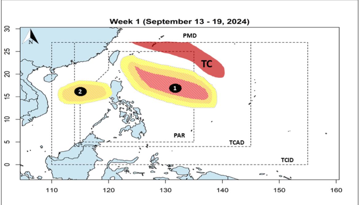
In addition to Bebinca, Escullar said there is a possibility that two new Low Pressure Areas (LPAs) may form in the coming days—one to the east of Luzon and another in the West Philippine Sea.
Escullar pointed out that if a new LPA forms to the east of the Philippines, rainfall could last five to six days instead of the initially expected three to four days, even as Bebinca continues to move away.
This LPA has a high chance of developing into a tropical cyclone and, once it does within the PAR, will be given the local name “Gener.”
Escullar said continuous rains are expected, particularly in the western parts of Southern Luzon, Visayas, and Mindanao due to this new weather disturbance.
Citing that the highest rainfall amounts recorded in the past 24 hours were in Mimaropa and Bicol Region, PAGASA Administrator Nathaniel Servando warned that prolonged periods of rain increase the risk of landslides, as well as flooding.
He added that even moderate rainfall poses a significant risk due to the already critical levels reached by recent precipitation.