


 Philippines
National
'Bebinca' likely to intensify into typhoon; another cyclone could develop early next week
Philippines
National
'Bebinca' likely to intensify into typhoon; another cyclone could develop early next week
'Bebinca' likely to intensify into typhoon; another cyclone could develop early next week


At A Glance
- Severe Tropical Storm Bebinca will enhance the effects of the southwest monsoon, or "habagat," which will bring heavy rains to parts of the country over the next few days.
- The enhancement of the habagat may continue through next week due to the potential formation of a new Low Pressure Area (LPA) east of Luzon.
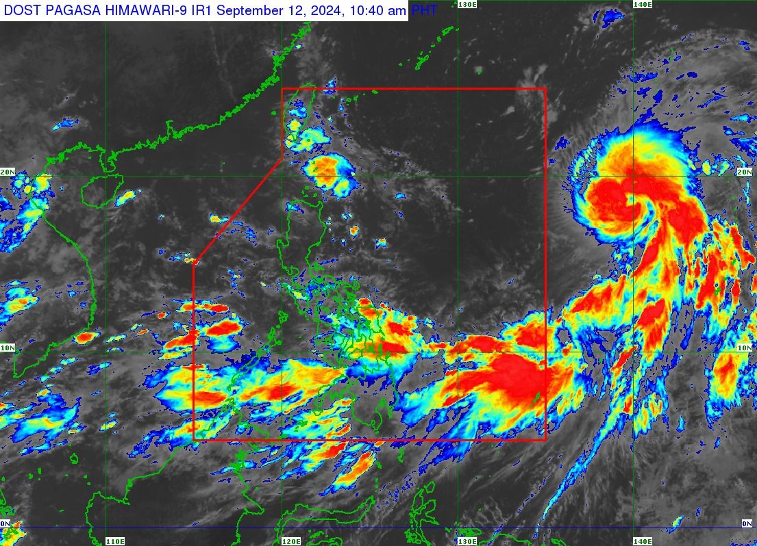
The Philippine Atmospheric, Geophysical and Astronomical Services Administration (PAGASA) said Severe Tropical Storm “Bebinca” (international name) is expected to enter the country’s area of responsibility as a typhoon on Friday, Sept. 13.
Meanwhile, as Bebinca has yet to enter the Philippine Area of Responsibility (PAR), another tropical cyclone is seen to develop by early next week, PAGASA Weather Specialist Benison Estareja said on Thursday, Sept. 12.
The next names to be assigned to tropical cyclones within the PAR will be “Ferdie” and “Gener.”
As of 11 a.m. on Thursday, the center of Bebinca was located 1,975 kilometers (km) east of Central Luzon or 1,930 km east of Northern Luzon.
It has maintained its maximum sustained winds of 95 kilometers per hour (kph) near the center and gusts of up to 115 kph while moving northward over the Philippine Sea.

Projected track, intensity
Estareja said Bebinca is anticipated to strengthen further as it moves across the Philippine Sea and is likely to become a typhoon before it enters the PAR.
“Bebinca is forecast to turn generally north-northwestward tonight (Sept. 12), then northwestward tomorrow (Sept. 13), then west-northwestward on Saturday (Sept. 14). On the track forecast, Bebinca will enter the PAR region tomorrow afternoon or evening and exit the PAR region tomorrow late evening or Saturday morning,” PAGASA said.
Throughout the forecast period, Bebinca will remain far from the Philippine landmass.
Rains due to Bebinca’s trough
Over the next 24 hours, PAGASA said the trough or outer cloud bands of Bebinca may bring cloudy skies with scattered rains and thunderstorms to Eastern Visayas, Caraga, Catanduanes, Albay, Sorsogon, and Masbate.
Partly cloudy to cloudy skies with isolated rain showers or thunderstorms may also affect Cagayan Valley, Aurora, Quezon, and the rest of Bicol Region.
Meanwhile, the rest of the country, including Metro Manila, will have partly cloudy to cloudy skies with isolated rain showers due to localized thunderstorms.
Estareja said thunderstorms may become more frequent as the habagat intensifies.
‘Habagat’ rains
While Bebinca may not make landfall, Estareja warned that it will enhance the effects of the southwest monsoon, or “habagat,” which will bring heavy rains to parts of the country over the next few days.
By Friday, Sept. 13, Occidental Mindoro, Palawan, Antique, and Negros Occidental may receive 100 to 200 millimeters of rainfall (heavy to intense).
Meanwhile, Cavite, Batangas, Oriental Mindoro, Marinduque, Romblon, Masbate, Sorsogon, the rest of Visayas, Zamboanga Peninsula, Misamis Occidental, Lanao del Norte, and Lanao del Sur may receive 50 to 100 millimeters of rainfall (moderate to heavy).
By Saturday, Sept. 14, heavy to intense rainfall may persist in Occidental Mindoro, Palawan, and Antique.
Meanwhile, heavy to intense rains may continue in Cavite, Batangas, Oriental Mindoro, Marinduque, Romblon, Masbate, Sorsogon, the rest of Visayas, and Negros Island Region.
PAGASA warned of possible flooding or landslides, particularly in areas identified as "highly or very highly susceptible" to these hazards and areas that have received significant rainfall in the past few days.
Potential cyclone
Estareja said the enhancement of the habagat may continue through next week due to the potential formation of a new Low Pressure Area (LPA) east of Luzon.
He added there is a high chance the LPA could develop into a tropical cyclone by early next week but the likelihood of landfall remains low, as it is expected to move northwestward.
However, Estareja pointed out that tropical cyclones in the northern Philippine Sea tend to intensify the effects of the habagat. This may lead to rainy conditions across several areas of the country next week.