


 Philippines
National
'Enteng' may make landfall over Catanduanes or Albay, says PAGASA
Philippines
National
'Enteng' may make landfall over Catanduanes or Albay, says PAGASA
'Enteng' may make landfall over Catanduanes or Albay, says PAGASA


At A Glance
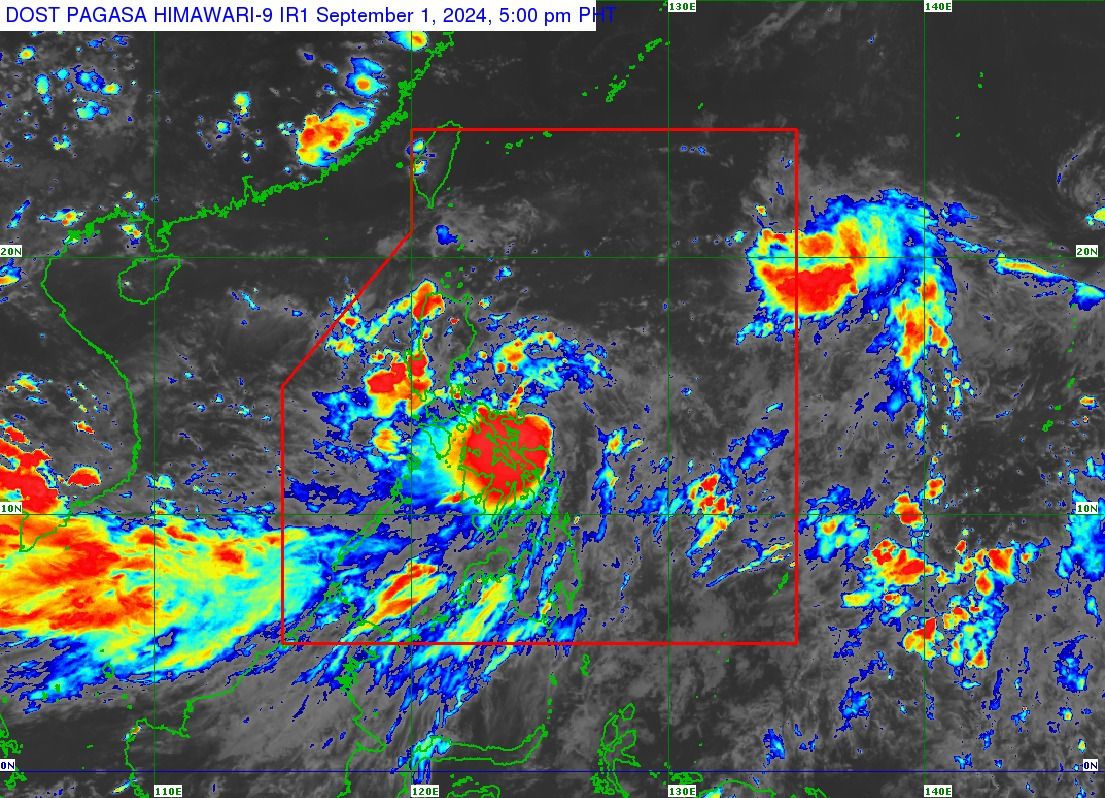
- The center of Tropical Depression Enteng was located 110 kilometers east-northeast of Catarman, Northern Samar as of 5 p.m. on Sunday, Sept. 1.
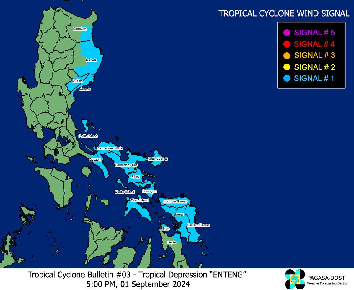
- Signal No. 1 was raised over the southeastern portion of Cagayan, eastern portion of Isabela, southern portion of Quirino, northern portion of Aurora, Polillo Islands, southern portion of mainland Quezon, Camarines Norte, Camarines Sur, Catanduanes, Albay, Sorsogon, Masbate incuding Ticao and Burias Islands, Northern Samar, Samar, Eastern Samar, Biliran, and the northeastern portion of Leyte.
- Heavy rainfall warnings were issued in several areas in Luzon and Visayas due to the tropical depression and the enhanced southwest monsoon, or "habagat."
There is now a high chance that Tropical Depression “Enteng” may make landfall over Catanduanes or Albay within the next 12 hours, the Philippine Atmospheric, Geophysical and Astronomical Services Administration (PAGASA) said on Sunday afternoon, Sept. 1.
In PAGASA’s bulletin issued at 5 p.m., the center of Enteng was located 110 kilometers east-northeast of Catarman, Northern Samar.
The tropical depression has slightly intensified, with maximum sustained winds of 55 kilometers per hour (kph) near the center and gusts of up to 70 kph, up from 45 kph maximum winds and 55 kph gusts in the previous bulletin.
It is currently moving westward at 15 kph.
PAGASA said Enteng is likely begin moving northwestward by early Monday morning, Sept. 2, before making landfall over Catanduanes or Albay within the next 12 hours.
Signals 2, 3 likely
Due to the anticipated approach of Tropical Depression Enteng, Wind Signal No. 1 was raised over the southeastern portion of Cagayan, eastern portion of Isabela, southern portion of Quirino, northern portion of Aurora, Polillo Islands, southern portion of mainland Quezon, Camarines Norte, Camarines Sur, Catanduanes, Albay, Sorsogon, Masbate incuding Ticao and Burias Islands, Northern Samar, Samar, Eastern Samar, Biliran, and the northeastern portion of Leyte.
PAGASA said the highest wind signals that may be raised during the passage of Enteng could be Signal No. 2 or 3.
Heavy rainfall warnings were also issued in several areas in Luzon and Visayas due to the tropical depression and the enhanced southwest monsoon, or “habagat.”
From Sunday to Monday, heavy to intense rains (100-200 millimeters) are expected in Polillo Islands, Catanduanes, Camarines Norte, Camarines Sur, Masbate, Albay, Sorsogon, Northern Samar, and Samar.
Moderate to heavy rains (50-100 millimeters) may affect Metro Manila, the rest of Quezon province, Cavite, Laguna, Batangas, Rizal, Marinduque, Romblon, Eastern Samar, Biliran, and the northern portion of Leyte.
From Monday to Tuesday, Sept. 3, heavy to intense rains may impact Isabela, Cagayan, Abra, and Ilocos Norte.
Meanwhile, moderate to heavy rains may be experienced in Aurora, Ilocos Sur, La Union, Pangasinan, Cordillera Administrative Region, and mainland Cagayan Valley.
From Tuesday to Wednesday, Sept. 4, heavy to intense rains may occur in Babuyan Islands, Apayao, Ilocos Norte, and the northern portion of Ilocos Sur, while moderate to heavy rains may persist in Batanes, mainland Cagayan, and the rest of Cordillera Administrative Region and Ilocos Region.
PAGASA warned that these conditions could lead to flooding and rain-induced landslides, particularly in areas highly susceptible to such hazards as identified in official hazard maps and locations with recent heavy rainfall.
Another landfall still possible
On Monday, PAGASA said Enteng will turn more north-northwestward or northward after moving over the waters north of Camarines Norte and Camarines Sur, and will continue over the waters east of Luzon.
From Tuesday to Wednesday, Enteng is expected to initially turn northwestward, then westward, while slowing down over the Luzon Strait.
PAGASA said another landfall in mainland Northern Luzon or Babuyan Islands is not ruled out.
A more northwestward movement is expected from Thursday, Sept. 5.
PAGASA said Enteng could reach tropical storm strength within the next 12 hours and maintain this intensity until early Wednesday.
It may reach typhoon strength by Thursday or Friday, Sept. 6.