ADVERTISEMENT

'Carina' weakens into typhoon as it nears Taiwan

Published Jul 24, 2024 03:42 pm
IMG_4040.jpeg
Satellite image of Typhoon Carina (international name: Gaemi) (PAGASA/Facebook)

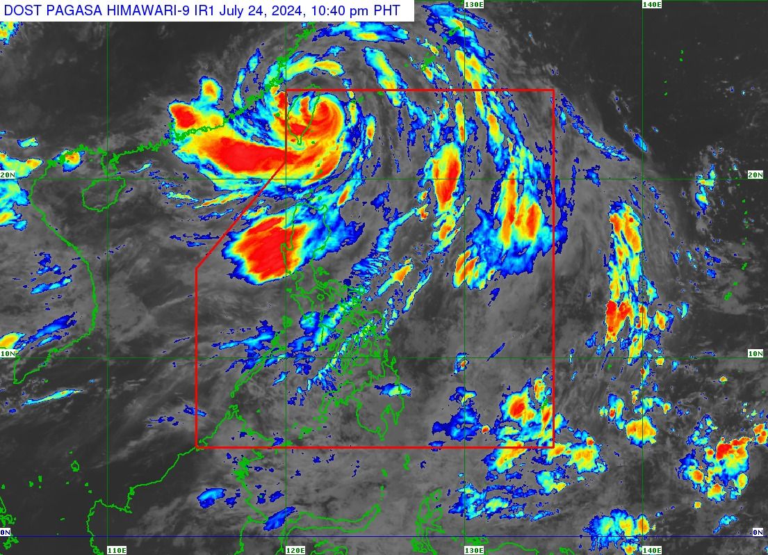
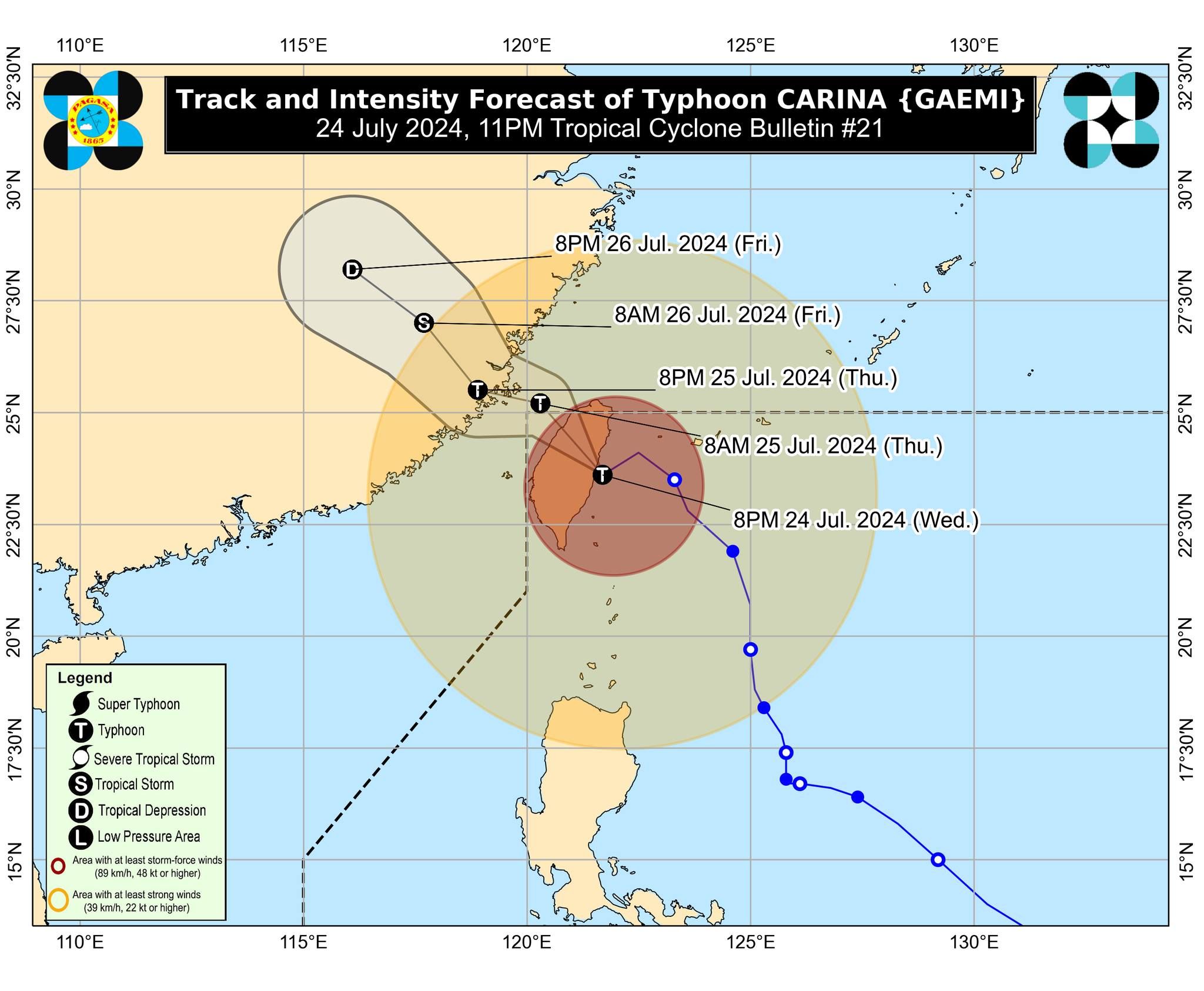
Super typhoon “Carina” (international name “Gaemi”) weakened to a typhoon after making a looping track before making landfall over Taiwan, the Philippine Atmospheric, Geophysical and Astronomical Services Administration (PAGASA) said in its 11 p.m. bulletin on Wednesday, July 24.

PAGASA said Carina currently has maximum sustained winds of 175 kilometers per hour (kph) near the center and gusts of up to 215 kph, down from the previously recorded maximum winds of 185 kph and gusts of 230 kph recorded six hours ago.

The typhoon was located 335 kilometers north of Itbayat, Batanes, moving westward at 15 kph.

PAGASA said Carina is expected to make landfall in Taiwan between Wednesday evening and early Thursday morning, July 25, before exiting the Philippine area of responsibility (PAR).

“Due to its prolonged interaction with the mountainous terrain of Taiwan over the past several hours, Carina has started to weaken to a typhoon,” PAGASA said.

“Typhoon Carina is now less likely to directly bring heavy rainfall over any portion of the country,” it added.

However, Tropical Cyclone Wind Signal No. 2 remains hoisted over Batanes, while Signal No. 1 is still in effect over Babuyan Islands, the northern portion of mainland Cagayan (Claveria, Santa Praxedes, Sanchez-Mira, Pamplona, Abulug, Ballesteros, Aparri, Camalaniugan, Buguey, Santa Teresita, Santa Ana, Gonzaga), and the northern portion of Ilocos Norte (Burgos, Bangui, Pagudpud, Dumalneg, Adams).

IMG_4041.jpeg
Typhoon Carina’s track and intensity outlook (PAGASA/Facebook)

PAGASA said the southwest monsoon, or “habagat,” enhanced by typhoon Carina, may continue to bring moderate to intense rains over parts of western Luzon until Saturday, July 27.

Heavy to intense monsoon rains may persist in Zambales, La Union, Pangasinan, and Benguet, while moderate to heavy rains are likely over Metro Manila, Bulacan, Pampanga, Cavite, Batanes, Babuyan Islands, the rest of Ilocos Region, Abra, Bataan, and Occidental Mindoro.

By Friday, July 26, moderate to heavy rains due to habagat may affect Zambales, Bataan, Pangasinan, and Benguet.

On Saturday, Zambales and Bataan may continue to experience moderate to heavy rains.

“Under these conditions, flooding and rain-induced landslides are possible, especially in areas that are highly or very highly susceptible to these hazards as identified in official hazard maps and in localities that experienced considerable amounts of rainfall for the past several days,” PAGASA warned.

Related Tags

signal no. 2 PAGASA Habagat Super Typhoon Carina
ADVERTISEMENT
.most-popular .layout-ratio{ padding-bottom: 79.13%; } @media (min-width: 768px) and (max-width: 1024px) { .widget-title { font-size: 15px !important; } }

{{ articles_filter_1561_widget.title }}

.most-popular .layout-ratio{ padding-bottom: 79.13%; } @media (min-width: 768px) and (max-width: 1024px) { .widget-title { font-size: 15px !important; } }

{{ articles_filter_1562_widget.title }}

.most-popular .layout-ratio{ padding-bottom: 79.13%; } @media (min-width: 768px) and (max-width: 1024px) { .widget-title { font-size: 15px !important; } }

{{ articles_filter_1563_widget.title }}

{{ articles_filter_1564_widget.title }}

.mb-article-details { position: relative; } .mb-article-details .article-body-preview, .mb-article-details .article-body-summary{ font-size: 17px; line-height: 30px; font-family: "Libre Caslon Text", serif; color: #000; } .mb-article-details .article-body-preview iframe , .mb-article-details .article-body-summary iframe{ width: 100%; margin: auto; } .read-more-background { background: linear-gradient(180deg, color(display-p3 1.000 1.000 1.000 / 0) 13.75%, color(display-p3 1.000 1.000 1.000 / 0.8) 30.79%, color(display-p3 1.000 1.000 1.000) 72.5%); position: absolute; height: 200px; width: 100%; bottom: 0; display: flex; justify-content: center; align-items: center; padding: 0; } .read-more-background a{ color: #000; } .read-more-btn { padding: 17px 45px; font-family: Inter; font-weight: 700; font-size: 18px; line-height: 16px; text-align: center; vertical-align: middle; border: 1px solid black; background-color: white; } .hidden { display: none; }
function initializeAllSwipers() { // Get all hidden inputs with cms_article_id document.querySelectorAll('[id^="cms_article_id_"]').forEach(function (input) { const cmsArticleId = input.value; const articleSelector = '#article-' + cmsArticleId + ' .body_images'; const swiperElement = document.querySelector(articleSelector); if (swiperElement && !swiperElement.classList.contains('swiper-initialized')) { new Swiper(articleSelector, { loop: true, pagination: false, navigation: { nextEl: '#article-' + cmsArticleId + ' .swiper-button-next', prevEl: '#article-' + cmsArticleId + ' .swiper-button-prev', }, }); } }); } setTimeout(initializeAllSwipers, 3000); const intersectionObserver = new IntersectionObserver( (entries) => { entries.forEach((entry) => { if (entry.isIntersecting) { const newUrl = entry.target.getAttribute("data-url"); if (newUrl) { history.pushState(null, null, newUrl); let article = entry.target; // Extract metadata const author = article.querySelector('.author-section').textContent.replace('By', '').trim(); const section = article.querySelector('.section-info ').textContent.replace(' ', ' '); const title = article.querySelector('.article-title h1').textContent; // Parse URL for Chartbeat path format const parsedUrl = new URL(newUrl, window.location.origin); const cleanUrl = parsedUrl.host + parsedUrl.pathname; // Update Chartbeat configuration if (typeof window._sf_async_config !== 'undefined') { window._sf_async_config.path = cleanUrl; window._sf_async_config.sections = section; window._sf_async_config.authors = author; } // Track virtual page view with Chartbeat if (typeof pSUPERFLY !== 'undefined' && typeof pSUPERFLY.virtualPage === 'function') { try { pSUPERFLY.virtualPage({ path: cleanUrl, title: title, sections: section, authors: author }); } catch (error) { console.error('ping error', error); } } // Optional: Update document title if (title && title !== document.title) { document.title = title; } } } }); }, { threshold: 0.1 } ); function showArticleBody(button) { const article = button.closest("article"); const summary = article.querySelector(".article-body-summary"); const body = article.querySelector(".article-body-preview"); const readMoreSection = article.querySelector(".read-more-background"); // Hide summary and read-more section summary.style.display = "none"; readMoreSection.style.display = "none"; // Show the full article body body.classList.remove("hidden"); } document.addEventListener("DOMContentLoaded", () => { let loadCount = 0; // Track how many times articles are loaded const offset = [1, 2, 3, 4, 5, 6, 7, 8, 9, 10]; // Offset values const currentUrl = window.location.pathname.substring(1); let isLoading = false; // Prevent multiple calls if (!currentUrl) { console.log("Current URL is invalid."); return; } const sentinel = document.getElementById("load-more-sentinel"); if (!sentinel) { console.log("Sentinel element not found."); return; } function isSentinelVisible() { const rect = sentinel.getBoundingClientRect(); return ( rect.top < window.innerHeight && rect.bottom >= 0 ); } function onScroll() { if (isLoading) return; if (isSentinelVisible()) { if (loadCount >= offset.length) { console.log("Maximum load attempts reached."); window.removeEventListener("scroll", onScroll); return; } isLoading = true; const currentOffset = offset[loadCount]; window.loadMoreItems().then(() => { let article = document.querySelector('#widget_1690 > div:nth-last-of-type(2) article'); intersectionObserver.observe(article) loadCount++; }).catch(error => { console.error("Error loading more items:", error); }).finally(() => { isLoading = false; }); } } window.addEventListener("scroll", onScroll); });

Sign up by email to receive news.