ADVERTISEMENT

'Carina' intensifies into a super typhoon

Published Jul 24, 2024 08:30 am
IMG_4038.jpeg
Satellite image of Super Typhoon Carina (international name: Gaemi) (PAGASA/Facebook)

The Philippine Atmospheric, Geophysical and Astronomical Services Administration (PAGASA) upgraded typhoon “Carina” (international name “Gaemi”) to a super typhoon on Wednesday afternoon, July 24.

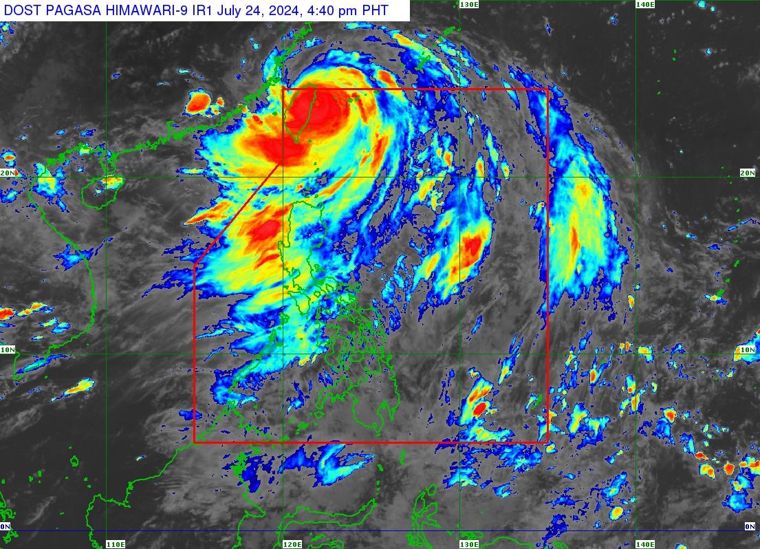
Carina is currently packing maximum sustained winds of 185 kilometers per hour (kph) near the center and gusts of up to 230 kph, up from 165 kph maximum winds and 205 kph wind gusts recorded six hours ago.

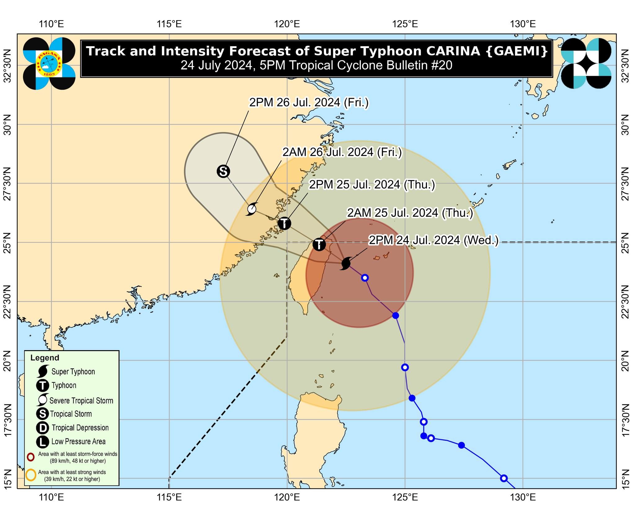
PAGASA Weather Specialist Veronica Torres said Carina has already peaked in intensity and is expected to be downgraded to a typhoon after making landfall over northern Taiwan on Wednesday evening.

However, it will still be a strong tropical cyclone and continue to pull the southwest monsoon, or “habagat,” toward the Philippines, causing intense rains and gusty winds over Metro Manila and nearby provinces in the next few hours.

As of 4 p.m., the center of the eye of the super typhoon was located 380 kilometers north of Itbayat, Batanes.

Carina is expected to continue moving northwestward at a speed of 20 kph.

Torres said the outer circulation of Carina may continue to bring severe winds over parts of northern Luzon.

As such, tropical Cyclone Wind Signal No. 2 remains hoisted over Batanes, while Signal No. 1 is still in effect over Babuyan Islands, the northern portion of mainland Cagayan (Claveria, Santa Praxedes, Sanchez-Mira, Pamplona, Abulug, Ballesteros, Aparri, Camalaniugan, Buguey, Santa Teresita, Santa Ana, Gonzaga), and the northern portion of Ilocos Norte (Burgos, Bangui, Pagudpud, Dumalneg, Adams).

Moderate to heavy rains due to Carina may also continue to affect Batanes and Babuyan Islands.

IMG_4039.jpeg
Super Typhoon Carina’s track and intensity outlook (PAGASA/Facebook)

‘Habagat’ rains to persist

In its 11 a.m. advisory, PAGASA said the habagat may continue to bring heavy to intense rains to Benguet and Abra on Thursday, July 25.

Meanwhile, moderate to heavy rains may affect Metro Manila, Cavite, Batanes, Babuyan Islands, the rest of Ilocos Region, Abra, Benguet, Zambales, Bataan, and Occidental Mindoro.

By Friday, July 26, Zambales, Bataan, and Benguet could still experience moderate to heavy rains.

“Under these conditions, flooding and rain-induced landslides are possible, especially in areas that are highly or very highly susceptible to these hazards as identified in official hazard maps and in localities that experienced considerable amounts of rainfall for the past several days,” PAGASA warned.

Carina is expected to leave the country’s area of responsibility by Thursday.

Related Tags

Super Typhoon PAGASA Habagat Super Typhoon Carina
ADVERTISEMENT
.most-popular .layout-ratio{ padding-bottom: 79.13%; } @media (min-width: 768px) and (max-width: 1024px) { .widget-title { font-size: 15px !important; } }

{{ articles_filter_1561_widget.title }}

.most-popular .layout-ratio{ padding-bottom: 79.13%; } @media (min-width: 768px) and (max-width: 1024px) { .widget-title { font-size: 15px !important; } }

{{ articles_filter_1562_widget.title }}

.most-popular .layout-ratio{ padding-bottom: 79.13%; } @media (min-width: 768px) and (max-width: 1024px) { .widget-title { font-size: 15px !important; } }

{{ articles_filter_1563_widget.title }}

{{ articles_filter_1564_widget.title }}

.mb-article-details { position: relative; } .mb-article-details .article-body-preview, .mb-article-details .article-body-summary{ font-size: 17px; line-height: 30px; font-family: "Libre Caslon Text", serif; color: #000; } .mb-article-details .article-body-preview iframe , .mb-article-details .article-body-summary iframe{ width: 100%; margin: auto; } .read-more-background { background: linear-gradient(180deg, color(display-p3 1.000 1.000 1.000 / 0) 13.75%, color(display-p3 1.000 1.000 1.000 / 0.8) 30.79%, color(display-p3 1.000 1.000 1.000) 72.5%); position: absolute; height: 200px; width: 100%; bottom: 0; display: flex; justify-content: center; align-items: center; padding: 0; } .read-more-background a{ color: #000; } .read-more-btn { padding: 17px 45px; font-family: Inter; font-weight: 700; font-size: 18px; line-height: 16px; text-align: center; vertical-align: middle; border: 1px solid black; background-color: white; } .hidden { display: none; }
function initializeAllSwipers() { // Get all hidden inputs with cms_article_id document.querySelectorAll('[id^="cms_article_id_"]').forEach(function (input) { const cmsArticleId = input.value; const articleSelector = '#article-' + cmsArticleId + ' .body_images'; const swiperElement = document.querySelector(articleSelector); if (swiperElement && !swiperElement.classList.contains('swiper-initialized')) { new Swiper(articleSelector, { loop: true, pagination: false, navigation: { nextEl: '#article-' + cmsArticleId + ' .swiper-button-next', prevEl: '#article-' + cmsArticleId + ' .swiper-button-prev', }, }); } }); } setTimeout(initializeAllSwipers, 3000); const intersectionObserver = new IntersectionObserver( (entries) => { entries.forEach((entry) => { if (entry.isIntersecting) { const newUrl = entry.target.getAttribute("data-url"); if (newUrl) { history.pushState(null, null, newUrl); let article = entry.target; // Extract metadata const author = article.querySelector('.author-section').textContent.replace('By', '').trim(); const section = article.querySelector('.section-info ').textContent.replace(' ', ' '); const title = article.querySelector('.article-title h1').textContent; // Parse URL for Chartbeat path format const parsedUrl = new URL(newUrl, window.location.origin); const cleanUrl = parsedUrl.host + parsedUrl.pathname; // Update Chartbeat configuration if (typeof window._sf_async_config !== 'undefined') { window._sf_async_config.path = cleanUrl; window._sf_async_config.sections = section; window._sf_async_config.authors = author; } // Track virtual page view with Chartbeat if (typeof pSUPERFLY !== 'undefined' && typeof pSUPERFLY.virtualPage === 'function') { try { pSUPERFLY.virtualPage({ path: cleanUrl, title: title, sections: section, authors: author }); } catch (error) { console.error('ping error', error); } } // Optional: Update document title if (title && title !== document.title) { document.title = title; } } } }); }, { threshold: 0.1 } ); function showArticleBody(button) { const article = button.closest("article"); const summary = article.querySelector(".article-body-summary"); const body = article.querySelector(".article-body-preview"); const readMoreSection = article.querySelector(".read-more-background"); // Hide summary and read-more section summary.style.display = "none"; readMoreSection.style.display = "none"; // Show the full article body body.classList.remove("hidden"); } document.addEventListener("DOMContentLoaded", () => { let loadCount = 0; // Track how many times articles are loaded const offset = [1, 2, 3, 4, 5, 6, 7, 8, 9, 10]; // Offset values const currentUrl = window.location.pathname.substring(1); let isLoading = false; // Prevent multiple calls if (!currentUrl) { console.log("Current URL is invalid."); return; } const sentinel = document.getElementById("load-more-sentinel"); if (!sentinel) { console.log("Sentinel element not found."); return; } function isSentinelVisible() { const rect = sentinel.getBoundingClientRect(); return ( rect.top < window.innerHeight && rect.bottom >= 0 ); } function onScroll() { if (isLoading) return; if (isSentinelVisible()) { if (loadCount >= offset.length) { console.log("Maximum load attempts reached."); window.removeEventListener("scroll", onScroll); return; } isLoading = true; const currentOffset = offset[loadCount]; window.loadMoreItems().then(() => { let article = document.querySelector('#widget_1690 > div:nth-last-of-type(2) article'); intersectionObserver.observe(article) loadCount++; }).catch(error => { console.error("Error loading more items:", error); }).finally(() => { isLoading = false; }); } } window.addEventListener("scroll", onScroll); });

Sign up by email to receive news.