


Typhoon Carina slightly intensifies; Signal No. 2 raised


At A Glance
- Based on PAGASA's 11 a.m. bulletin, Signal No. 2 was raised over Itbayat, Basco, Mahatao, Uyugan, and Ivana in Batanes.
- Signal No. 1 was in effect in the rest of Batanes, Cagayan including Babuyan Islands, the eastern portion of Isabela, the northern portion of Apayao, the northern portion of Ilocos Norte, the northern portion of Aurora, Polillo Islands, Calaguas Islands, and the northern portion of Catanduanes.
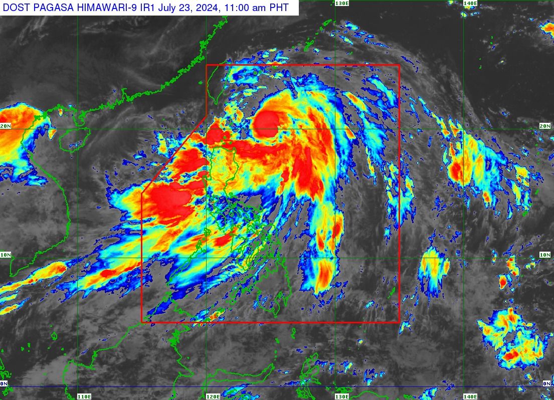
- PAGASA said that although Carina is expected to remain offshore, it may still influence the southwest monsoon, or "habagat," pulling moderate to heavy rains inland across a large portion of Luzon and parts of Western Visayas until Thursday, July 25.
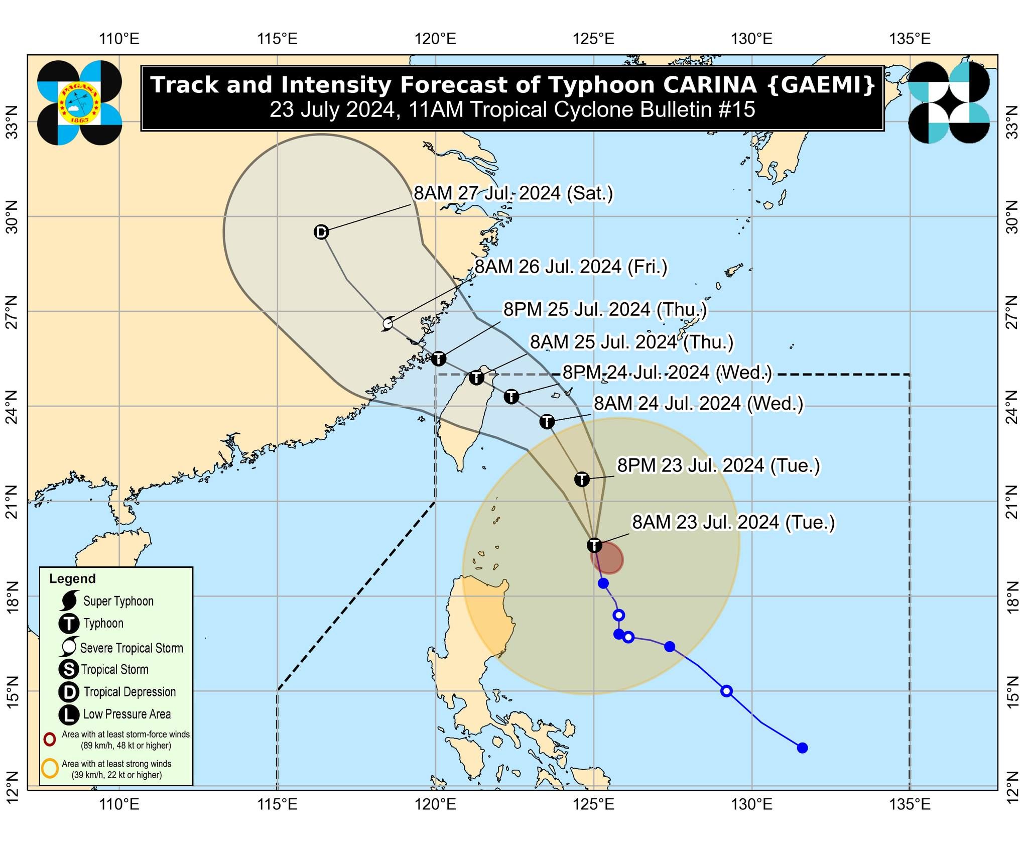
Typhoon “Carina” (international name “Gaemi”) slightly intensified while lingering over the Philippine Sea, prompting the Philippine Atmospheric, Geophysical and Astronomical Services Administration (PAGASA) to issue Wind Signal No. 2 in a portion of Batanes on Tuesday, July 23.
Based on PAGASA’s 11 a.m. bulletin, Signal No. 2 was raised over Itbayat, Basco, Mahatao, Uyugan, and Ivana in Batanes.
Meanwhile, Signal No. 1 was in effect in the rest of Batanes (Sabtang), Cagayan including Babuyan Islands, the eastern portion of Isabela (Divilacan, Palanan, Maconacon, Dinapigue, Tumauini, Ilagan City, San Mariano, Cabagan, San Pablo, Santa Maria), the northern portion of Apayao (Calanasan, Luna, Pudtol, Flora, Santa Marcela), the northern portion of Ilocos Norte (Pagudpud, Bangui, Adams, Dumalneg, Burgos, Vintar), the northern portion of Aurora (Dilasag, Casiguran), Polillo Islands, Calaguas Islands, and the northern portion of Catanduanes (Pandan, Bagamanoc, Panganiban, Viga, Gigmoto, Caramoran).
“Minor to moderate impacts from strong winds are possible within any of the localities where Wind Signal No. 2 is hoisted, [while] minimal to minor impacts from strong winds are possible within any of the areas under Wind Signal No. 1,” PAGASA warned.
Until Wednesday noon, July 24, heavy to intense rains (100 to 200 millimeters) due to the typhoon may continue in Batanes, Babuyan Islands, the northern and eastern portions of mainland Cagayan, and Ilocos Sur.
Meanwhile, moderate to heavy rains (50 to 100 millimeters) may persist in Ilocos Norte, La Union, Abra, Benguet, Apayao, the eastern portion of Isabela, and the rest of Cagayan.
From Wednesday noon to Thursday noon, July 25, heavy to intense rains may persist in Batanes, and moderate to heavy rains are expected in Babuyan Islands.
By Thursday, July 25, less intense rains are expected, with moderate to heavy rains likely in Batanes.
Typhoon-enhanced ‘habagat’
As of 10 a.m., typhoon Carina was located 320 kilometers east of Basco, Batanes, or 405 kilometers east-northeast of Aparri, Cagayan, packing maximum sustained winds of 140 kilometers per hour (kph) near the center and gusts of up to 170 kph.
It was moving westward at 15 kph.
PAGASA said that although Carina is expected to remain offshore, it may still influence the southwest monsoon, or “habagat,” pulling moderate to heavy rains inland across a large portion of Luzon and parts of Western Visayas until Thursday.
In the next few hours, the habagat is expected to bring heavy to intense rains to Metro Manila, Ilocos Region, Abra, Benguet, Zambales, Bataan, Pampanga, Bulacan, Rizal, Cavite, Batangas, and Occidental Mindoro.
Meanwhile, Apayao, Ifugao, Kalinga, Mountain Province, Nueva Vizcaya, Nueva Ecija, Tarlac, Laguna, Quezon, Oriental Mindoro, Marinduque, Romblon, Aklan, Antique, and the northern portion of Palawan, including Calamian, Cuyo, and Kalayaan Islands may experience moderate to heavy monsoon rains.
By Wednesday, heavy to intense rains may persist in Ilocos Region, Abra, Benguet, Zambales, Bataan, and Occidental Mindoro, while moderate to heavy rains may continue in Metro Manila, Aoayao, Ifugao, Kalinga, Mountain Province, Tarlac, Nueva Ecija, Pampanga, Bulacan, Rizal, Cavite, Batangas, Oriental Mindoro, and Calamian Islands.
By Thursday, moderate to heavy monsoon rains may affect Batanes, Babuyan Islands, Ilocos Region, Apayao, Abra, Benguet, Zambales, Bataan, and Occidental Mindoro.
“Under these conditions, flooding and rain-induced landslides are possible, especially in areas that are highly or very highly susceptible to these hazards as identified in official hazard maps and in localities that experienced considerable amounts of rainfall for the past several days,” PAGASA warned.
Typhoon Carina is expected to make landfall over the northern portion of Taiwan between Wednesday evening and Thursday morning, and then exit the Philippine area of responsibility hours later.