


Typhoon Carina further strengthens offshore of the Philippines


At A Glance
- Tropical Cyclone Wind Signal No. 2 is in effect over Batanes, while Signal No. 1 remains hoisted over Cagayan including Babuyan Islands, the eastern portion of Isabela, the northern portion of Apayao, and the northern portion of Ilocos Norte.
- PAGASA said Carina may continue to enhance the southwest monsoon, or "habagat," pulling moderate to heavy rains inland across a large portion of Luzon until Thursday, July 25.
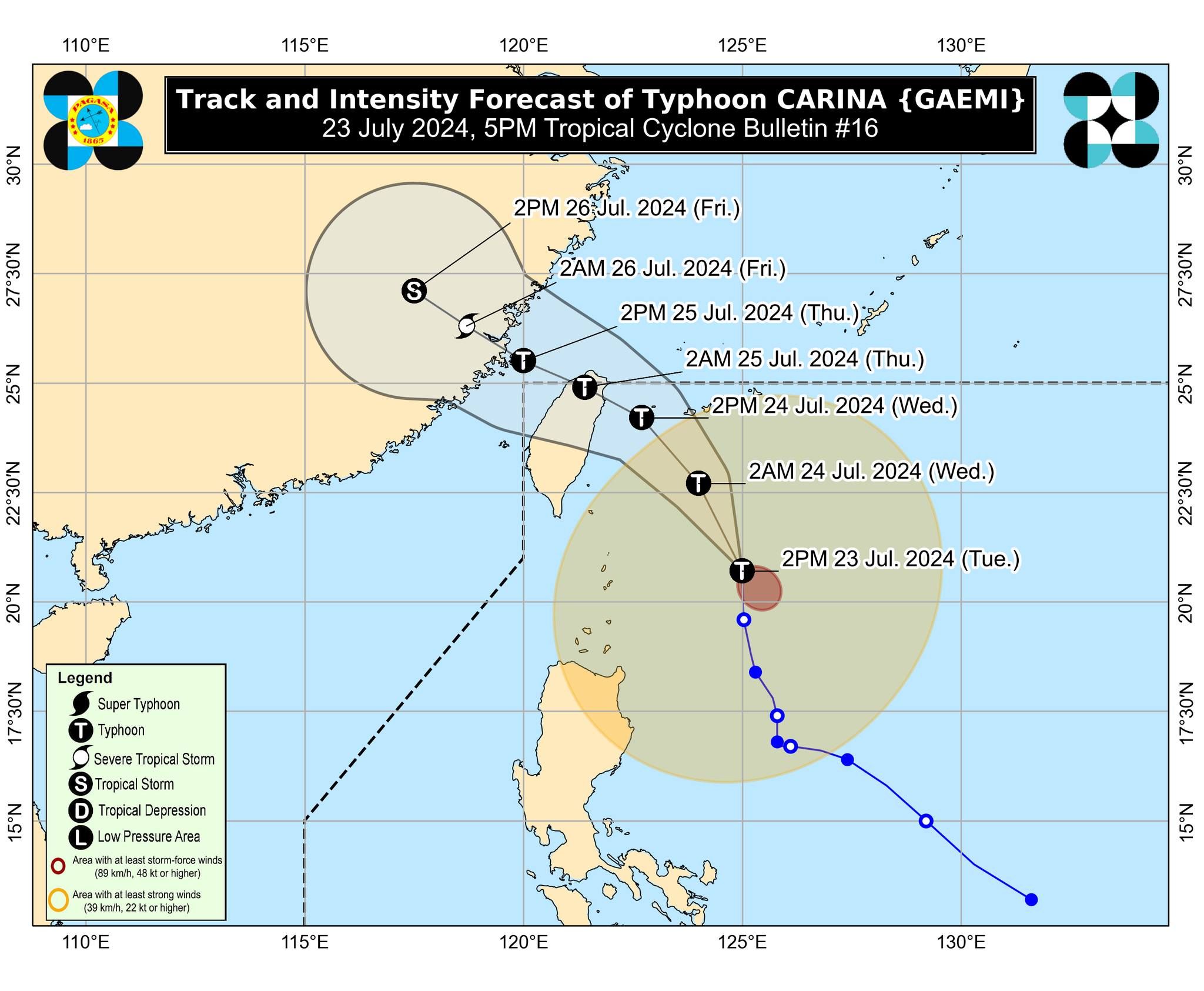
Typhoon “Carina” (international name “Gaemi”) continued to intensify while remaining offshore on Tuesday afternoon, July 23, the Philippine Atmospheric, Geophysical and Astronomical Services Administration (PAGASA) said in its 5 p.m. bulletin.
Carina now has maximum sustained winds of 150 kilometers per hour (kph) near the center and gusts of up to 185 kph, an increase from the 140 kph maximum sustained winds and 170 kph gusts recorded in the 11 a.m. bulletin.
As of 4 p.m., the center of the typhoon was located 325 kilometers east-northeast of Basco, Batanes, and was moving northward at 20 kph.
Severe winds, heavy rains
Although the typhoon is not expected to make landfall over any part of the country, PAGASA said the outer circulation of Carina may continue to bring strong winds to portions of Cagayan Valley, Cordillera Administrative Region, and Ilocos Region.
Tropical Cyclone Wind Signal No. 2 is in effect over Batanes, while Signal No. 1 remains hoisted over Cagayan including Babuyan Islands, the eastern portion of Isabela, the northern portion of Apayao, and the northern portion of Ilocos Norte.
Until Wednesday afternoon, July 24, heavy to intense rains (100 to 200 millimeters) due to the typhoon may continue in Batanes, Babuyan Islands, the northern and eastern portions of mainland Cagayan, and Ilocos Sur.
Meanwhile, moderate to heavy rains (50 to 100 millimeters) may persist in Ilocos Norte, La Union, Abra, Benguet, Apayao, the eastern portion of Isabela, and the rest of Cagayan.
From Wednesday afternoon to Thursday afternoon, July 25, heavy to intense rains may persist in Batanes, and moderate to heavy rains are expected in Babuyan Islands.
‘Habagat’ rains to persist
In its 11 a.m. weather advisory, PAGASA said Carina may continue to enhance the southwest monsoon, or “habagat,” pulling moderate to heavy rains inland across a large portion of Luzon until Thursday.
In the next few hours, the habagat is expected to bring heavy to intense rains to Metro Manila, Ilocos Region, Abra, Benguet, Zambales, Bataan, Pampanga, Bulacan, Rizal, Cavite, Batangas, and Occidental Mindoro.
Meanwhile, Apayao, Ifugao, Kalinga, Mountain Province, Nueva Vizcaya, Nueva Ecija, Tarlac, Laguna, Quezon, Oriental Mindoro, Marinduque, Romblon, Aklan, Antique, and the northern portion of Palawan, including Calamian, Cuyo, and Kalayaan Islands may experience moderate to heavy monsoon rains.
By Wednesday, heavy to intense rains may persist in Ilocos Region, Abra, Benguet, Zambales, Bataan, and Occidental Mindoro, while moderate to heavy rains may continue in Metro Manila, Aoayao, Ifugao, Kalinga, Mountain Province, Tarlac, Nueva Ecija, Pampanga, Bulacan, Rizal, Cavite, Batangas, Oriental Mindoro, and Calamian Islands.
By Thursday, moderate to heavy monsoon rains may affect Batanes, Babuyan Islands, Ilocos Region, Apayao, Abra, Benguet, Zambales, Bataan, and Occidental Mindoro.
“Under these conditions, flooding and rain-induced landslides are possible, especially in areas that are highly or very highly susceptible to these hazards as identified in official hazard maps and in localities that experienced considerable amounts of rainfall for the past several days,” PAGASA warned.
Typhoon Carina is expected to make landfall over the northern portion of Taiwan between Wednesday evening and Thursday morning, and then exit the Philippine area of responsibility hours later.