


 Philippines
National
'Carina' may become a typhoon; 'habagat' rains to persist in next 2 days
Philippines
National
'Carina' may become a typhoon; 'habagat' rains to persist in next 2 days
'Carina' may become a typhoon; 'habagat' rains to persist in next 2 days


At A Glance
- "Carina" may become a typhoon within 12 hours.
- Signal No. 1 was hoisted over the eastern portion of mainland Cagayan (Santa Ana, Gattaran, Baggao, Peñablanca, Lal-Lo, Gonzaga), including the easternportion of Babuyan Islands (Camiguin Is., Babuyan Is.), and the northeastern portion of Isabela (Divilacan, Palanan, Maconacon).
- The weather disturbance may continue to enhance the southwest monsoon, locally known as "habagat" until Wednesday, July 24.
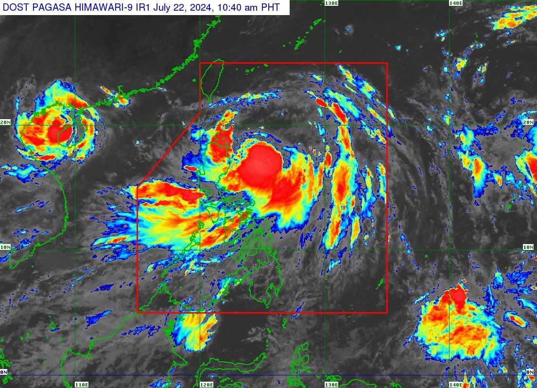
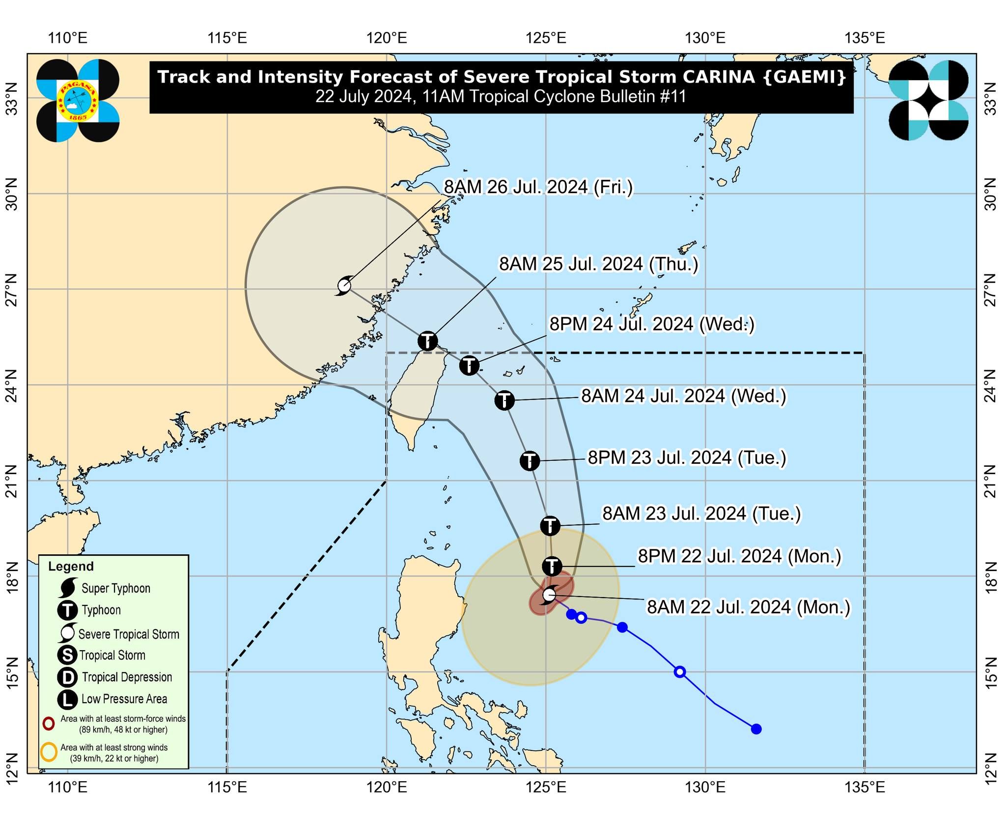
Severe tropical storm “Carina” (international name “Gaemi”) continued to intensify steadily offshore and may become a typhoon within the next 12 hours, the Philippine Atmospheric, Geophysical and Astronomical Services Administration (PAGASA) said in its 11 a.m. bulletin on Monday, July 22.
PAGASA said Carina was packing maximum sustained winds of 110 kilometers per hour (kph) near the center, with gusts of up to 135 kph, up from maximum winds of 100 kph and gusts of 125 kph at 5 a.m.
A tropical cyclone with a maximum wind speed of 118 to 184 kph is classified as a typhoon.
After being almost stationary over the Philippine Sea for the past 12 hours, Carina is currently moving northwestward at 15 kph.
Severe winds, heavy rains
Although Carina is not expected to make landfall, PAGASA has raised Tropical Cyclone Wind Signal No. 1 over the eastern portion of mainland Cagayan (Santa Ana, Gattaran, Baggao, Peñablanca, Lal-Lo, Gonzaga), including the easternportion of Babuyan Islands (Camiguin Is., Babuyan Is.), and the northeastern portion of Isabela (Divilacan, Palanan, Maconacon) due to anticipated strong winds from the storm.
The outer circulation of Carina may also bring heavy to intense rains (100 to 200 millimeters) over the extreme northeastern portion of mainland Cagayan, and moderate to heavy rains (50 to 100 millimeters) over Babuyan Islands and the eastern portions of mainland Cagayan and Isabela until Tuesday noon, July 23.
From Tuesday noon to Wednesday noon, July 24, heavy to intense rains may persist in Batanes, and moderate to heavy rains in Babuyan Islands and the northeastern portion of mainland Cagayan.
Batanes may continue to experience moderate to heavy rains from Wednesday noon to Thursday noon, July 25.
Enhanced ‘habagat’
PAGASA said Carina may also continue to enhance the southwest monsoon, locally known as “habagat,” causing heavy to intense rains over Zambales, Bataan, and Occidental Mindoro on Monday.
Moderate rains, with occasional heavy rainfall, may also occur in Metro Manila, Ilocos Region, Apayao, Abra, Benguet, Bulacan, Tarlac, Nueva Ecija, Pampanga, Aurora, Cavite, Laguna, Batangas, Rizal, Quezon, Oriental Mindoro, Marinduque, Romblon, Aklan, Antique, and northern Palawan, including Cuyo and Calamian Islands.
This scenario may prevail over most of Luzon until Wednesday.
“Under these conditions, flooding and rain-induced landslides are possible, especially in areas that are highly or very highly susceptible to these hazards as identified in official hazard maps and in localities that experienced considerable amounts of rainfall for the past several days,” PAGASA warned.
Over the Philippine Sea, Carina is projected to move generally northward until Tuesday, gradually accelerating before turning northwestward for the remainder of the forecast period.
Based on the track forecast, it is expected to exit the country’s area of responsibility on Wednesday evening or Thursday morning.