


 Philippines
National
10 Luzon areas under Signal No. 1 as typhoon Carina maintains strength
Philippines
National
10 Luzon areas under Signal No. 1 as typhoon Carina maintains strength
10 Luzon areas under Signal No. 1 as typhoon Carina maintains strength


At A Glance
- PAGASA said that although Carina is expected to remain offshore, it may still influence the southwest monsoon, or "habagat," pulling moderate to heavy rains inland across a large portion of Luzon and parts of Western Visayas until Thursday.
The Philippine Atmospheric, Geophysical and Astronomical Services Administration (PAGASA) raised Wind Signal No. 1 over 10 areas in Luzon on Tuesday, July 23, due to typhoon “Carina” (international name “Gaemi”).
As of 5 a.m., Signal No. 1 was in effect in Batanes, Babuyan Islands, the northern and eastern portions of mainland Cagayan (Santa Ana, Gattaran, Baggao, Peñablanca, Lal-Lo, Gonzaga, Buguey, Santa Teresita, Aparri, Camalaniugan, Ballesteros, Allacapan, Abulug, Pamplona, Claveria, Sanchez-Mira, Santa Praxedes, Lasam, Alcala), the eastern portion of Isabela (Divilacan, Palanan, Maconacon, Dinapigue, Tumauini, Ilagan City, San Mariano, Cabagan, San Pablo, Santa Maria), the northern portion of Apayao (Calanasan, Luna, Pudtol, Flora, Santa Marcela), the northern portion of Ilocos Norte (Pagudpud, Bangui, Adams, Dumalneg, Burgos, Vintar), the northern portion of Aurora (Dilasag, Casiguran), Polillo Islands, Calaguas Islands, and the northern portion of Catanduanes (Pandan, Bagamanoc, Panganiban, Viga, Gigmoto, Caramoran).
“Minimal to minor impacts due to strong winds may be experienced within any of the localities where Wind Signal No. 1 is hoisted,” PAGASA said in its bulletin.
In the next few hours, heavy to intense rains (100 to 200 millimeters) may continue in Batanes and Babuyan Islands, while moderate to heavy rains (50 to 100 millimeters) may persist in Ilocos Norte, Ilocos Sur, La Union, Abra, Benguet, Apayao, and Cagayan.
By Wednesday, July 24, heavy to intense rains may prevail in Batanes, and moderate to heavy rains are expected in Babuyan Islands.
By Thursday, July 25, less intense rains are expected, with moderate to heavy rains likely in Batanes.
‘Habagat’
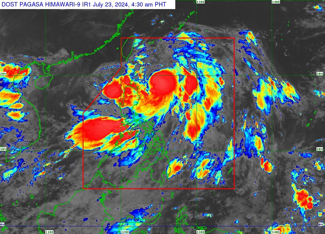
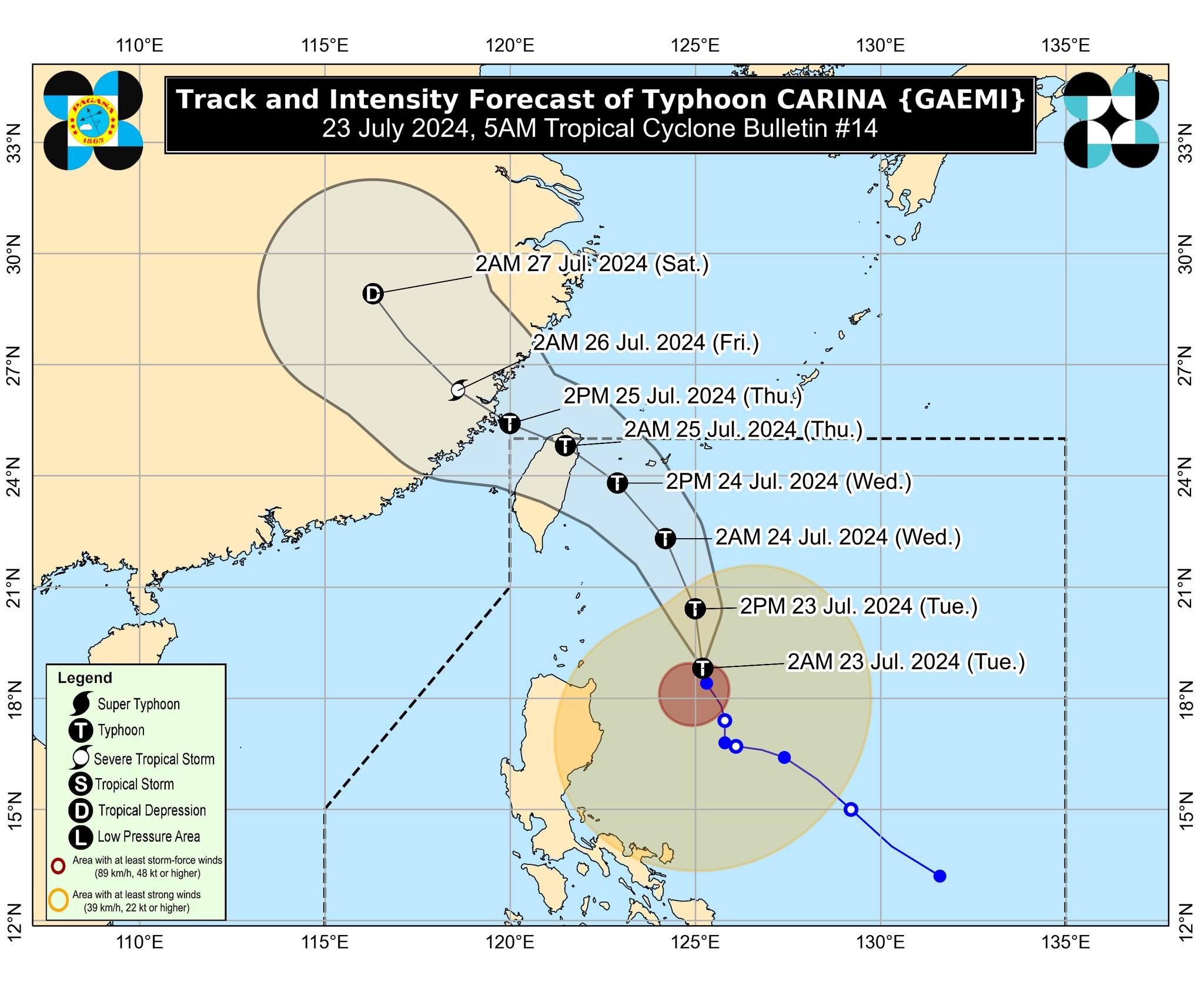
Typhoon Carina was located 380 kilometers east of Aparri, Cagayan at 4 a.m., packing maximum sustained winds of 130 kilometers per hour (kph) near the center and gusts of up to 160 kph.
It was moving west-northwestward at 10 kph.
PAGASA said that although Carina is expected to remain offshore, it may still influence the southwest monsoon, or “habagat,” pulling moderate to heavy rains inland across a large portion of Luzon and parts of Western Visayas until Thursday.
“Under these conditions, flooding and rain-induced landslides are possible, especially in areas that are highly or very highly susceptible to these hazards as identified in official hazard maps and in localities that experienced considerable amounts of rainfall for the past several days,” PAGASA warned.
The habagat, enhanced by Carina, will also bring strong to gale-force gusts over some parts of the country, especially in coastal and upland areas exposed to the winds.
In the next 24 hours, Carina and the habagat will bring moderate to rough seas over the northern and eastern seaboards of Northern Luzon outside Gale Warning areas (1.5 to 4.0 meters), the eastern seaboards of Central and Southern Luzon (1.5 to 3.0 meters), and the western seaboards of Central and Southern Luzon (1.5 to 3.5 meters).
“Mariners of small seacrafts, including all types of motorbancas, are advised not to venture out to sea under these conditions, especially if inexperienced or operating ill-equipped vessels,” PAGASA said.
Typhoon Carina is expected to make landfall over the northern portion of Taiwan between Wednesday evening and Thursday morning, and then exit the Philippine area of responsibility hours later.